
![]()
Mallowdale Pike (Mallowdale Fell)
561m (1841ft)
The South Pennines and The Forest of Bowland, Lancashire, England
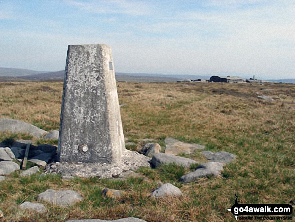
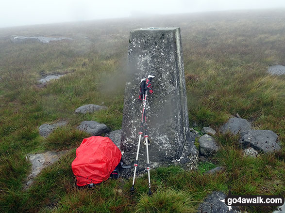
The summit of Mallowdale Pike (Mallowdale Fell) is marked by an Ordnance Survey Trig Point.
You can find Mallowdale Pike (Mallowdale Fell) & all the walks that climb it on these unique free-to-access Interactive Walk Planning Maps: (click/TAP to select)
1:25,000 scale OS Explorer Map (the ones with orange/yellow covers):
Mallowdale Pike (Mallowdale Fell) on our free-to-access 'Google Style' Peak Bagging Map:
See Mallowdale Pike (Mallowdale Fell) and the surrounding tops on our downloadable PDF Peak Bagging Map:
   |
|---|
Vital Statistics:
| Length: | 12.25ml (19.5km) |
|---|---|
| Ascent: | 1,960ft (515m) |
| Time: | 6.25hrs |
| Grade: |  (Moderate) (Moderate) |
Route Summary:
Abbeystead - Stoops Bridge - Tarnbrook Wyre - Lee - Tarnbrook - Higher Syke - Black Side of Tarnbrook Fell - Gables Clough - Tarnbrook Fell - Brown Syke - Mallowdale Pike (Mallowdale Fell) - Ward's Stone (Mallowdale Fell) - Ward's Stone Breast - Cabin Flat - Lee Fell - Grizedale Head - Rotten Hill - Margery's Hill - Higher Lee Farm - Rakehouse Barn - Grizedale Bridge - Abbeystead
|
|---|
Vital Statistics:
| Length: | 17.5ml (28km) |
|---|---|
| Ascent: | 2,186ft (666m) |
| Time: | 8½ hrs |
| Grade: |  (Hard) (Hard) |
Route Summary:
Abbeystead - Stoops Bridge - Tarnbrook Wyre - Lee - Tarnbrook - Higher Syke - Black Side of Tarnbrook Fell - Gables Clough - Tarnbrook Fell - Brown Syke - Wolfhole Crag - Mallowdale Pike (Mallowdale Fell) - Ward's Stone (Mallowdale Fell) - Ward's Stone Breast - Cabin Flat - Lee Fell - Burrow Fell - Grit Fell - Clougha Pike - Shooters Pile - Appletree Moss - Hare Appletree Fell - Jubilee Tower - Lainsley Slack - Abbeystead
 Fellow go4awalkers who have already walked, climbed, summited & bagged Mallowdale Pike (Mallowdale Fell)
Adrian Howard walked up Mallowdale Fell (Ward's Stone) on August 22nd, 2011 [from/via/route] from car park at Jubilee Tower
Christine Shepherd climbed Mallowdale Fell (Ward's Stone) on August 3rd, 2018 [from/via/route] Walked from Abbeystead using walk l101 [with] On my own [weather] Very wet & murky. - This summit loomed up out of the mist. The moorland around was a bit bleak today.
Mark Davidson bagged Mallowdale Fell (Ward's Stone) on May 12th, 2008 [with] Alone [weather] Lovely - This is a really good walk
John Cuthbert has walked, climbed & bagged Mallowdale Fell (Ward's Stone).
To add (or remove) your name and experiences on this page - Log On and edit your Personal Mountain Bagging Record
Send us your photographs and pictures on, of, or from Mallowdale Pike (Mallowdale Fell)
If you would like to add your walk photographs and pictures featuring views from, on or of Mallowdale Pike (Mallowdale Fell) to this page, please send them as email attachments (configured for any computer) along with your name to:
and we shall do our best to publish them.
(Guide Resolution = 300dpi. At least = 660pixels (wide) x 440 pixels (high).)

You can also submit photos via our Facebook Page.
NB. Please indicate where each photo was taken.


