
![]()
Dovenest Top
633m (2078ft)
The Southern Fells, The Lake District, Cumbria, England
Not familiar with this top?
You can walk/hike to the top of Dovenest Top by using either of these 2 easy‑to‑follow route maps:
Walk c139 Allen Crags, Glaramara and Seathwaite Fell from Seatoller
Peak bagging heaven
   |
|---|
Vital Statistics:
| Length: | 10.5ml (17km) |
|---|---|
| Ascent: | 3,407ft (1,038m) |
| Time: | 7.25hrs |
| Grade: |  (Hard) (Hard) |

Route Summary:
Seatoller - Big Stanger Gill - Hanging Haystack Crag - Alisongrass Crag - Rosthwaite Fell (Bessyboot) - Tarn At Leaves - Rosthwaite Cam (Rosthwaite Fell) - Dovenest Top - Combe Door Top - Combe Head - Glaramara - Looking Steads (Glaramara) - Red Beck Top - High House Tarn Top - Allen Crags - Sprinking Tarn - Seathwaite Fell (South Top) - Seathwaite Fell - Grains Gill - The Allerdale Ramble - Stockley Bridge - Seathwaite (Borrowdale) - Thornythwaite Farm - Strands Bridge - The River Derwent - Seatoller
Walk c395 Glaramara, Allen Crags and Langstrath from Stonethwaite
Terrific views - Terrific for the Peak Baggers
|
|---|
Vital Statistics:
| Length: | 10.5ml (17km) |
|---|---|
| Ascent: | 3,384ft (1,031m) |
| Time: | 7.25hrs |
| Grade: | (Hard) |

Route Summary:
Stonethwaite - Big Stanger Gill - Hanging Haystack Crag - Alisongrass Crag - Rosthwaite Fell (Bessyboot) - Tarn At Leaves - Rosthwaite Cam (Rosthwaite Fell) - Dovenest Top - Combe Door Top - Combe Head - Glaramara - Looking Steads (Glaramara) - Red Beck Top - High House Tarn Top - Allen Crags - Esk Hause - Allencrags Gill - Langstrath - Stonethwaite
See Dovenest Top and the surrounding tops on our free-to-access 'Google Style' Peak Bagging Maps:
The Southern Fells of The Lake District National Park
Less data - quicker to download
The Whole of The Lake District National Park
More data - might take a little longer to download
See Dovenest Top and the surrounding tops on our unique, downloadable, PDF Peak Bagging Maps:

NB: Whether you print off a copy or download it to your phone, these PDF Peak Baggers' Maps might prove incredibly useful when your are up there on the tops and you cannot get a phone signal.
*This version is marked with the walk routes you need to follow to Walk all 214 Wainwrights in just 59 walks.
You can find Dovenest Top & all the walks that climb it on these unique free-to-access Interactive Walk Planning Maps:
1:25,000 scale OS Explorer Map (orange/yellow covers):
1:50,000 scale OS Landranger Maps (pink/magenta covers):
 Fellow go4awalkers who have already walked, climbed, scaled, summited, hiked & bagged Dovenest Top
John Ramsbottom walked up Dovenest Top on March 16th, 2025 [from/via/route] Dow Cragg, The Old Man of Coniston,Brim Fell,Swirl How, Great Carrs & Grey Friar. Start from Seatoller, Rosthwaite Fell, Glaramara, Allen Crags & Seathwaite Fell [with] Lola [weather] Fine, Odd shower, chilly wind - First one in a while. First of 2025. Felt hard
Paul Macey climbed it on June 22nd, 2021 [from/via/route] Walk 139 [with] Luke Macey [weather] Sunny
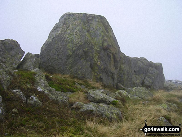
Caroline Winter bagged it on August 27th, 2019 [from/via/route] Seatoller car park, track up Rosthwaite Fell, Tarn at Leaves, Dovenest Fell. [with] Becky [weather] Gales force gusts predicted, needing to crouch & brace ourselves against wind on Rosthwaite Fell. Good visibity to Glaramara - Unable to park along road near start so back tracked to Seatoller House & parked in paid CP opposite-£6. Path disappears along Rosthwaite Fell, so climbed up to beneath Bessy Boot, where climbers could be heard. Came to Tarn at Leaves, & spotted what appeared to be Dovenest top. Found ourselves following a low route to the left, so climbed up to find the dome shaped top, as on photo in goforawalk, but nothing resembled. Got onto highest point, & altitude meter confirmed 632 M, but as other crags insight we also made way to a few others. Returned same route to car & returned home. Second attempt on 20/9/2021. Used GPS to find top this time. Reckon it is easier to locate walking from Glaramara. Third attempt 29/11/22. Walked from Seathwaite to Glaramara & then GPS to Dovenest- clear visibility & so easy to locate & definitely bagged it !
John Tippins hiked Dovenest Top on October 27th, 2022 [from/via/route] From Seatoller [with] Alone [weather] Dry to start with & mild - t-shirt mild for the ascent. Started to rain mid-morning, then rained on & off all day. Very low cloud - in cloud for most of the walk. Wind quite calm. - Not an enjoyable walk, particularly the stretch from Rosthwaite to Glaramara. Confronted with many sheer rock faces that you have to find a way over. And I forgot the warning about the scree at Aaron Crags until I was part way down. It was bad. 'Not for the faint hearted' - you're not kidding.
Kevin Foster summited on June 1st, 2021 [from/via/route] Seathwaite. [with] By myself. [weather] Sunny & Hot. - There were too many tops visited on this walk to give a full description of each one. The route of the walk roughly followed the Sty Head Tarn path via Stockley Bridge, then as the path levelled off a steep ascent up the flanks of Seathwaite Fell to reach Wainwright's Top, then the true summit (Main Top) followed by a subsidiary top (South Top). The route then went past Sprinkling Tarn & climbed to Esk Hause (not the true one) before turning left & climbing to the summit of Allen Crags. Numerous tops were then visited along the undulating & interesting ridge including Glaramara & Rosthwaite Fell before descending off the ridge by dropping left at Tarn at Leaves into the ravine of Rottenstone Gill (not as bad as it sounds!). On reaching the lane to Thorneythwaite another left turn down a tarmac road & across field paths eventually led me back to the car parked at Seathwaite. Another tiring but superb day in The Lakes. I do feel as though I am saving the best until last with these Western & Southern Fells?
To add (or remove) your name and experiences on this page - Log On and edit your Personal Mountain Bagging Record
. . . [see more walk reports]
More Photographs & Pictures of views from, on, or of, Dovenest Top

*Scafell Pike (far left back) and The Borrowdale Fells featuring Allen Crags, High House Tarn Top, Red Beck Top, Looking Stead, Glaramara, Comb Head, Comb Door Top, Dovenest Top and Rosthwaite Fell (Bessyboot) from High Raise (Langdale)

Send us your photographs and pictures on, of, or from Dovenest Top
If you would like to add your walk photographs and pictures to this page, please send them as email attachments (configured for any computer) along with your name to:
and we shall do our best to publish them.
(Guide Resolution = 300dpi. At least = 660pixels (wide) x 440 pixels (high).)

You can also submit photos via our Facebook Page.
NB. Please indicate where each photo was taken and whether you wish us to credit your photos with a Username or your First Name/Last Name.


