
![]()
Pen Pumlumon Llygad-bychan
727m (2386ft)
The Central Area, The Cambrian Mountains, Ceredigion, Wales

Not familiar with this top?
You can walk/hike to the top of Pen Pumlumon Llygad-bychan by using this easy‑to‑follow route map:
Walk ce100 Y Garn (Pumlumon), Pen Pumlumon Fawr (Plynlimon), Pen Pumlumon Llygad-bychan and Pen Pumlumon Arwystli from Nant-y-moch Reservoir
Superb views, but remote and rough walking
   |
|---|
Vital Statistics:
| Length: | 10mls (16km) |
|---|---|
| Ascent: | 2,353ft (717m) |
| Time: | 6 hrs |
| Grade: |  (Moderate) (Moderate) |

Route Summary:
Nant-y-moch Reservoir - Nant-y-moch - Y Garn (Pumlumon) - Dyll Faen - Pen y Drawsallt - Pen Pumlumon Fawr (Plynlimon) - Pumlumon Fach - Pumlumon Fach (East Top) - Pen Pumlumon Llygad-bychan - Pen Pumlumon Arwystli - Craig y March - Cwm Gwerin - Lluest y Graig - Afon Hengwm - Pantau'r Brwyn - Nant y Llyn - Maesnant - Bryn y Beddau - Nant-y-moch Reservoir
See Pen Pumlumon Llygad-bychan and the surrounding tops on our free-to-access 'Google Style' Peak Bagging Maps:
The Central AreaThe Central area of Mynyddoedd Cambria (The Cambrian Mountains)
Less data - quicker to download
Mynyddoedd Cambria (The Cambrian Mountains)
Less data - quicker to download
A go4awalk.com downloadable Peak Bagging Map in PDF format featuring Pen Pumlumon Llygad-bychan should be available soon.
Free-to-access Interactive Walk Planning Maps:
1:25,000 scale OS Explorer Map (orange/yellow covers):
An Interactive Walk Planning Map for OS Explorer 213 Aberystwyth & Cwm Rheidol is not currently available
1:50,000 scale OS Landranger Map (pink/magenta covers):
An Interactive Walk Planning Map for OS Landranger 135 Aberystwyth & Machynlleth is not currently available
 Fellow go4awalkers who have already walked, climbed, scaled, summited, hiked & bagged Pen Pumlumon Llygad-bychan
Stephanie Doyle walked up Pen Pumlumon Llygad-bychan on January 17th, 2026 [with] Friend [weather] Wet, & windy, bursts of sun - Great views
Mark Davidson climbed it on June 3rd, 2010 [from/via/route] Walk ce100 Y Garn (Pumlumon), Pen Pumlumon Fawr (Plynlimon), Pen Pumlumon Llygad-bychan & Pen Pumlumon Arwystli from Nant-y-moch Reservoir [with] Alone [weather] Warm & sunny
Donovan Suddell bagged it on July 14th, 2021 [from/via/route] Nant-Y-Moch Reservoir using route no ce100 [with] solo [weather] sunny intervals - ce100 route is fine for ascent, but after reaching Pen Pumlumon Arwystli, I recommend returning to Pen Pumlumon Fawr & descending via Llyn Llygad & parallel to Nant y Llyn. The descent on ce100 is far too boggy.
Bleddyn Rhys hiked Pen Pumlumon Llygad-bychan on May 4th, 2019 [from/via/route] O Eisteddfa Gurig, ar hyd i Arwystli ag yn ol, wedyn lawr ac ar draws top y goedwig i'r Garn cyn dod lawr ochor arall i'r lon o'r gronfa ddwr a cerdded allan i Ponterwyd. 4 awr [with] Ar ben fy hyn... [weather] Eithaf braf ond 'hazy' - gwynt ar y topiau. - Gwersylla yn Pontarfynach hefo Mona a Dans a Kev a Ceri. Penwythnos braf iawn. Gweld y Gog.
Christina Lander summited on April 18th, 2015 [from/via/route] Nant-y-Moch reservoir - Y Garn (Pumlumon) - Pen Pumlumon Fawr - Pen Pumlumon Llygad-bychan - Pen Pumlumon Arwystli - Nant-y-Moch reservoir [with] Dick [weather] Clear blue skies but very windy
Wyn Griffiths conquered it on June 14th, 2014 [from/via/route] Nant y Moch [with] Me [weather] Sunny AM Overcast PM - A lovely range of mountains Training for Welsh 3000 15.7 Klms in 5:04 Ave 3.1 km/h
Paul Booth, Trevor Williams and Richard Penney have all walked, climbed & bagged Pen Pumlumon Llygad-bychan.
To add (or remove) your name and experiences on this page - Log On and edit your Personal Mountain Bagging Record
More Photographs & Pictures of views from, on, or of, Pen Pumlumon Llygad-bychan
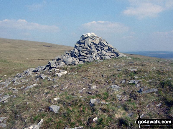
Large cairn on the shallow bwlch between Pen Pumlumon Fawr (Plynlimon) and Pen Pumlumon Llygad-bychan

360� Panorama from the summit of Pen Pumlumon Fawr (Plynlimon) featuring: Y Garn (Pumlumon), Nant-y-moch Reservoir, Drosgol (Pumlumon), Pumlumon Fach, Pen Pumlumon Arwystli and Pen Pumlumon Llygad-bychan
Send us your photographs and pictures on, of, or from Pen Pumlumon Llygad-bychan
If you would like to add your walk photographs and pictures to this page, please send them as email attachments (configured for any computer) along with your name to:
and we shall do our best to publish them.
(Guide Resolution = 300dpi. At least = 660pixels (wide) x 440 pixels (high).)

You can also submit photos via our Facebook Page.
NB. Please indicate where each photo was taken and whether you wish us to credit your photos with a Username or your First Name/Last Name.


