
![]()
Moel Gornach (Garreg Lwyd)
616m (2021ft)
The Brecon Beacons Area, The Brecon Beacons, Carmarthenshire, Wales
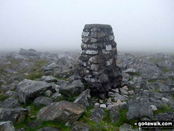
The summit of Moel Gornach (Garreg Lwyd) is marked by an Ordnance Survey Trig Point.
You can find Moel Gornach (Garreg Lwyd) & all the walks that climb it on these unique free-to-access Interactive Walk Planning Maps: (click/TAP to select)
1:25,000 scale OS Explorer Map (the ones with orange/yellow covers):
1:50,000 scale OS Landranger Map (the ones with pink/magenta covers):
See Moel Gornach (Garreg Lwyd) and the surrounding tops on our free-to-access 'Google Style' Peak Bagging Maps:
See Moel Gornach (Garreg Lwyd) and the surrounding tops on our downloadable PDF Peak Bagging Map:
   |
|---|
Vital Statistics:
| Length: | 1.5ml (2.5km) |
|---|---|
| Ascent: | 440ft (134m) |
| Time: | 1 hrs |
| Grade: |  (Easy) (Easy) |
 Fellow go4awalkers who have already walked, climbed, summited & bagged Moel Gornach (Garreg Lwyd)
Alan Smith walked up Moel Gornach (Garreg Lwyd) on April 3rd, 2023 [from/via/route] With Lisa from the quarry [weather] sunshine
Toby Norman climbed Moel Gornach (Garreg Lwyd) on February 28th, 2022 [from/via/route] Mountain Road Car Park,Llangadog [with] Burrows
Sion Britton bagged Moel Gornach (Garreg Lwyd) on August 24th, 2020 [from/via/route] Maes Parcio Mountain Road [weather] Braf/ Cymylog
Mark Davidson hiked Moel Gornach (Garreg Lwyd) on July 7th, 2009 [with] MK [weather] Mist & fog
Victoria Bates summited Moel Gornach (Garreg Lwyd) on December 5th, 2015 [from/via/route] Cm 101 [with] Mark [weather] windy & misty
Christina Lander conquered Moel Gornach (Garreg Lwyd) on May 25th, 2015 [from/via/route] Foel Fawr - disused quarry - Moel Gornach - Foel Fawr [with] Dick [weather] Gorgeous, clear sunny evening - Our last mountain in the Brecon Beacons, we have now climbed them all, & many of them several times!
Jospeh Seddon, Matthew Thomas, Daniel Graham, Michael Rygol, John Cuthbert, Paul Booth, Trevor Williams and Richard Penney have all walked, climbed & bagged Moel Gornach (Garreg Lwyd).
To add (or remove) your name and experiences on this page - Log On and edit your Personal Mountain Bagging Record
Send us your photographs and pictures on, of, or from Moel Gornach (Garreg Lwyd)
If you would like to add your walk photographs and pictures featuring views from, on or of Moel Gornach (Garreg Lwyd) to this page, please send them as email attachments (configured for any computer) along with your name to:
and we shall do our best to publish them.
(Guide Resolution = 300dpi. At least = 660pixels (wide) x 440 pixels (high).)

You can also submit photos via our Facebook Page.
NB. Please indicate where each photo was taken.


