
![]()
Drygarn Fawr
645m (2116ft)
The South Western Area, The Cambrian Mountains, Powys, Wales
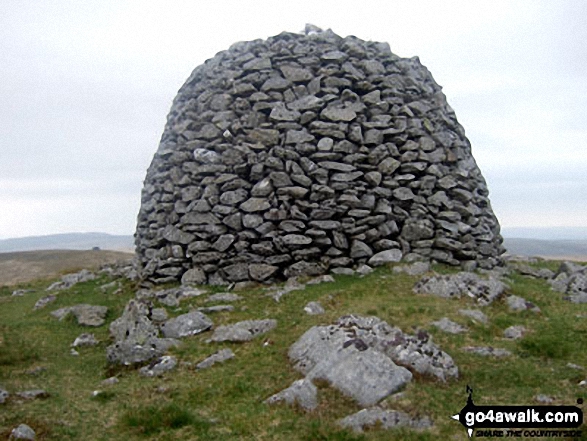
The summit of Drygarn Fawr is marked by a huge beehive shaped cairn 100m NE of an Ordnance Survey Trig Point.
Not familiar with this top?
You can walk/hike to the top of Drygarn Fawr by using this easy‑to‑follow route map:
Walk po125 Gorllwyn (Pen y Gorllwyn) and Drygarn Fawr from Dolymynach Reservoir
Huge views - but tricky in mist
   |
|---|
Vital Statistics:
| Length: | 11mls (17.5km) |
|---|---|
| Ascent: | 1,900ft (579m) |
| Time: | 6 hrs |
| Grade: |  (Moderate) (Moderate) |
Route Summary:
Dolymynach Reservoir - Afon Claerwen - Llanerch Cawr - Llywdnant - Marchnant - Gorllwyn (Pen y Gorllwyn) - Bwlch Ddau Faen - Carnau - Bryn Rhudd - Drygarn Fawr (North East Top) - Drygarn Fawr - Carreg Yr Ast - Nant Paradwys - Rhiwnant - Dolymynach Reservoir
See Drygarn Fawr and the surrounding tops on our free-to-access 'Google Style' Peak Bagging Maps:
The South Western AreaThe South Western Area of Mynyddoedd Cambria (The Cambrian Mountains)
Less data - quicker to download
Mynyddoedd Cambria (The Cambrian Mountains)
Less data - quicker to download
A go4awalk.com downloadable Peak Bagging Map in PDF format featuring Drygarn Fawr should be available soon.
Free-to-access Interactive Walk Planning Maps:
1:25,000 scale OS Explorer Maps (orange/yellow covers):
An Interactive Walk Planning Map for OS Explorer 200 Llandrindod Wells & Elan Valley is not currently available
An Interactive Walk Planning Map for OS Explorer 187 Llandovery / Llanymddyfri, Llanwrtyd Wells & Llyn Brianne is not currently available
1:50,000 scale OS Landranger Map (pink/magenta covers):
An Interactive Walk Planning Map for OS Landranger 147 Elan Valley & Builth Wells is not currently available
 Fellow go4awalkers who have already walked, climbed, scaled, summited, hiked & bagged Drygarn Fawr
Donovan Suddell walked up Drygarn Fawr on April 14th, 2022 [from/via/route] Elan Valley [with] Solo [weather] Rainy Morning, brightened up in the afternoon - Got lost between Gorllwyn & Drygan Fawr. :-(
Bleddyn Rhys climbed it on June 2nd, 2018 [from/via/route] Fynnu o Cwm Elan, Drygan Fawr, ar draws i Gorllwyn a lawr yn ol drwy'r chwaral. [with] ar ben fy hyn! [weather] Braf iawn - mini heatwave! - Speed-hiking! 16Km 3 awr a hanner car to car. Pell ac anghysbell iawn - dim byd am filltiroedd! Wlyb iawn a chorsiog - braf fod hi wedi bod yn sych ers wythnosau neu fyddai'n anodd iawn. Navigation da yn critical.
Christina Lander bagged it on May 30th, 2015 [from/via/route] Llanerch Cawr - Gorllwyn - Carnau - Drygarn Fawr - Carreg yr Ast - Llanerch Cawr [with] Dick [weather] Fine, high cloud
Jacqueline Debbie Tonks hiked Drygarn Fawr during 2012 - This is a walk we have done many times, always with good weather & views
Mark Davidson summited on May 26th, 2010 [with] alone [weather] bit cloudy but dry - Not may paths & a bit boggy in places - but the route instructions are spot on.
Richard Penney conquered it on September 17th, 2012 [from/via/route] Elan Valley [with] Solo [weather] Started fab, turned grot within 2 hours. Met office completely wrong. - Got a bit lost - bogs everywhere.
John Cuthbert, Paul Booth, Trevor Williams and Paul Donoghue have all walked, climbed & bagged Drygarn Fawr.
To add (or remove) your name and experiences on this page - Log On and edit your Personal Mountain Bagging Record
More Photographs & Pictures of views from, on, or of, Drygarn Fawr


Send us your photographs and pictures on, of, or from Drygarn Fawr
If you would like to add your walk photographs and pictures to this page, please send them as email attachments (configured for any computer) along with your name to:
and we shall do our best to publish them.
(Guide Resolution = 300dpi. At least = 660pixels (wide) x 440 pixels (high).)

You can also submit photos via our Facebook Page.
NB. Please indicate where each photo was taken and whether you wish us to credit your photos with a Username or your First Name/Last Name.


