
![]()
Carnedd y Ddelw
688m (2258ft)
The Carneddau, Snowdonia, Conwy/Gwynedd, Wales
Carnedd y Ddelw was demoted from 'Nuttall' status in May, 2017. It becomes a 'Bridget'.
Carnedd y Ddelw means 'Cairn of the Idol' in Welsh.
The summit of Carnedd y Ddelw is marked by a large cairn / shelter.

Not familiar with this top?
You can walk/hike to the top of Carnedd y Ddelw by using any of these 5 easy‑to‑follow route maps:
Walk cw208 Drum (Carneddau) from Bwlch y Ddeufaen
Quiet lonely hills with fine views
   |
|---|
Vital Statistics:
| Length: | 8.25ml (13km) |
|---|---|
| Ascent: | 1,906ft (581m) |
| Time: | 4.75hrs |
| Grade: |  (Moderate) (Moderate) |

Route Summary:
Bwlch y Ddeufaen - Carnedd y Ddelw - Drum (Carneddau) - Pen y Castell - Bron-y-Gadair - Cae Coch - Bwlch y Ddeufaen
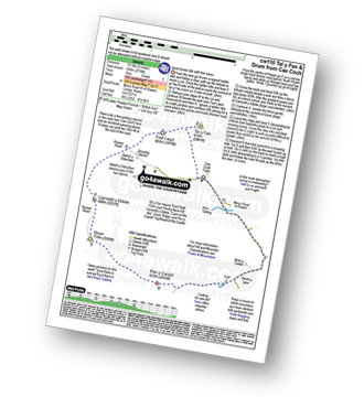
Walk cw110 Tal y Fan and Drum (Carneddau) from Cae Coch
Quiet lonely hills with fine views
|
|---|
Vital Statistics:
| Length: | 8.75ml (14km) |
|---|---|
| Ascent: | 2,736ft (834m) |
| Time: | 6 hrs |
| Grade: |  (Moderate) (Moderate) |
Route Summary:
Cae Coch - Tal y Fan - Foel Lwyd - Bwlch y Ddeufaen - Carnedd y Ddelw - Drum (Carneddau) - Pen y Castell - Bron-y-Gadair - Cae Coch
Walk gw193 Foel Fras from Bont Newydd
Fine views of the coast & Carneddau
|
|---|
Vital Statistics:
| Length: | 9.75ml (15.5km) |
|---|---|
| Ascent: | 3,165ft (965m) |
| Time: | 6.75hrs |
| Grade: |  (Hard) (Hard) |

Route Summary:
Bont Newydd - Afon Rhaeadr-fawr - Aber Falls (Rhaeadr-fawr) - Afon Goch - Llwytmor - Foel-fras (Carneddau) - Drum (Carneddau) - Carnedd y Ddelw - Yr Orsedd - Roman Road - Llyn Anafon Access Track - Bont Newydd
Walk cw283 Tal y Fan, Foel-ganol, Yr Orsedd and Drum (Carneddau) from Cae Coch
Quiet lonely hills with fine views
|
|---|
Vital Statistics:
| Length: | 12.25ml (19.5km) |
|---|---|
| Ascent: | 3,529ft (1,076m) |
| Time: | 8 hrs |
| Grade: |  (Hard) (Hard) |

Route Summary:
Cae Coch - Tal y Fan - Foel Lwyd - Bwlch y Ddeufaen - Foel Dduarth - Foel-ganol - Yr Orsedd - Pen Bryn-du - Carnedd y Ddelw - Drum (Carneddau) - Pen y Castell - Bron-y-Gadair - Cae Coch
Walk gw183 Bera Bach, Foel Grach and Drum (Carneddau) from Bont Newydd
Fine views of the coast and the Carneddau
|
|---|
Vital Statistics:
| Length: | 14.75ml (23.5km) |
|---|---|
| Ascent: | 3,890ft (1,186m) |
| Time: | 9.25hrs |
| Grade: | (Hard) |

Route Summary:
Bont Newydd - Afon Rhaeadr-fawr - Aber Falls (Rhaeadr-fawr) - Afon Gam - Gyrn Wigua - Drosgl - Bera Bach - Bera Mawr - Yr Aryg - Carnedd Gwenllian (Carnedd Uchaf) - Foel Grach - Foel-fras - Drum (Carneddau) - Carnedd y Ddelw - Yr Orsedd - Roman Road - Llyn Anafon Access Track - Bont Newydd
See Carnedd y Ddelw and the surrounding tops on our free-to-access 'Google Style' Peak Bagging Maps:
The Carneddau of Snowdonia National Park
Less data - quicker to download
The Whole of Snowdonia National Park
More data - might take a little longer to download
See Carnedd y Ddelw and the surrounding tops on our unique, downloadable, PDF Peak Bagging Map:

NB: Whether you print off a copy or download it to your phone, this PDF Peak Baggers' Map might prove incredibly useful when your are up there on the tops and you cannot get a phone signal.
You can find Carnedd y Ddelw & all the walks that climb it on these unique free-to-access Interactive Walk Planning Maps:
1:25,000 scale OS Explorer Map (orange/yellow covers):
1:50,000 scale OS Landranger Map (pink/magenta covers):
 Fellow go4awalkers who have already walked, climbed, scaled, summited, hiked & bagged Carnedd y Ddelw
Sion Britton walked up Carnedd y Ddelw on September 4th, 2021 [from/via/route] O Abergwyngregyn. [with] Solo [weather] Cymylog.
Andy Buxton climbed it during August, 1963 [with] Dad
Mark Davidson bagged it on August 6th, 2002 [with] Alone [weather] Warm with high cloud but a bit hazy - Route directions for this walk are excellent
Patrick Rogozinski, Paul Roddam, Linda Mckeogh and Paul Booth have all walked, climbed & bagged Carnedd y Ddelw.
To add (or remove) your name and experiences on this page - Log On and edit your Personal Mountain Bagging Record
Send us your photographs and pictures on, of, or from Carnedd y Ddelw
If you would like to add your walk photographs and pictures to this page, please send them as email attachments (configured for any computer) along with your name to:
and we shall do our best to publish them.
(Guide Resolution = 300dpi. At least = 660pixels (wide) x 440 pixels (high).)

You can also submit photos via our Facebook Page.
NB. Please indicate where each photo was taken and whether you wish us to credit your photos with a Username or your First Name/Last Name.


