
![]()
Craig Eigiau
735m (2412ft)
The Carneddau, Snowdonia, Conwy, Wales
Craig Eigiau means 'Fish Shoal Rock' in Welsh and is pronounced 'cry-gay-g-ee-eye'.
The summit of Craig Eigiau is marked by a rocky outcrop.
Not familiar with this top?
You can walk/hike to the top of Craig Eigiau by using any of these 3 easy‑to‑follow route maps:
Walk cw126 Craig Eigiau and Pen Llithrig y Wrach from Llyn Eigiau
Superb mountain walk with fine views
   |
|---|
Vital Statistics:
| Length: | 9.5ml (15km) |
|---|---|
| Ascent: | 2,714ft (827m) |
| Time: | 6.25hrs |
| Grade: |  (Moderate) (Moderate) |
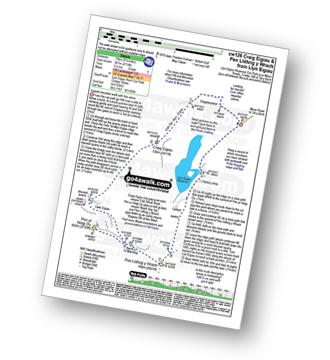
Route Summary:
Llyn Eigiau - Craig Eigiau - Cwm Eigiau - Pen Yr Helgi Du - Bwlch Tri y Marchog - Pen Llithrig y Wrach - Cedryn - Hafod-y-rhrw - Llyn Eigiau
Walk cw199 Carnedd Llewelyn, Foel Grach and Pen Llithrig y Wrach from Llyn Eigiau
Superb mountain walk with fine views
|
|---|
Vital Statistics:
| Length: | 11ml (17.5km) |
|---|---|
| Ascent: | 3,641ft (1,110m) |
| Time: | 7.75hrs |
| Grade: |  (Hard) (Hard) |

Route Summary:
Llyn Eigiau - Craig Eigiau - Gwaun Y Garnedd - Foel Grach - Carnedd Llewelyn - Craig Yr Ysfa - Bwlch Eryl Farchog - Pen yr Helgi Du - Bwlch y Tri Marchog - Pen Llithrig y Wrach - Cedryn - Hafod-y-rhrw - Llyn Eigiau
Walk cw146 Craig Eigiau, Pen Llithrig y Wrach and Creigiau Gleision from Llyn Eigiau
Superb mountain walk
|
|---|
Vital Statistics:
| Length: | 13.5ml (21.5km) |
|---|---|
| Ascent: | 4,477ft (1,364m) |
| Time: | 9½ hrs |
| Grade: |  (Hard) (Hard) |

Route Summary:
Llyn Eigiau - Craig Eigiau - Cwm Eigiau - Pen Yr Helgi Du - Bwlch Tri Marchog - Pen Llithrig y Wrach - Llyn Colwyd Reservoir - Craiglwyn - Creigiau Gleision - Creigiau Gleision (North Top) - Eilio Farm - Llyn Eigiau
See Craig Eigiau and the surrounding tops on our free-to-access 'Google Style' Peak Bagging Maps:
The Carneddau of Snowdonia National Park
Less data - quicker to download
The Whole of Snowdonia National Park
More data - might take a little longer to download
See Craig Eigiau and the surrounding tops on our unique, downloadable, PDF Peak Bagging Map:

NB: Whether you print off a copy or download it to your phone, this PDF Peak Baggers' Map might prove incredibly useful when your are up there on the tops and you cannot get a phone signal.
You can find Craig Eigiau & all the walks that climb it on these unique free-to-access Interactive Walk Planning Maps:
1:25,000 scale OS Explorer Map (orange/yellow covers):
1:50,000 scale OS Landranger Map (pink/magenta covers):
 Fellow go4awalkers who have already walked, climbed, scaled, summited, hiked & bagged Craig Eigiau
Christina Lander walked up Craig Eigiau on July 29th, 2022 [from/via/route] Llyn Eigiau - Pen Llithrig y Wrach, Pen yr Helgu Du - Carnedd Llywelyn - Foel Grach - Craig Eigiau - Llyn Eigiau [with] Dick & Libby [weather] Sunny day - Cwm Eigiau Horseshoe taking in 2 aircraft crash sites
Melfyn Parry climbed it on November 7th, 2021 [from/via/route] Cwm Eigiau. Start point at SH731663, proceed along track to the old dam at Llyn Eigiau. Follow path to disused quarry buildings at SH702636. Navigate up wetlands, to Llyn Llyffant, here there are lots of pieces of the wreckage of a Canberra aircraft. Head from here towards Melynllyn, when you reach the path coming down from Foel Grach turn towards Craig Eigiau heading for SH713654. Path leads down from here until you meet the path coming down from Melynllyn. Follow track to lead back to start. [with] PRC [weather] Good, excellent visibility - From old quarry buildings up to Llyn Llyffant is very wet/boggy underfoot
Andy Buxton bagged it during August, 1964 [from/via/route] Ogwen to Llanfairfechan [with] Dad - Pen helgi, Pen Llitric, Craig Eigiau & Pen y Castell
Mark Davidson hiked Craig Eigiau on June 26th, 2003 [with] Alone [weather] Sunny & very hot - long tiring walk in such conditions - Ran out of water towards the end
Robert Taylor-Marriott summited on November 13th, 2012 [from/via/route] Route 44: Craig Eigiau (CE) [with] Vince Wetton and Robert Taylor-Marriott [weather] Cloudy, hard rain & wind.
Vince Wetton conquered it on November 13th, 2012 [with] RTM [weather] Rain & High Winds
Louis Smith and Linda Mckeogh have both walked, climbed & bagged Craig Eigiau.
To add (or remove) your name and experiences on this page - Log On and edit your Personal Mountain Bagging Record
More Photographs & Pictures of views from, on, or of, Craig Eigiau

Send us your photographs and pictures on, of, or from Craig Eigiau
If you would like to add your walk photographs and pictures to this page, please send them as email attachments (configured for any computer) along with your name to:
and we shall do our best to publish them.
(Guide Resolution = 300dpi. At least = 660pixels (wide) x 440 pixels (high).)

You can also submit photos via our Facebook Page.
NB. Please indicate where each photo was taken and whether you wish us to credit your photos with a Username or your First Name/Last Name.

