The South Western Area of Mynyddoedd Cambria (The Cambrian Mountains) - 66 Mountains, Tops, Peaks and Hills to climb and bag
The South Western Area of The South Western Area of Mynyddoedd Cambria (The Cambrian Mountains) is the area enclosed by:
- the A44 from Aberystwyth to Llangurig to the North; the A470 from Llangurig via Rhayader to Builth Wells to the East;
- the A483 from Builth Wells to Llandovery, and then the Brecon Beacons National Park boundary to Ffairfach to the South East;
- the B4300 from Ffairfach to Caerfyrddin/Carmarthen to the South; the A484 from Caerfyrddin/Carmarthen to Cynwy Elfed, the B4333 to Newcastle Emlyn and then the A484 to Ceredigion/Cardigan to the South West;
- the Irish Sea from Ceredigion/Cardigan to Aberystwyth to the West;
There are 66 'tops' to walk up, bag and conquer, the highest point is Drygarn Fawr and the area includes:
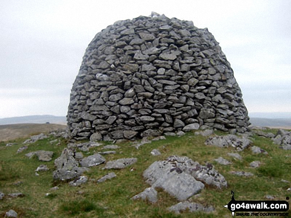 Drygarn Fawr in The South Western Area of Mynyddoedd Cambria (The Cambrian Mountains)
Photo: Colin France
| 0 | Wainwrights | |
| 3 | Mountains (aka Hewitts) | |
| 34 | Deweys | |
| 3 | Nuttalls | |
| 0 | Wainwright Outlying Fells | |
| 10 | Marilyns | |
| 22 | Hills (aka Bridgets) and | |
| 27 | Mountains, Tops, Peaks or Hills with a Trig Point on or near the top |
View these Mountains, Tops, Peaks and Hills in The South Western Cambrian Mountains:-
- On an Interactive Google Map Only (loads faster)
- On an Interactive Google Map with a list of tops below it (makes it easier to locate a particular top)
- On a Detailed List in:
Alphabetical Order | Height Order - On one page with 'yet-to-be-bagged' listed 1st & then 'already-bagged' tops listed 2nd in:
Alphabetical Order | Height Order - On one page with 'already-bagged' tops listed 1st & then 'yet-to-be-bagged' tops listed 2nd in:
Alphabetical Order | Height Order


