All the Mountains, Peaks, Tops and Hills in Wales, Wales as a detailed list
Wales is defined as the whole of the principality of Wales which includes the National Parks of Snowdonia,
Bannau Brycheiniog (The Brecon Beacons) and The Pembrokeshire Coast as well as Mynyddoedd Cambria (The Cambrian Mountains), Radnor Forest, Anglesey, The Llynn Peninsula, The Preseli Mountains and The Gower Peninsula.
If you count only the Nuttalls there are 188 tops to climb, bag & conquer and the highest point is Snowdon (Yr Wyddfa) at 1,085m (3,561ft).
To see all Mountains, Peaks, Tops and Hills displayed in different ways - see the options in the left-hand column and towards the bottom of this page.
LOG ON and RELOAD this page to show which Mountains, Peaks, Tops and Hills you have already climbed, bagged & conquered [. . . more]
Page 6 of 7 Go to page:
1 2 3 4 5 6 7 |
See this list in: Alphabetical Order‡
| Height Order
To reverse the order select the link again.
Mountain, Peak, Top or Hill:
Bagged
151. Post Gwyn
665m (2,182ft)
Mountain (92nd in Wales, 223rd in England & Wales)
Nuttall (122nd in Wales, 297th in England & Wales)
To walk, climb & bag Post Gwyn use either of these easy to follow walks:
See the location of Post Gwyn and walks up it on a google MapPost Gwyn is on interactive maps:
OS Explorer (Orange Covers): 255
OS Landranger (Pink Covers): 125
Post Gwyn is on Peak Bagging Map and Hill Tick List:
|
152. Pumlumon Fach
664m (2,179ft)
Nuttall (123rd in Wales, 299th in England & Wales)
To walk, climb & bag Pumlumon Fach use this easy to follow walk:
See the location of Pumlumon Fach and walks up it on a google MapPumlumon Fach is on interactive maps:
OS Explorer (Orange Covers): 213
OS Landranger (Pink Covers): 135
A go4awalk.com Peak Bagging Map and Hill Tick List featuring Pumlumon Fach will be available soon. |
153. Rhinog Fach
712m (2,337ft)
Mountain (63rd in Wales, 156th in England & Wales)
Nuttall (82nd in Wales, 198th in England & Wales)
Marilyn (31st in Wales, 559th in GB)
Rhinog Fach was promoted to Marilyn status in August, 2021
To walk, climb & bag Rhinog Fach use this easy to follow walk:
See the location of Rhinog Fach and walks up it on a google MapRhinog Fach is on interactive maps:
OS Explorer (Orange Covers): OL18
OS Landranger (Pink Covers): 124
Rhinog Fach is on Peak Bagging Map and Hill Tick List:
|
154. Rhinog Fawr
720m (2,363ft)
Mountain (61st in Wales, 148th in England & Wales)
Nuttall (77th in Wales, 185th in England & Wales)
Marilyn (30th in Wales, 548th in GB)
OS Trig Point
To walk, climb & bag Rhinog Fawr use this easy to follow walk:
See the location of Rhinog Fawr and walks up it on a google MapRhinog Fawr is on interactive maps:
OS Explorer (Orange Covers): OL18
OS Landranger (Pink Covers): 124
Rhinog Fawr is on Peak Bagging Map and Hill Tick List:
|
155. Rhobell Fawr
734m (2,408ft)
Mountain (57th in Wales, 137th in England & Wales)
Nuttall (71st in Wales, 169th in England & Wales)
Marilyn (27th in Wales, 518th in GB)
OS Trig Point
To walk, climb & bag Rhobell Fawr use this easy to follow walk:
See the location of Rhobell Fawr and walks up it on a google MapRhobell Fawr is on interactive maps:
OS Explorer (Orange Covers): OL23
OS Landranger (Pink Covers): 124
Rhobell Fawr is on Peak Bagging Map and Hill Tick List:
|
156. Rhos Dirion
713m (2,340ft)
Nuttall (80th in Wales, 196th in England & Wales)
OS Trig Point
To walk, climb & bag Rhos Dirion use any of these easy to follow walks:
See the location of Rhos Dirion and walks up it on a google MapRhos Dirion is on interactive maps:
OS Explorer (Orange Covers): OL13
OS Landranger (Pink Covers): 161
Rhos Dirion is on Peak Bagging Map and Hill Tick List:
|
157. Snowdon (Yr Wyddfa)
1,085m (3,561ft)
Mountain (1st in Wales, 1st in England & Wales)
Nuttall (1st in Wales, 1st in England & Wales)
Marilyn (1st in Wales, 43rd in GB)
OS Trig Point
Snowdon (Yr Wyddfa) is the highest point in the county of Gwynedd, the highest point in Snowdonia National Park and the highest point in England and Wales.
To walk, climb & bag Snowdon (Yr Wyddfa) use any of these easy to follow walks:
See the location of Snowdon (Yr Wyddfa) and walks up it on a google MapSnowdon (Yr Wyddfa) is on interactive maps:
OS Explorer (Orange Covers): OL17
OS Landranger (Pink Covers): 115
Snowdon (Yr Wyddfa) is on Peak Bagging Map and Hill Tick List:
|
158. Stac Rhos
630m (2,067ft)
Nuttall (158th in Wales, 373rd in England & Wales)
To walk, climb & bag Stac Rhos use either of these easy to follow walks:
See the location of Stac Rhos and walks up it on a google MapStac Rhos is on interactive maps:
OS Explorer (Orange Covers): OL23 and
239
OS Landranger (Pink Covers): 125
Stac Rhos is on Peak Bagging Map and Hill Tick List:
|
159. Tal y Fan
610m (2,002ft)
Mountain (135th in Wales, 315th in England & Wales)
Nuttall (187th in Wales, 437th in England & Wales)
Marilyn (54th in Wales, 751st in GB)
OS Trig Point
To walk, climb & bag Tal y Fan use any of these easy to follow walks:
See the location of Tal y Fan and walks up it on a google MapTal y Fan is on interactive maps:
OS Explorer (Orange Covers): OL17
OS Landranger (Pink Covers): 115
Tal y Fan is on Peak Bagging Map and Hill Tick List:
|
160. Tarren y Gesail
667m (2,189ft)
Mountain (91st in Wales, 222nd in England & Wales)
Nuttall (121st in Wales, 295th in England & Wales)
Marilyn (43rd in Wales, 661st in GB)
OS Trig Point
To walk, climb & bag Tarren y Gesail use this easy to follow walk:
See the location of Tarren y Gesail and walks up it on a google MapTarren y Gesail is on interactive maps:
OS Explorer (Orange Covers): OL23
OS Landranger (Pink Covers): 124
Tarren y Gesail is on Peak Bagging Map and Hill Tick List:
|
161. Tarrenhendre
634m (2,081ft)
Mountain (111th in Wales, 268th in England & Wales)
Nuttall (151st in Wales, 360th in England & Wales)
Marilyn (48th in Wales, 712th in GB)
To walk, climb & bag Tarrenhendre use either of these easy to follow walks:
See the location of Tarrenhendre and walks up it on a google MapTarrenhendre is on interactive maps:
OS Explorer (Orange Covers): OL23
OS Landranger (Pink Covers): 135
Tarrenhendre is on Peak Bagging Map and Hill Tick List:
|
162. Tomle
740m (2,430ft)
Nuttall (67th in Wales, 157th in England & Wales)
To walk, climb & bag Tomle use this easy to follow walk:
See the location of Tomle and walks up it on a google MapTomle is on interactive maps:
OS Explorer (Orange Covers): 255
OS Landranger (Pink Covers): 125
Tomle is on Peak Bagging Map and Hill Tick List:
|
163. Trum y Ddysgl
709m (2,327ft)
Mountain (65th in Wales, 160th in England & Wales)
Nuttall (84th in Wales, 202nd in England & Wales)
Marilyn (32nd in Wales, 572nd in GB)
To walk, climb & bag Trum y Ddysgl use any of these easy to follow walks:
See the location of Trum y Ddysgl and walks up it on a google MapTrum y Ddysgl is on interactive maps:
OS Explorer (Orange Covers): OL17
OS Landranger (Pink Covers): 115
Trum y Ddysgl is on Peak Bagging Map and Hill Tick List:
|
164. Trum y Gwrgedd
612m (2,009ft)
Nuttall (183rd in Wales, 429th in England & Wales)
To walk, climb & bag Trum y Gwrgedd use either of these easy to follow walks:
See the location of Trum y Gwrgedd and walks up it on a google MapTrum y Gwrgedd is on interactive maps:
OS Explorer (Orange Covers): OL23
OS Landranger (Pink Covers): 125
Trum y Gwrgedd is on Peak Bagging Map and Hill Tick List:
|
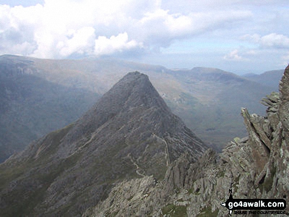
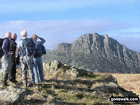
165. Tryfan
915m (3,003ft)
Mountain (15th in Wales, 21st in England & Wales)
Nuttall (16th in Wales, 24th in England & Wales)
Marilyn (6th in Wales, 212th in GB)
To walk, climb & bag Tryfan use either of these easy to follow walks:
See the location of Tryfan and walks up it on a google MapTryfan is on interactive maps:
OS Explorer (Orange Covers): OL17
OS Landranger (Pink Covers): 115
Tryfan is on Peak Bagging Map and Hill Tick List:
|
166. Twmpa (Lord Hereford's Knob)
690m (2,264ft)
Mountain (72nd in Wales, 183rd in England & Wales)
Nuttall (93rd in Wales, 237th in England & Wales)
To walk, climb & bag Twmpa (Lord Hereford's Knob) use any of these easy to follow walks:
See the location of Twmpa (Lord Hereford's Knob) and walks up it on a google MapTwmpa (Lord Hereford's Knob) is on interactive maps:
OS Explorer (Orange Covers): OL13
OS Landranger (Pink Covers): 161
Twmpa (Lord Hereford's Knob) is on Peak Bagging Map and Hill Tick List:
|
167. Tyrrau Mawr (Craig-las)
661m (2,169ft)
Mountain (96th in Wales, 231st in England & Wales)
Nuttall (128th in Wales, 308th in England & Wales)
To walk, climb & bag Tyrrau Mawr (Craig-las) use either of these easy to follow walks:
See the location of Tyrrau Mawr (Craig-las) and walks up it on a google MapTyrrau Mawr (Craig-las) is on interactive maps:
OS Explorer (Orange Covers): OL23
OS Landranger (Pink Covers): 124
Tyrrau Mawr (Craig-las) is on Peak Bagging Map and Hill Tick List:
|
168. Waun Camddwr
621m (2,040ft)
Nuttall (170th in Wales, 399th in England & Wales)
To walk, climb & bag Waun Camddwr use this easy to follow walk:
See the location of Waun Camddwr and walks up it on a google MapWaun Camddwr is on interactive maps:
OS Explorer (Orange Covers): OL23
OS Landranger (Pink Covers): 125
Waun Camddwr is on Peak Bagging Map and Hill Tick List:
|
169. Waun Fach
811m (2,662ft)
Mountain (32nd in Wales, 69th in England & Wales)
Nuttall (40th in Wales, 83rd in England & Wales)
Marilyn (14th in Wales, 368th in GB)
OS Trig Point
To walk, climb & bag Waun Fach use either of these easy to follow walks:
See the location of Waun Fach and walks up it on a google MapWaun Fach is on interactive maps:
OS Explorer (Orange Covers): OL13
OS Landranger (Pink Covers): 161
Waun Fach is on Peak Bagging Map and Hill Tick List:
|
170. Waun Garnedd-y-Filiast
650m (2,136ft)
Nuttall (139th in Wales, 330th in England & Wales)
To walk, climb & bag Waun Garnedd-y-Filiast use either of these easy to follow walks:
See the location of Waun Garnedd-y-Filiast and walks up it on a google MapWaun Garnedd-y-Filiast is on interactive maps:
OS Explorer (Orange Covers): OL18
OS Landranger (Pink Covers): 124 and
125
Waun Garnedd-y-Filiast is on Peak Bagging Map and Hill Tick List:
|
171. Waun Lefrith (Bannau Sir Gaer)
677m (2,221ft)
Nuttall (110th in Wales, 264th in England & Wales)
To walk, climb & bag Waun Lefrith (Bannau Sir Gaer) use any of these easy to follow walks:
See the location of Waun Lefrith (Bannau Sir Gaer) and walks up it on a google MapWaun Lefrith (Bannau Sir Gaer) is on interactive maps:
OS Explorer (Orange Covers): OL12
OS Landranger (Pink Covers): 160
Waun Lefrith (Bannau Sir Gaer) is on Peak Bagging Map and Hill Tick List:
|
172. Waun Rydd
769m (2,524ft)
Mountain (44th in Wales, 105th in England & Wales)
Nuttall (55th in Wales, 129th in England & Wales)
Marilyn (20th in Wales, 452nd in GB)
OS Trig Point
To walk, climb & bag Waun Rydd use any of these easy to follow walks:
See the location of Waun Rydd and walks up it on a google MapWaun Rydd is on interactive maps:
OS Explorer (Orange Covers): OL12
OS Landranger (Pink Covers): 160
Waun Rydd is on Peak Bagging Map and Hill Tick List:
|
173. Waun-oer
670m (2,198ft)
Mountain (87th in Wales, 215th in England & Wales)
Nuttall (116th in Wales, 286th in England & Wales)
OS Trig Point
To walk, climb & bag Waun-oer use either of these easy to follow walks:
See the location of Waun-oer and walks up it on a google MapWaun-oer is on interactive maps:
OS Explorer (Orange Covers): OL23
OS Landranger (Pink Covers): 124
Waun-oer is on Peak Bagging Map and Hill Tick List:
|
174. Y Foel Goch
805m (2,642ft)
Mountain (33rd in Wales, 72nd in England & Wales)
Nuttall (42nd in Wales, 87th in England & Wales)
To walk, climb & bag Y Foel Goch use either of these easy to follow walks:
See the location of Y Foel Goch and walks up it on a google MapY Foel Goch is on interactive maps:
OS Explorer (Orange Covers): OL17
OS Landranger (Pink Covers): 115
Y Foel Goch is on Peak Bagging Map and Hill Tick List:
|
175. Y Garn (Glyderau)
947m (3,108ft)
Mountain (10th in Wales, 13th in England & Wales)
Nuttall (11th in Wales, 15th in England & Wales)
Marilyn (4th in Wales, 167th in GB)
To walk, climb & bag Y Garn (Glyderau) use any of these easy to follow walks:
See the location of Y Garn (Glyderau) and walks up it on a google MapY Garn (Glyderau) is on interactive maps:
OS Explorer (Orange Covers): OL17
OS Landranger (Pink Covers): 115
Y Garn (Glyderau) is on Peak Bagging Map and Hill Tick List:
|
176. Y Garn (Moel Hebog)
633m (2,078ft)
Nuttall (152nd in Wales, 363rd in England & Wales)
To walk, climb & bag Y Garn (Moel Hebog) use any of these easy to follow walks:
See the location of Y Garn (Moel Hebog) and walks up it on a google MapY Garn (Moel Hebog) is on interactive maps:
OS Explorer (Orange Covers): OL17
OS Landranger (Pink Covers): 115
Y Garn (Moel Hebog) is on Peak Bagging Map and Hill Tick List:
|
177. Y Garn (Pumlumon)
684m (2,245ft)
Mountain (78th in Wales, 191st in England & Wales)
Nuttall (102nd in Wales, 250th in England & Wales)
To walk, climb & bag Y Garn (Pumlumon) use this easy to follow walk:
See the location of Y Garn (Pumlumon) and walks up it on a google MapY Garn (Pumlumon) is on interactive maps:
OS Explorer (Orange Covers): 213
OS Landranger (Pink Covers): 135
A go4awalk.com Peak Bagging Map and Hill Tick List featuring Y Garn (Pumlumon) will be available soon. |
178. Y Garn (Rhinogs)
629m (2,064ft)
Mountain (117th in Wales, 278th in England & Wales)
Nuttall (161st in Wales, 376th in England & Wales)
Marilyn (49th in Wales, 717th in GB)
To walk, climb & bag Y Garn (Rhinogs) use this easy to follow walk:
See the location of Y Garn (Rhinogs) and walks up it on a google MapY Garn (Rhinogs) is on interactive maps:
OS Explorer (Orange Covers): OL18
OS Landranger (Pink Covers): 124
Y Garn (Rhinogs) is on Peak Bagging Map and Hill Tick List:
|
179. Y Groes Fagl
659m (2,163ft)
Nuttall (131st in Wales, 312th in England & Wales)
To walk, climb & bag Y Groes Fagl use either of these easy to follow walks:
See the location of Y Groes Fagl and walks up it on a google MapY Groes Fagl is on interactive maps:
OS Explorer (Orange Covers): 255
OS Landranger (Pink Covers): 125
Y Groes Fagl is on Peak Bagging Map and Hill Tick List:
|
180. Y Gyrn
619m (2,032ft)
Nuttall (174th in Wales, 409th in England & Wales)
To walk, climb & bag Y Gyrn use either of these easy to follow walks:
See the location of Y Gyrn and walks up it on a google MapY Gyrn is on interactive maps:
OS Explorer (Orange Covers): OL12
OS Landranger (Pink Covers): 160
Y Gyrn is on Peak Bagging Map and Hill Tick List:
|
Page 6 of 7 Go to page:
1 2 3 4 5 6 7 |
View all 735 Mountains, Peaks, Tops and Hills in WalesThe Brecon Beacons:
Is there a Mountain, Peak, Top or Hill missing from the above google map or list?
Let us know an we will add it to our database.

 Snowdon (Yr Wyddfa) the highest point in The Brecon Beacons AreaWales


