All the Mountains, Peaks, Tops and Hills in England, England as a detailed list
England is defined as the whole of the country of England which includes the National Parks of Dartmoor, Exmoor, The Lake District, The Peak District, The North York Moors, Northumberland, The South Downs and The Yorkshire Dales, as well as The Chilterns, The Cotswolds, The Forest of Bowland, The North Peninnes, The Shropshire Hills and The South Peninnes.
If you count only the Marilyns there are 174 tops to climb, bag & conquer and the highest point is Scafell Pike at 978m (3,210ft).
To see all Mountains, Peaks, Tops and Hills displayed in different ways - see the options in the left-hand column and towards the bottom of this page.
LOG ON and RELOAD this page to show which Mountains, Peaks, Tops and Hills you have already climbed, bagged & conquered [. . . more]
Page 2 of 6 Go to page:
1 2 3 4 5 6 |
See this list in: Alphabetical Order‡
| Height Order
To reverse the order select the link again.
Mountain, Peak, Top or Hill:
Bagged
31. Carnmenellis
252m (827ft)
Marilyn (154th in England, 1460th in GB)
OS Trig Point
We hope to have walks that climb & bag Carnmenellis very soon
See the location of Carnmenellis and walks up it on a google MapCarnmenellis is on interactive maps:
OS Explorer (Orange Covers): 104
OS Landranger (Pink Covers): 203
|
32. Chanctonbury Ring (Chanctonbury Hill)
238m (781ft)
Marilyn (161st in England, 1483rd in GB)
OS Trig Point
We hope to have walks that climb & bag Chanctonbury Ring (Chanctonbury Hill) very soon
See the location of Chanctonbury Ring (Chanctonbury Hill) and walks up it on a google MapChanctonbury Ring (Chanctonbury Hill) is on interactive maps:
OS Explorer (Orange Covers): 121
OS Landranger (Pink Covers): 198
A go4awalk.com Peak Bagging Map and Hill Tick List featuring Chanctonbury Ring (Chanctonbury Hill) will be available soon. |
33. Christ Cross
261m (856ft)
Marilyn (151st in England, 1449th in GB)
OS Trig Point
We hope to have walks that climb & bag Christ Cross very soon
See the location of Christ Cross and walks up it on a google MapChrist Cross is on interactive maps:
OS Explorer (Orange Covers): 114
OS Landranger (Pink Covers): 192
|
34. Claife Heights (High Blind How)
270m (886ft)
Wainwright Outlying Fell (No. 83)
Marilyn (147th in England, 1433rd in GB)
OS Trig Point
To walk, climb & bag Claife Heights (High Blind How) use this easy to follow walk:
See the location of Claife Heights (High Blind How) and walks up it on a google MapClaife Heights (High Blind How) is on interactive maps:
OS Explorer (Orange Covers): OL7
OS Landranger (Pink Covers): 96 and
97
A go4awalk.com Peak Bagging Map and Hill Tick List featuring Claife Heights (High Blind How) will be available soon. |
35. Cleeve Hill
330m (1,083ft)
Marilyn (117th in England, 1329th in GB)
OS Trig Point
Cleeve Hill is the highest point in the county of Gloucestershire.
We hope to have walks that climb & bag Cleeve Hill very soon
See the location of Cleeve Hill and walks up it on a google MapCleeve Hill is on interactive maps:
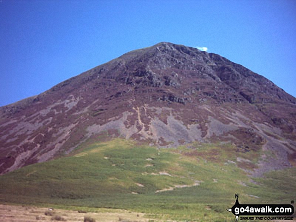
OS Explorer (Orange Covers): 179
OS Landranger (Pink Covers): 163
|
36. Cliffe Hill
164m (538ft)
Marilyn (174th in England, 1552nd in GB)
OS Trig Point
We hope to have walks that climb & bag Cliffe Hill very soon
See the location of Cliffe Hill and walks up it on a google MapCliffe Hill is on interactive maps:
OS Explorer (Orange Covers): OL11 and
OL25
OS Landranger (Pink Covers): 198
A go4awalk.com Peak Bagging Map and Hill Tick List featuring Cliffe Hill will be available soon. |
37. Cold Fell Pike (Geltsdale)
621m (2,038ft)
Mountain (167th in England, 290th in England & Wales)
Nuttall (230th in England, 400th in England & Wales)
Marilyn (48th in England, 725th in GB)
OS Trig Point
To walk, climb & bag Cold Fell Pike (Geltsdale) use either of these easy to follow walks:
See the location of Cold Fell Pike (Geltsdale) and walks up it on a google MapCold Fell Pike (Geltsdale) is on interactive maps:
OS Explorer (Orange Covers): OL31
OS Landranger (Pink Covers): 86
Cold Fell Pike (Geltsdale) is on Peak Bagging Map and Hill Tick List:
|
38. Cracoe Fell
507m (1,663ft)
Dewey (168th in England, 390th in England & Wales)
Marilyn (76th in England, 977th in GB)
OS Trig Point
To walk, climb & bag Cracoe Fell use this easy to follow walk:
See the location of Cracoe Fell and walks up it on a google MapCracoe Fell is on interactive maps:
OS Explorer (Orange Covers): OL2
OS Landranger (Pink Covers): 103
Cracoe Fell is on Peak Bagging Map and Hill Tick List:
|
39. Cringle Moor (Drake Howe)
434m (1,424ft)
Marilyn (91st in England, 1138th in GB)
We hope to have walks that climb & bag Cringle Moor (Drake Howe) very soon
See the location of Cringle Moor (Drake Howe) and walks up it on a google MapCringle Moor (Drake Howe) is on interactive maps:
OS Explorer (Orange Covers): OL26
OS Landranger (Pink Covers): 93
A go4awalk.com Peak Bagging Map and Hill Tick List featuring Cringle Moor (Drake Howe) will be available soon. |
40. Cross Fell
893m (2,931ft)
Mountain (10th in England, 28th in England & Wales)
Nuttall (12th in England, 30th in England & Wales)
Marilyn (5th in England, 248th in GB)
OS Trig Point
To walk, climb & bag Cross Fell use either of these easy to follow walks:
See the location of Cross Fell and walks up it on a google MapCross Fell is on interactive maps:
OS Explorer (Orange Covers): OL31
OS Landranger (Pink Covers): 91
Cross Fell is on Peak Bagging Map and Hill Tick List:
|
41. Crowborough
242m (794ft)
Marilyn (159th in England, 1478th in GB)
OS Trig Point
We hope to have walks that climb & bag Crowborough very soon
See the location of Crowborough and walks up it on a google MapCrowborough is on interactive maps:
OS Explorer (Orange Covers): 135
OS Landranger (Pink Covers): 188
A go4awalk.com Peak Bagging Map and Hill Tick List featuring Crowborough will be available soon. |
42. Dale Head (Newlands)
753m (2,471ft)
Wainwright (No. 63)
Mountain (68th in England, 117th in England & Wales)
Nuttall (84th in England, 144th in England & Wales)
Marilyn (21st in England, 477th in GB)
To walk, climb & bag Dale Head (Newlands) use any of these easy to follow walks:
See the location of Dale Head (Newlands) and walks up it on a google MapDale Head (Newlands) is on interactive maps:
OS Explorer (Orange Covers): OL4
OS Landranger (Pink Covers): 89 and
90
Dale Head (Newlands) is on Peak Bagging Map and Hill Tick List:
*Version including the walk routes marked on it that you need to follow to Walk all 214 Wainwrights in just 59 walks. |
43. Dent (Long Barrow)
352m (1,155ft)
Wainwright Outlying Fell (No. 59)
Marilyn (108th in England, 1297th in GB)
To walk, climb & bag Dent (Long Barrow) use this easy to follow walk:
See the location of Dent (Long Barrow) and walks up it on a google MapDent (Long Barrow) is on interactive maps:
OS Explorer (Orange Covers): OL4
OS Landranger (Pink Covers): 89
Dent (Long Barrow) is on Peak Bagging Map and Hill Tick List:
*Version including the walk routes marked on it that you need to follow to Walk all 214 Wainwrights in just 59 walks. |
44. Ditchling Beacon
248m (813ft)
Marilyn (156th in England, 1474th in GB)
OS Trig Point
Ditchling Beacon is the highest point in the county of East Sussex.
To walk, climb & bag Ditchling Beacon use either of these easy to follow walks:
See the location of Ditchling Beacon and walks up it on a google MapDitchling Beacon is on interactive maps:
OS Explorer (Orange Covers): OL11
OS Landranger (Pink Covers): 198
A go4awalk.com Peak Bagging Map and Hill Tick List featuring Ditchling Beacon will be available soon. |
45. Dodd Fell Hill
668m (2,192ft)
Mountain (128th in England, 218th in England & Wales)
Nuttall (171st in England, 289th in England & Wales)
Marilyn (40th in England, 655th in GB)
OS Trig Point
To walk, climb & bag Dodd Fell Hill use this easy to follow walk:
See the location of Dodd Fell Hill and walks up it on a google MapDodd Fell Hill is on interactive maps:
OS Explorer (Orange Covers): OL2 and
OL30
OS Landranger (Pink Covers): 98
Dodd Fell Hill is on Peak Bagging Map and Hill Tick List:
|
46. Dufton Pike
481m (1,579ft)
Marilyn (81st in England, 1025th in GB)
To walk, climb & bag Dufton Pike use either of these easy to follow walks:
See the location of Dufton Pike and walks up it on a google MapDufton Pike is on interactive maps:
OS Explorer (Orange Covers): OL19
OS Landranger (Pink Covers): 91
Dufton Pike is on Peak Bagging Map and Hill Tick List:
|
47. Dundry (Dundry Down)
233m (764ft)
Marilyn (162nd in England, 1486th in GB)
OS Trig Point
We hope to have walks that climb & bag Dundry (Dundry Down) very soon
See the location of Dundry (Dundry Down) and walks up it on a google MapDundry (Dundry Down) is on interactive maps:
OS Explorer (Orange Covers): 154 and
155
OS Landranger (Pink Covers): 172 and
182
|
48. Dunkery Beacon
519m (1,703ft)
Dewey (140th in England, 319th in England & Wales)
Marilyn (72nd in England, 940th in GB)
OS Trig Point
Dunkery Beacon is the highest point in the county of Somerset.
To walk, climb & bag Dunkery Beacon use either of these easy to follow walks:
See the location of Dunkery Beacon and walks up it on a google MapDunkery Beacon is on interactive maps:
OS Explorer (Orange Covers): OL9
OS Landranger (Pink Covers): 181
A go4awalk.com Peak Bagging Map and Hill Tick List featuring Dunkery Beacon will be available soon. |
49. Easington Fell
396m (1,300ft)
Marilyn (98th in England, 1213th in GB)
To walk, climb & bag Easington Fell use this easy to follow walk:
See the location of Easington Fell and walks up it on a google MapEasington Fell is on interactive maps:
OS Explorer (Orange Covers): OL41
OS Landranger (Pink Covers): 103
Easington Fell is on Peak Bagging Map and Hill Tick List:
|
50. Fair Snape Fell
520m (1,706ft)
Dewey (138th in England, 317th in England & Wales)
Marilyn (70th in England, 937th in GB)
To walk, climb & bag Fair Snape Fell use any of these easy to follow walks:
See the location of Fair Snape Fell and walks up it on a google MapFair Snape Fell is on interactive maps:
OS Explorer (Orange Covers): OL41
OS Landranger (Pink Covers): 102
Fair Snape Fell is on Peak Bagging Map and Hill Tick List:
|
51. Fairfield
873m (2,865ft)
Wainwright (No. 13)
Mountain (15th in England, 35th in England & Wales)
Nuttall (18th in England, 40th in England & Wales)
Marilyn (7th in England, 280th in GB)
To walk, climb & bag Fairfield use any of these easy to follow walks:
See the location of Fairfield and walks up it on a google MapFairfield is on interactive maps:
OS Explorer (Orange Covers): OL5
OS Landranger (Pink Covers): 90
Fairfield is on Peak Bagging Map and Hill Tick List:
*Version including the walk routes marked on it that you need to follow to Walk all 214 Wainwrights in just 59 walks. |
52. Firle Beacon
217m (712ft)
Marilyn (164th in England, 1502nd in GB)
OS Trig Point
To walk, climb & bag Firle Beacon use this easy to follow walk:
See the location of Firle Beacon and walks up it on a google MapFirle Beacon is on interactive maps:
OS Explorer (Orange Covers): OL25
OS Landranger (Pink Covers): 198
A go4awalk.com Peak Bagging Map and Hill Tick List featuring Firle Beacon will be available soon. |
53. Fountains Fell
668m (2,192ft)
Mountain (129th in England, 220th in England & Wales)
Nuttall (172nd in England, 292nd in England & Wales)
Marilyn (41st in England, 657th in GB)
To walk, climb & bag Fountains Fell use this easy to follow walk:
See the location of Fountains Fell and walks up it on a google MapFountains Fell is on interactive maps:
OS Explorer (Orange Covers): OL2
OS Landranger (Pink Covers): 98
Fountains Fell is on Peak Bagging Map and Hill Tick List:
|
54. Freeholds Top
455m (1,493ft)
Marilyn (86th in England, 1095th in GB)
OS Trig Point
We hope to have walks that climb & bag Freeholds Top very soon
See the location of Freeholds Top and walks up it on a google MapFreeholds Top is on interactive maps:
OS Explorer (Orange Covers): OL21
OS Landranger (Pink Covers): 103
Freeholds Top is on Peak Bagging Map and Hill Tick List:
|
55. Garway Hill
366m (1,201ft)
Marilyn (104th in England, 1275th in GB)
OS Trig Point
We hope to have walks that climb & bag Garway Hill very soon
See the location of Garway Hill and walks up it on a google MapGarway Hill is on interactive maps:
OS Explorer (Orange Covers): 189
OS Landranger (Pink Covers): 161
|
56. Gisborough Moor
328m (1,076ft)
Marilyn (119th in England, 1334th in GB)
Gisborough Moor is the highest point in the county of Redcar and Cleveland.
We hope to have walks that climb & bag Gisborough Moor very soon
See the location of Gisborough Moor and walks up it on a google MapGisborough Moor is on interactive maps:
OS Explorer (Orange Covers): OL26
OS Landranger (Pink Covers): 94
A go4awalk.com Peak Bagging Map and Hill Tick List featuring Gisborough Moor will be available soon. |
57. Grasmoor
851m (2,794ft)
Wainwright (No. 20)
Mountain (23rd in England, 47th in England & Wales)
Nuttall (28th in England, 55th in England & Wales)
Marilyn (9th in England, 313th in GB)
To walk, climb & bag Grasmoor use any of these easy to follow walks:
See the location of Grasmoor and walks up it on a google MapGrasmoor is on interactive maps:
OS Explorer (Orange Covers): OL4
OS Landranger (Pink Covers): 89 and
90
Grasmoor is on Peak Bagging Map and Hill Tick List:
*Version including the walk routes marked on it that you need to follow to Walk all 214 Wainwrights in just 59 walks. |
58. Grayrigg Forest
494m (1,621ft)
Marilyn (80th in England, 994th in GB)
OS Trig Point
To walk, climb & bag Grayrigg Forest use this easy to follow walk:
See the location of Grayrigg Forest and walks up it on a google MapGrayrigg Forest is on interactive maps:
OS Explorer (Orange Covers): OL7
OS Landranger (Pink Covers): 97
A go4awalk.com Peak Bagging Map and Hill Tick List featuring Grayrigg Forest will be available soon. |
59. Great Coum
687m (2,254ft)
Mountain (111th in England, 187th in England & Wales)
Nuttall (146th in England, 245th in England & Wales)
Marilyn (35th in England, 619th in GB)
To walk, climb & bag Great Coum use this easy to follow walk:
See the location of Great Coum and walks up it on a google MapGreat Coum is on interactive maps:
OS Explorer (Orange Covers): OL2
OS Landranger (Pink Covers): 98
Great Coum is on Peak Bagging Map and Hill Tick List:
|
60. Great Gable
899m (2,951ft)
Wainwright (No. 7)
Mountain (9th in England, 25th in England & Wales)
Nuttall (11th in England, 28th in England & Wales)
Marilyn (4th in England, 238th in GB)
To walk, climb & bag Great Gable use any of these easy to follow walks:
See the location of Great Gable and walks up it on a google MapGreat Gable is on interactive maps:
OS Explorer (Orange Covers): OL4
OS Landranger (Pink Covers): 89 and
90
Great Gable is on Peak Bagging Map and Hill Tick List:
*Version including the walk routes marked on it that you need to follow to Walk all 214 Wainwrights in just 59 walks. |
Page 2 of 6 Go to page:
1 2 3 4 5 6 |
View all 1233 Mountains, Peaks, Tops and Hills in EnglandThe Lake District:
Is there a Mountain, Peak, Top or Hill missing from the above google map or list?
Let us know an we will add it to our database.

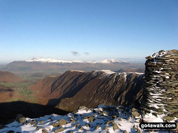
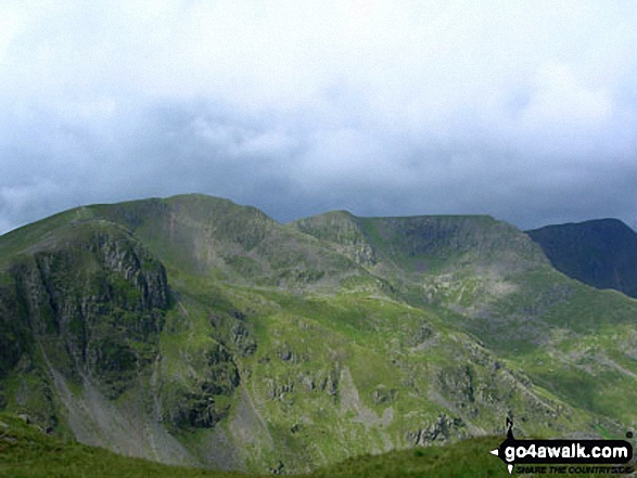
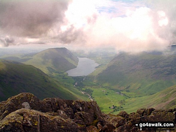
 The view from Scafell Pike, the highest point in England


