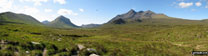
Walk Photographs and views from British Walks published during 2007

Kinder Downfall with Kinder Reservoir beyond


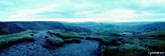
Cross Dyke from Townbrook Valley, The Long Mynd

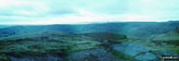
Caer Caradoc Hill from Ashlet, The Long Mynd

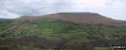
Little Stretton from Ashlet, The Long Mynd

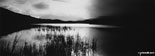
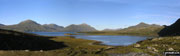
Early morning mist catches the low light on Crummock Water with the towering Grasmoor beyond

The Loweswater Fells from Mellbreak

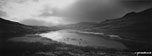
Whiteside (left) and Grasmoor from Crummock Water


Sca Fell (centre), Mickledore and Scafell Pike (right) from Crinkle Crags

Looking North from the summit of Shutlingsloe


Katherine Arzul and her dog Millie at John O'Groats

Looking West from the summit of High Street

Helvellyn and Swirral Edge (top right) from Red Tarn (Helvellyn)


West Nab summit Trig Point, Meltham Moor


Lindley Moor summit trig point

Spiders Web with Hoarfrost on Lindley Moor


Fairfield and Seat Sandal from The Wythburn Fells

The footbridge carrying The Coast to Coast walk over Swinner Gill near Keld

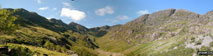
The Lost Valley , tucked away between Aonach Dubh and Gearr Aonach (2 of the 3 sisters of Glen Coe)
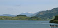
Ben Nevis beyond Loch Sunart from near Strontian

Striding Edge and Red Tarn (Helvellyn) from the summit of Helvellyn


The famous view of Striding Edge from Helvellyn


The Sirhowy River, Sirhowy Valley Country Park

The Sirhowy River, Sirhowy Valley Country Park

View from Sirhowy Valley Country Park

View from Sirhowy Valley Country Park

View from Sirhowy Valley Country Park

The Sirhowy River, Sirhowy Valley Country Park

The Sirhowy River, Sirhowy Valley Country Park

View from Sirhowy Valley Country Park

The Sirhowy River, Sirhowy Valley Country Park

View from Sirhowy Valley Country Park

The Sirhowy River, Sirhowy Valley Country Park


The North Tees Oil Terminal from Eston Nab (Eston Moor)

Eston Nab (Eston Moor) summit furniture

Black Law (Ettrick Forest) summit trig point

Minto from Minto Hill (Minto Hills) summit trig point

Ill Bell and Froswick from Sleddale Forest

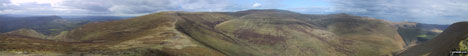
The Howgill Fells from Ulgraves (Potter Fell)

Sca Fell and Scafell Pike from Ulgraves (Potter Fell)

Barf from Powter How, Bassenthwaite Lake

Rock formations on Stiperstones (Manstone Rock)


Pen y Fan (far left) and Corn Du with Llyn Cwm Llwch tarn below from near the Tommy Jones Obelisk


Little Moreton Hall entrance drive in autumn
North from the summit of Bow Fell (Bowfell)
Great Knott from Red Tarn (Langdale)


Buachaille Etive Beag (Stob Dubh) from Lairig Eilde

Looking South West from the highest point of Lairig Eilde

Looking South West from the highest point of Lairig Eilde

Looking South West from the highest point of Lairig Eilde

Troutbeck from the path beside Hagg Gill on the East side of Troutbeck Tongue


Derwent Water with Walla Crag beyond from Hawes End Pier

Mucker Valley taken from about half way down Great Shunner Fell

Early evening in Wenslydale seen from the campsite at Bainbridge Ings near Hawes


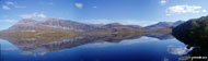
Lock Katrine from the summit of Ben A'an

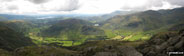
Great Langdale from Oxendale Beck

The Band with two of The Langdale Pikes (Pike of Stickle and Loft Crag) beyond from Oxendale

Pike of Blisco (Pike o' Blisco) from Oxendale


Dufton Pike and Knock Pike (right)


Stool End Farm, Langdale with Pike of Stickle rising majestically


Rydal Water and Loughrigg Fell from the Dove Cottage to Rydal Path


Temperature inversion in the Upper Derwent Valley seen from Rowlee Pasture

Temperature inversion in the Upper Derwent Valley seen from Rowlee Pasture

Alport Castles, Rowlee Pasture

Temperature inversion in the Upper Derwent Valley seen from Rowlee Pasture


Arkengarthdale from Fremington Edge


A lone tree on Fremington Edge

Old Kiln workings on Fremington Edge

Old Kiln workings on Fremington Edge

Old stone barn on Fremington Edge

A bird in a tree on Fremington Edge

Reeth Bridge where it crosses Arkle Beck in Fremington

Arkle Beck from beneath Reeth Bridge


Woodland above Mill Gill near Askrigg


Whitfield Scar from woodland above Mill Gill near Askrigg


Views on the Cwmcarn Forest Drive

Views on the Cwmcarn Forest Drive

Views on the Cwmcarn Forest Drive

Views on the Cwmcarn Forest Drive

Views on the Cwmcarn Forest Drive

Views on the Cwmcarn Forest Drive

Tryfan and The Glyderau (Glyderau) from Cwm Tal-y-Braich below Pen Llithrig y Wrach

Bwlch Eryl Farchog from Pen yr Helgi Du

Pen yr Helgi Du from Pen Llithrig y Wrach


Musicians on the summit of Helvellyn

Musicians on the summit of Helvellyn

Musicians on the summit of Helvellyn

Musicians on the summit of Helvellyn


Crag Lough and Hadrian's Wall from Hotbank

On Hadrian's Wall between Hotbank and Housesteads

At a milecastle on Hadrian's Wall between Hotbank and Housesteads

On Stable Stones Brow (Hoarstone Edge) looking over Dovestone Reservoir to Alphin Pike
2.jpg)
3.jpg)
4.jpg)
Stoney Middleton, The River Derwent and Curbar from Curbar Edge
5.jpg)


Looking down Jaggers Clough from The Kinder Plateau (Edale Moor)

South Head and Mount Famine from near Edale Cross


Rock slabs above Twll Du (The Devil's Kitchen)


Pen yr Ole Wen from Llyn y Cwm on Cwm Idwal

The Glyderau (Glyderau) poking up through the clouds from the summit of Carnedd Moel Siabod


Climbing the North West ridge of Carnedd Moel Siabod

Elidir Fawr from Mynydd Perfedd

Llyn Ogwen, Tryfan and Lynn Idwal from Y Garn (Glyderau)


Sunrise over Great Langdale taken close by Dungeon Ghyll below the summit of Harrison Stickle

Sunrise over Great Langdale taken close by Dungeon Ghyll below the summit of Harrison Stickle


The Pennine Way sign on the summit of Pen-y-ghent


Fremington Edge and Arkengarthdale from near Booze

The Ribblehead Viaduct with the huge bulk of Wernside beyond from near God's Bridge
*The south west side of Arkle from Loch Stack


Froswick and Thronthwaite Crag beyond Kentmere Reservoir from Kentmere Pike

Harter Fell from near Kentmere Pike

Kentmere Pike from Gatescarth Pass

Kentmere Reservoir from Kentmere Pike


Hardwicke Brook on The Wye Valley Walk near Hay-on-Wye (Y Gelli Gandryll)

Winter Evening at Castlerigg Stone Circle


The Langdale Pikes from the summit of Pike of Blisco (Pike o' Blisco)

Snowdon (Yr Wyddfa) and Llyn Gaslyn from Crib Goch

Euan Foster celebrates 'bagging' Ben Nevis

Approaching the summit of Ben Nevis


Heading towards The Devil's Ladder with Carrauntoohil to the right

The steel cross on the summit of Carrauntoohil


Pen-y-ghent from Brackenbottom


Pen-y-ghent from The Pennine Way above Dale Head

Pen-y-ghent from the Pennine Way near Hull Pot


Buttermere from near Blackbeck Tarn - a path travelled


My partner Fiona on Stob Diamh
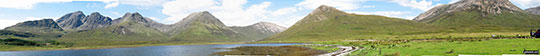

Bla Bheinn (Blaven) (South West Top) and Bla Bheinn (Blaven) from Loch Slapin near Torrin

Garbh-bheinn (Skye) and Belig from Loch Slapin near Torrin

Glas Bheinn Mhor (Skye) from Loch Slapin near Torrin

Beinn na Cro from Loch Slapin near Torrin

Beinn Dearg Mheadhonach (Skye) from Glen Sligachan near the Sligachan Hote

Marsco from Glen Sligachan near the Sligachan Hotel

Sgurr nan Gillean, Am Basteir and Bruach na Frithe from Glen Sligachan near the Sligachan Hote
*Sgurr Thuilm (Sgurr a' Mhadaidh) with Bruach na Frithe and Am Bastier beyond from Glen Brittle

Bruach na Frithe and Am Bastier beyond from Glen Brittle

Sgurr Thuilm (Sgurr a' Mhadaidh) from Glen Brittle

Slat Bheinn from Loch Slapin near Torrin

Me and a climbing friend on The Cairnwell


Me and Mackie on Ben More (Mull)

On Ben Macdui (Beinn MacDuibh)

Me and Dougie Meiklejohn on Ben Macdui (Beinn MacDuibh)

On Ben Macdui (Beinn MacDuibh)


Callaum 'big Jesse' on Lochnagar (Cac Carn Beag)

Frank on Ben Vorlich (The Arrochar Alps)

Gregor Wright on Ladhar Bheinn

My best friend Steve on the last steps to the top of The Cobbler (Ben Arthur)

Me, my other half and 2 work colleagues on Mount Keen

My family on Lochnagar (Cac Carn Beag)

Me and my friend Claire on Carn a' Gheoidh

Winter on Cairn Lochan (Cairn Gorm)

'Prime Time' ramblers on Lochnagar (Cac Carn Beag)


On the summit of A' Chraileag (A' Chralaig)


On An Teallach (Bidein a' Ghlas Thuil)


Waun Fach from the summit cairn on Pen y Gadair Fawr


Crummock Water from Low Fell's south top

Looking up Longsleddale from Sadgill

The southern slopes of Yewbarrow and the Scafell massif from Nether Beck

Swirling mist clearing the ridge on Red Pike (Wasdale) from Steeple


The Pentland Hills from Penvalla


Harter Fell from the River Rawthey Valley just south of Cautley

Yarlside from The River Rawthey near Narthwaite Farm

Potts Valley from Crosby Garrett Fell

The summit of Nettle Hill is the highest point of Crosby Garrett Fell (a.k.a. Beacon Hill)

Smardale Bridge from Wainwright's Coast to Coast Walk just North of Newbiggin-on-Lune

Smardale Viaduct from Smardale

The west ridge of Beinn nan Aighenan

Glen Kinglass from Beinn nan Aighenan

On the summit of The Cobbler (Ben Arthur)

Approaching West Lomond, The Lomond Hills

Approaching the summit of Stac Gorm

Cautley Spout - the waterfall at the top of Black Force, Carlin Gill


1.jpg)

Looking back down to Loch Shiel and Glenfinnan from Sgurr Ghiubhsachain


The 200 steps of the Devil's Staircase

Caldon Canal at Froghall Wharf

The small lake nr Froghall Wharf

View South West from Foxt Village

*The Devils Dyke from Higher Shelf Stones

Sgorr na Ciche (Pap of Glen Coe) (left) and Mam na Guallain (right) and Loch Leven from Kinlochleven

*The Cuillin Hills (Isle of Skye) from the summit of An Sgurr (Eigg)

Beinn Fhada (Stob Coire Sgreamhach) from Coire Gabhail (The 'Lost Valley' of Glen Coe)

Stob Coire Sgreamhach from Coire Gabhail (The 'Lost Valley' of Glen Coe)

Bidean Nam Bian from Coire Gabhail (The 'Lost Valley' of Glen Coe)


Nearing the summit of Shutlingsloe

Ridgegate Reservoir, Macclesfield Forest

Trentabank Reservoir, Macclesfield Forest

Grasmere from Loughrigg Terrace

Heron Pike, Rydal Fell, Great Rigg and Fairfield from Loughrigg Terrace

On the summit of Loughrigg Fell, looking towards Elterwater with the Langdale Pikes to the right

Elterwater with The Coniston Fells beyond from Loughrigg Fell summit

Windermere from Loughrigg Fell summit

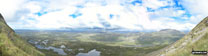
*360° Panoroma from the summit of Loughrigg Fell


The River Brathay at Skelwith Bridge

Skelwith Force near Skelwith Bridge

The River Brathay near Skelwith Bridge

On The Cumbria Way near Elterwater with The Langdale Pikes in the distance


Striding Edge basking in glorious September Sun viewed from Helvellyn


The Grwyne Fechan valley and Darren Fach from Pen Trumau

Mynydd Llysiau from Pen Trumau


Pen Trumau and Waun Fach from Mynydd Llysiau

The Grwyne Fechan valley from Mynydd Llysiau

Pen-y-Ghent from Horton in Ribblesdale Churchyard

Looking South from Pen-y-Ghent


Heading for Whernside from Ribblehead on The Yorkshire Three Peaks Challenge


Pen-y-ghent from Greensett Moss, Whernside

On Whernside summit during The Yorkshire Three Peaks Challenge


The zig-zag path to the ridge below Ingleborough


The long haul back to Horton in Ribblesdale from Ingleborough

Heron Pike from Glenridding Dodd

Glenridding Dodd from Heron Pike

Towards Helvellyn from Sheffield Pike

Ullswater from Sheffield Pike summit

Catstye Cam and The Glenridding Beck Valley from near Nick Head


Vale of Lorton viewed from the lower southern slopes of Graystones above Darling How Plantation

Brothers Water from the path below Brock Crags

Brock Crags from near the summit of Rest Dodd

Hartsop village from Gray Crag’s northern slope


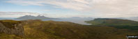
Looking down Loch Harport to the Cuillin Hills from Boust Hill

The mouth of the Ord River with the Cuillin Hills beyond


The Storr and The Old Man of Storr from across Loch Leathan


Sheringham from Sheringham Golf Course


The Poppy Line (Steam Railway), Sheringham


Approaching Heron Pike with Fairfield beyond

Derwent Water from Cat Bells (Catbells)

Ennerdale from Hay Stacks (Haystacks)

Hay Stacks (Haystacks) from Scarth Gap

Coniston Water from The Old Man of Coniston summit

Coniston Water from The Old Man of Coniston summit

Coniston Water from The Old Man of Coniston summit

On The Old Man of Coniston summit

Wasdale Head and Wast Water from Gavel Neese on the lower slopes of Great Gable

A rainbow over Bamford Moor from near to the top of Parkin Clough, Winhill Pike (Win Hill)

The Edale Valley from Jacob's Ladder (Edale)

The Kinder Plateau from Grindslow Knoll (Kinder Scout)

The Edale Valley from Grindslow Knoll (Kinder Scout)
*The Edale Valley and Kinder Plateau from Grindslow Knoll (Kinder Scout)
*Panoramic view from Grindslow Knoll (Kinder Scout)

At the bottom of Jacob's Ladder (Edale)

View from the top of Jacob's Ladder (Edale)

Kinder Scout from Kinder Reservoir

Looking West towards Bole Hill, Longshaw Country Park

View to lake on Longshaw Estate, Longshaw Country Park

Money Tree! - Burbage Woods, Longshaw Country Park

Bridge across Burbage Brook, Longshaw Country Park

View North To Higger Tor, Hathersage Moor, Longshaw Country Park

Climbing Harrison Stickle above Stickle Tarn in the Langdale Pikes


Nearing the summit of Simon's Seat

Me and my husband Michael on Bidein a'Ghlas Thuill (An Teallach)


On the Carn Mor Dearg (CMD) Arete


The Cannon on the North Ridge of Tryfan

Looking onto An Stuc (Ben Lawers) from Meall Garbh (Loch Tay)

Ruin on the Miners' Track, Snowdon (Yr Wyddfa)

Glaslyn, Llyn Llydaw and Y Lliwedd from the Miners' Track near the summit of Snowdon (Yr Wyddfa)

Llanberis from Snowdon (Yr Wyddfa)

The Miners' Track from the PYG Track, Snowdon (Yr Wyddfa)

Y Lliwedd (East Top) and Y Lliwedd from The Miners' Track near Llyn Llydaw

Sheep on Snowdon (Yr Wyddfa) with the Snowdon Mountain Railway beyond


Walking towards Cribyn from Pont y Caniedydd


The final ascent to Cribyn from the Bryn Teg ridge

Preparing to descend The Chancellor from Am Bodach (Aonach Eagach)

Descending Meall Dearg (Aonach Eagach) and the Aonach Eagach Ridge

Looking East along Glen Coe from the Clachaig Gully below Sgorr nam Fiannaidh (Aonach Eagach)

Looking west along the Aonach Eagach ridge at the Crazy Pinnacles from Meal Dearg (Aonach Eagach)

Brodick Bay from Goatfell (Goat Fell), The Isle fo Arran

The Isle fo Arran from The Firth of Clyde

Cir Mhor (left) and Caisteal Abhail (right) from Goatfell (Goat Fell), The Isle fo Arran

Cir Mhor (centre right) and Caisteal Abhail (right) from Glen Sannox, Isle of Arran

Beinn Bhreac (Arran) from Mullach Buidhe (Arran), Isle of Arran

Holy Island from Clauchland, Isle of Arran

Lochranza from across Loch Ranza

South from the summit of Ben Donich

On the North Ridge of Goatfell (Goat Fell) with Sannox and the Firth of Clyde beyond


Clach Leathad (Creise) (left), Stob a' Ghlais Choire (Creise) and Meall a Bhuiridh from Rannock Moor


Sunset over Ailsa Craig (Paddy's Milepost)


Ess-na-Crub Waterfall, Glenariff Forest Park

Ess-na-Larach Waterfall, Glenariff Forest Park

Lower Falls, Glenariff Forest Park

Fleetwith Pike from Hay Stacks (Haystacks)


Foel Cwm-Sian Llwyd trig point

Glasgwm summit just as the mist closed in

Glasgwm from Pen y Brynfforchog (aka Pen y Brynnfforchog)


Approaching Meall a' Bhuachaille

The summit of Meall a' Bhuachaille


Ben Wyvis (Glas Leathad Mor) from the cairn on Little Wyvis

An Cabar (Ben Wyvis) summit cairns

Ben Wyvis (Glas Leathad Mor) trig point and shelter

Ben Wyvis (Glas Leathad Mor) from Glas Leathad Beag (Ben Wyvis)

Tom a' Choinnich (Ben Wyvis) summit in mist

Sgurr Breac summit cairn in mist

Toman Coinich (A' Chailleach) summit cairn

A' Chailleach (Wester Ross) summit


Upper Cwm Bridge over Grwyne Fechan near Llanbedr

Table Mountain (on the South East shoulder of Pen Cerrig-calch) from Blaen-yr-henbant
Pen Cerrig-calch (with Table Mountain on the left hand lower slope) from Blaen-yr-henbant

The Grwyne Fechan valley from Darren Fach

Grwyne Fechan near Darren Fach

Waun Fach from Pen y Gadair Fawr

Pen y Gadair Fawr summit cairn

The summit of Pen y Gadair Fawr

Pen Cerrig-calch and The Grwyne Fechan valley from Blaen-yr-henbant

Waun Fach and Pen y Gadair Fawr from Crug Mawr


The Grwyne Fawr valley from Crug Mawr

Pen y Gadair Fawr from the Pen Twyn Mawr ridge

*Waun Fach and Pen y Gadair Fawr from the Pen Twyn Mawr ridge

Large cairn on the Pen Twyn Mawr ridge

Bal-Mawr and Mynydd Du Forest from Pen Twyn Mawr

Waun Fach from the Pen Twyn Mawr ridge


On The Cobbler (Ben Arthur) (NE Top)

On The Cobbler (Ben Arthur) (NE Top)


Rannoch Moor from Stob Ghabhar

Braeriach (Braigh Riabhach) summit during a break in the clouds


Carn Mor Dearg from Carn Dearg Meadhonach (Carn Mor Dearg)
To contribute to go4awalk.com or to contact us about anything at all - see Talk To Us.
For help see Help.
go4awalk.com and go4awalk.co.uk are registered trademarks of TMDH Limited.
Copyright © 2000-2026 TMDH Limited. All rights reserved.
Copyright Terms & Conditions Privacy Statement
A - Z Walks Home Log On/Accounts Photo Gallery Walk Ideas and Collections Fell Facts Hill Skills Walking Questions and Answers Your Stories News Competitions Product Reviews/Gear Tests Walking Gear Guides Peaks and Mountains Peak Bagging Find New Walking Friends Camping GPS Waypoints for Walking Contents Walk Search Talk To Us go4awalk.com Help Free Example Walks Newsletter


