23 easy-to-follow circular walk route maps of all grades in The Northern Dales Area of The Yorkshire Dales
The Northern Dales Area of The Yorkshire Dales National Park is the area:
- Within the National Park north of the A684 from Sedbergh to Leyburn via Hawes, Bainbridge and Aysgarth
- East of the A683 from Sedbergh to Brough via Kirkby Stephen
Tap/mouse over a coloured circle (1-3 easy walks, 4-6 moderate walks, 7-9 hard walks) and click to select.
You can use these checkboxes to show only the grades of walk you are interested in:-
Scroll down the list of walks below & click on each walk title (in blue) to locate it on the map above.
See this list of walks, routes & maps in:
Grade Order |
Length Order |
Time Order |
Walk Number or Start Location Order
NB. To reverse (toggle) this order, click Grade Order again
   |
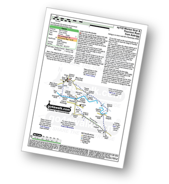
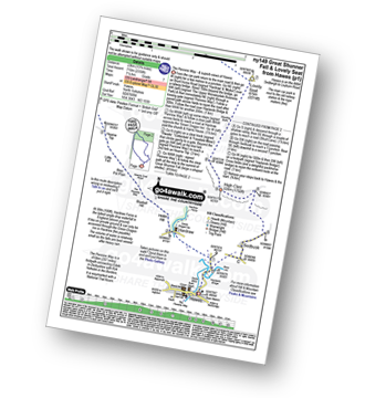
Vital Statistics:
| Length: | 6.25 miles (10 km) |
| Ascent: | 1,548ft (472m) |
| Time: | 3.75hrs |
| Grade: |  |
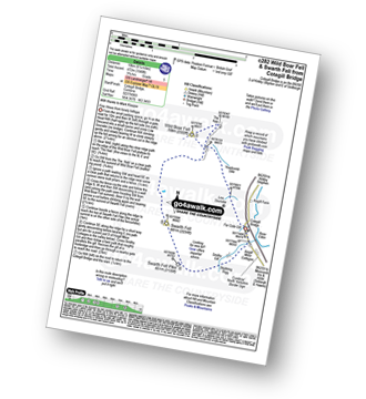
Route Summary:
Cotegill Bridge - Low Soursike - Yoadcomb Scar - Blackbed Scar - The Nab - Wild Boar Fell - High White Scar - The Band - Aisgill Head - Standard Brow - Swarth Fell - Swarth Fell Pike - Stubbing Rigg - Smithy Gill - Aisgill Moor Cottages - Cotegill Bridge
|
Vital Statistics:
| Length: | 8.5 miles (13.5 km) |
| Ascent: | 1,864ft (568m) |
| Time: | 5 hrs |
| Grade: |  |
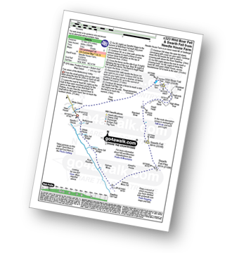
Route Summary:
Needle House Farm - Flint Howe - Sand Tarn - Sandtarn Riggs - Wild Boar Fell - Yoadcomb Scar - High White Scar - The Band (Wild Boar Fell) - Aisgill Head - Standard Brow - Swarth Fell - Swarth Fell Pike - Holmes Moss Hill - Rawthey Gil Foot - Holme Moss - Whin Stone Gill - Blea Gill - Uldale House - Nettlehouse Gill - Needle House Farm
|
Vital Statistics:
| Length: | 7.75 miles (12.5 km) |
| Ascent: | 1,571ft (479m) |
| Time: | 4½ hrs |
| Grade: | |
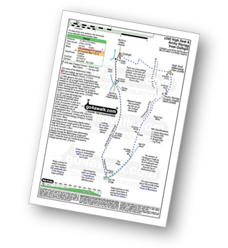
Route Summary:
Outhgill - Thrang Beck - The Lady Anne's Way - Hell Gill Bridge - Hell Gill Beck - Hangingstone Scar - Black Fell Moss - Archy Styrigg (Gregory Chapel) - High Seat (Mallerstang) - Mallerstang Edge - Othgill.
|
Vital Statistics:
| Length: | 13.75 miles (22 km) |
| Ascent: | 2,507ft (764m) |
| Time: | 7½ hrs |
| Grade: |  |
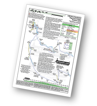
Route Summary:
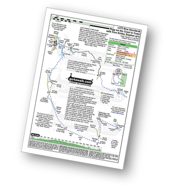
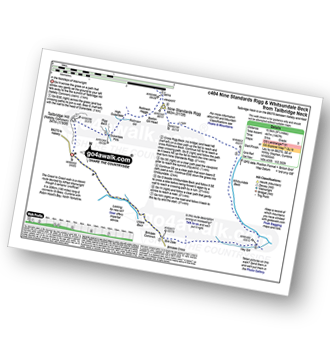
Kirkby Stephen - Market Square - Frank's Bridge - The River Eden - Ladthwaite Beck - Ewbank Scar - Birkett Hill - Ladthwaite Farm - Faraday Gill - Nine Standards Rigg - White Mossy Hill - Coldbergh Scar - Dukerdale Head - Dukerdale Pots - Rigg Beck - Nateby Common (Tailbridge Hill) - Green Hill - Stank Hill - Great Bell (Long Crag) - Kitchen Gill - B6259 - Nateby - The River Eden - Kirkby Stephen
|
Vital Statistics:
| Length: | 12.5 miles (20 km) |
| Ascent: | 2,127ft (648m) |
| Time: | 6.75hrs |
| Grade: | |
Route Summary:
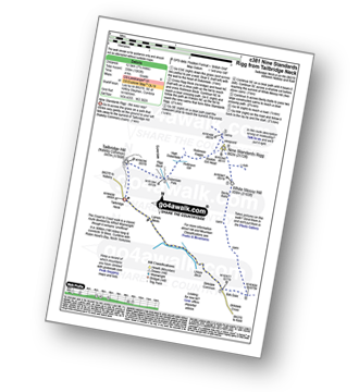
Kirkby Stephen - Market Square - Frank's Bridge - Hartley - Fell House - Hartley Fell - Faraday Gill - Nine Standards Rigg - White Mossy Hill - Coldbergh Scar - Dukerdale Head - Dukerdale Pots - Rigg Beck - Nateby Common (Tailbridge Hill) - B6270 - Tailbridge Neck - Green Hill - Stank Hill - Great Bell (long Crag) - Kitchen Gill - B6259 - Nateby - The River Eden - Kirkby Stephen
|
Vital Statistics:
| Length: | 7.75 miles (12 km) |
| Ascent: | 1,083ft (330m) |
| Time: | 4 hrs |
| Grade: |  |
Route Summary:
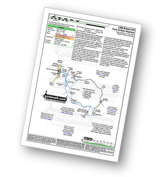
B6270 - Tailbridge Neck - Nateby Common (Tailbridge Hill) - Dukerdale Pots - Tollinson Gill - Rollinson Haggs - Boston Gill Head - Nine Standards Rigg - White Mossy Hill - Birk Dale - Birkdale Cross - Birkdale Common - Uldale Beck - Lamps Moss - Tailbridge Neck.
|
Vital Statistics:
| Length: | 11.25 miles (18 km) |
| Ascent: | 1,601ft (488m) |
| Time: | 5½ hrs |
| Grade: | |
Route Summary:
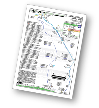
Rawthey Bridge - River Rawthey - Holmes Moss - Rawthey Gill - Rawthey Gill Quarry - Rawthey Gill Foot - Baugh Fell (Tarn Rigg Hill) - Broken Gill - Tarn Rigg Hill - Knoutberry Haw - West Baugh Fell Tarn - Raven Thorn - Rawthey Bridge
|
Vital Statistics:
| Length: | 5.5 miles (9 km) |
| Ascent: | 1,182ft (360m) |
| Time: | 3.25hrs |
| Grade: | |
Route Summary:
Kirkby Stephen - Market Square - Frank's Bridge - The River Eden - Ladthwaite Beck - Ewbank Scar - Birkett Hill - Ladthwaite Farm - Fell House - Hartley - Kirkby Stephen
|
Vital Statistics:
| Length: | 9.75 miles (15.5 km) |
| Ascent: | 1,467ft (447m) |
| Time: | 5 hrs |
| Grade: | |
Route Summary:
B6270 - Tailbridge Neck - Nateby Common (Tailbridge Hill) - Dukerdale Pots - Tollinson Gill - Rollinson Haggs - Boston Gill Head - Nine Standards Rigg - Whitsundale Beck - Ney Gill - Birk Dale - Birkdale Cross - Birkdale Common - Uldale Beck - Lamps Moss - Tailbridge Ne.
|
Vital Statistics:
| Length: | 11 miles (17.5 km) |
| Ascent: | 2,681ft (817m) |
| Time: | 6.75hrs |
| Grade: | |
Route Summary:
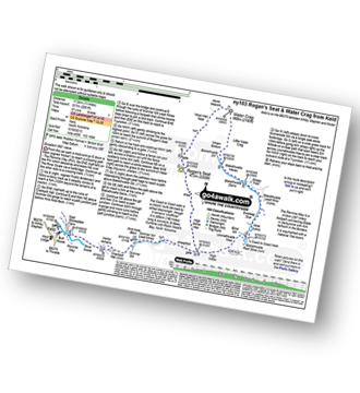
Keld - The Pennine Way - The Herriot Way - The River Swale - Swaledale - Wainwright's Coast to Coast Walk - Kisdon Force - Crackpot Hall - Swinner Gill - Hind Hole Beck - Swinner Gill Lead Mines - East Grain - High Stone Man - Rogan's Seat - Moor Hen Nest - Water Crag (Arkengarthdale) - Blakethwaite Gill - Blakethwaite Meres - Blakethwaite Dams - Gunnerside Gill - Eweleap Scar - Bling Gill - Lownathwaite Mea - High Whim - Swinner Gill - Kisdon Force - Crackpot Hall - Keld
|
Vital Statistics:
| Length: | 8.5 miles (13.5 km) |
| Ascent: | 1,030ft (314m) |
| Time: | 4 hrs |
| Grade: | |
Route Summary:
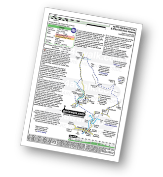
Hawes - The Pennine Way - The Herriot Way - Haylands Bridge - The River Ure - Hardraw - Hardraw Force - Shaw Gill Wood - Simonstone Hotel - High Shaw - Shivery Gill - Pike Hill - Abbotside Common - Low Clint - High Pasture Gate - Shutt Lane - Sedbusk - Hawes
|
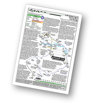
Vital Statistics:
| Length: | 7.75 miles (12.5 km) |
| Ascent: | 1,214ft (370m) |
| Time: | 4.25hrs |
| Grade: | |
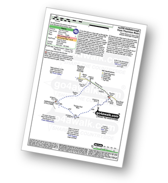
Route Summary:
Askrigg - Askrigg Bottoms - The River Ure - Wensleysdale - Worton Bridge - Worton - Cubeck - Carpley Green Road - Worton Pasture - Carpley Green Farm - Addlebrough - Swallow Hole - Worton Scar - Worton - Wensleydale - Askrigg Bottoms - Askrigg
|
Vital Statistics:
| Length: | 5 miles (8 km) |
| Ascent: | 502ft (153m) |
| Time: | 2½ hrs |
| Grade: |  |
Route Summary:
Askrigg - Askrigg Bottoms - The River Ure - Wensleysdale - Worton Bridge - Worton - Worton Scar - Thornton Scar - Thornton Rust - River Ure - Wensleydale - Nappa Mill Farm - Askrigg
|
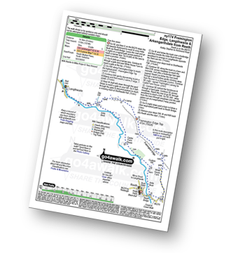
Vital Statistics:
| Length: | 8.75 miles (14 km) |
| Ascent: | 1,870ft (570m) |
| Time: | 5 hrs |
| Grade: | |
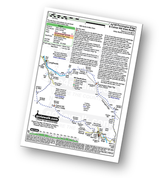
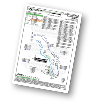
Route Summary:
Reeth - Arkle Beck - High Fremington - White House Farm - Fremington Edge - Fremington Edge Top - Fell End Lead Mine - Storthwaite Hall - Arkengarthdale - Langthwaite - Arken Town - Calver Hill - Riddings Farm - Skelgate Lane - Wainwright's Coast to Coast Walk - The Herriot Way - Reeth
|
Vital Statistics:
| Length: | 3.75 miles (6 km) |
| Ascent: | 295ft (90m) |
| Time: | 1.75hrs |
| Grade: |  |
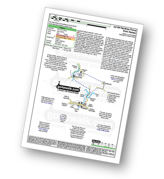
Route Summary:
Hawes - The Pennine Way - The Herriot Way - Haylands Bridge - The River Ure - Hardraw - Hardraw Force - West House - Simonstone Hotel - Sedbusk - Hawes
|
Vital Statistics:
| Length: | 11.25 miles (18 km) |
| Ascent: | 2,091ft (637m) |
| Time: | 6.25hrs |
| Grade: | |
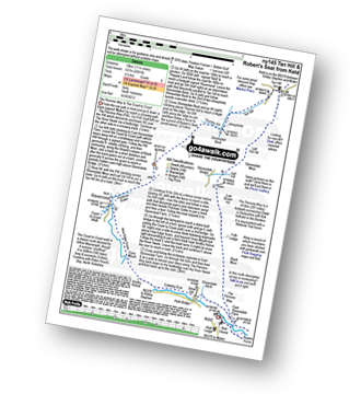
Route Summary:
Keld - The Pennine Way - The Herriot Way - Kisdon Force - Black Moor - Stonesdale Moor - The Tan Hill Inn - Tan Gill - Stonesdale Beck - Thomas Gill - Robert's Seat - Pryclose Gutter - Ravenseat - Wainwright's Coast to Coast Walk - Whitsundale Beck - How Edge Scars - Oven Mouth - Cotterby Scar - East Stonesdale Farm - The River Swale - Keld
|
Vital Statistics:
| Length: | 13.75 miles (22 km) |
| Ascent: | 2,330ft (710m) |
| Time: | 7.25hrs |
| Grade: | |
Route Summary:
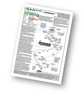
Hawes - The Pennine Way - The Herriot Way - Haylands Bridge - The River Ure - Hardraw - Hardraw Force - Hearne Coal Road - Hollin Hill - Bluebell Hill - Blea Pot Plain - Hearn Top - Bleak Haw - Hearne Head - Great Shunner Fell - Little Shunner Fell - Pickersett Mea - Fossdale Moss - Grimy Gutter - Lovely Seat - Coal Gill Hags - Abbotside Common - High Clint - High Pasture Gate - Shutt Lane - Sedbusk - Hawes
|
Vital Statistics:
| Length: | 12.75 miles (20.5 km) |
| Ascent: | 1,935ft (590m) |
| Time: | 6½ hrs |
| Grade: | |
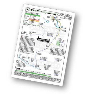
Route Summary:
Reeth - River Swale - Harkerside Place Farm - Harker Mires - The Herriot Way - Low Harker Hill - High Harker Hill - Blue Hill - Beldow Hill - Green Hill Ends - Whitaside Moor - ashpot Gutters - Apedale Road (Track) Apedale - Dent's House - Greets Hill - How Hill - Grinton Lodge - The Herriot Way - Grinton - Arkle Beck - Reeth
|
Vital Statistics:
| Length: | 9.75 miles (15.5 km) |
| Ascent: | 1,388ft (423m) |
| Time: | 5 hrs |
| Grade: | |
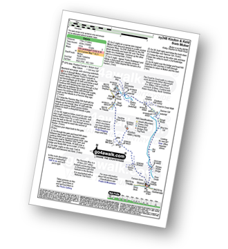
Route Summary:
Askrigg - Askrigg Bottoms - The River Ure - Wensleysdale - Worton Bridge - Worton - Cubeck - Carpley Green Road - Worton Pasture - Carpley Green Farm - Addlebrough - Thornton Rust Moor - Thornton Rust - River Ure - Wensleydale - Nappa Mill Farm - Askrigg
|
Vital Statistics:
| Length: | 9 miles (14.5 km) |
| Ascent: | 1,674ft (510m) |
| Time: | 5 hrs |
| Grade: | |
Route Summary:
Reeth - Wainwright's Coast to Coast Walk - Arkle Beck - High Fremington - White House Farm - Fremington Edge - Fremington Edge Top - Fell End Lead Mine - Storthwaite Hall - Arkengarthdale - Langthwaite - Castle Farm House - Cuckoo Hill - The Herriot Way - Reeth
|
Vital Statistics:
| Length: | 4.5 miles (7 km) |
| Ascent: | 870ft (265m) |
| Time: | 2½ hrs |
| Grade: | |
Route Summary:
Thornton Rust - Thornton Rust Moor - Addlebrough - Swallow Hole - Worton Scar - Thornton Scar - Thornton Rust
|
Vital Statistics:
| Length: | 7 miles (11 km) |
| Ascent: | 1,674ft (411m) |
| Time: | 4 hrs |
| Grade: | |
Route Summary:
Reeth - Wainwright's Coast to Coast Walk - Arkle Beck - High Fremington - White House Farm - Fremington Edge - Fremington Edge Top - Fell End Lead Mine - Storthwaite Hall - Arkengarthdale - Castle Farm House - Cuckoo Hill - The Herriot Way - Reeth
|
Vital Statistics:
| Length: | 7 miles (11 km) |
| Ascent: | 1,345ft (410m) |
| Time: | 3.75hrs |
| Grade: | |
Route Summary:
Muker - Kisdon - Hooker Mill Scar - Swallow Hole Farm - Keld - The Herriot Way - The Pennine Way - The River Swale - Wainwright's Coast to Coast Walk - Kisdon Force - East Gill Force - Crackpot Hall - Swinner Gill - Arngill Wood - Swaledale - Ramps Holme Bridge - Muker
See this list of walks, routes & maps in:
Grade Order |
Length Order |
Time Order |
Walk Number or Start Location Order
NB. To reverse (toggle) this order, click Grade Order again
To contribute to go4awalk.com or to contact us about anything at all - see Talk To Us. For help see Help.
go4awalk.com and go4awalk.co.uk are registered trademarks of TMDH Limited.
Copyright © 2000-2024 TMDH Limited. All rights reserved.
Copyright | Terms & Conditions | Privacy Statement
A - Z
Walks
Home
Log On/Accounts
Photo Gallery
Walk Ideas and Collections
Fell Facts
Places to Stay
Hill Skills
Walking Questions and Answers
Your Stories
News
Competitions
Product Reviews/Gear Tests
Walking Gear Guides
Peaks and Mountains
Peak Bagging
Find New Walking Friends
Camping
GPS Waypoints for Walking
Walk Search
Talk to us
go4awalk.com Help
Free example walks
Newsletter


