46 easy-to-follow circular walk route maps of all grades in The Western Fells area of The Lake District
Forty-six easy-to-follow, hand-crafted walks including routes from Buttermere, Ennerdale Water, Honister, Loweswater, Seathwaite & Seatoller that climb Great Gable (the highest point), Haystacks, High Style, Kirk Fell & Pillar amongst others. More details about each walk can be found below the map.
The Western Fells area of The Lake District National Park is enclosed by:
- The edge of The Lake District National Park from Egremont to Cockermouth to the North West
- Lorton Vale, Crummock Water, Buttermere and Honister Pass to the North East
- Sty Head Pass and Wasdale to the South East
- An imaginary line from the Southern Tip of Wast Water to Egremont to the South West
Tap/mouse over a coloured circle (1-3 easy walks, 4-6 moderate walks, 7-9 hard walks) and click to select.
You can use these checkboxes to show only the grades of walk you are interested in:-
Scroll down the list of walks below & click on each walk title (in blue) to locate it on the map above.
See this list of walks, routes & maps in:
Grade Order |
Length Order |
Time Order |
Walk Number or Start Location Order
NB. To reverse (toggle) this order, click Start Order again
   |
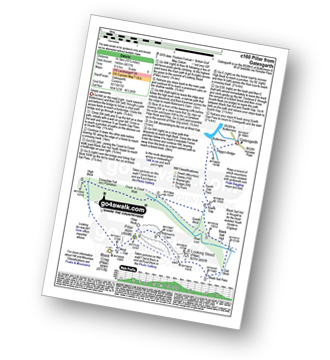
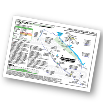
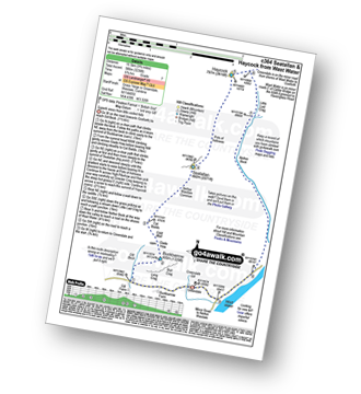
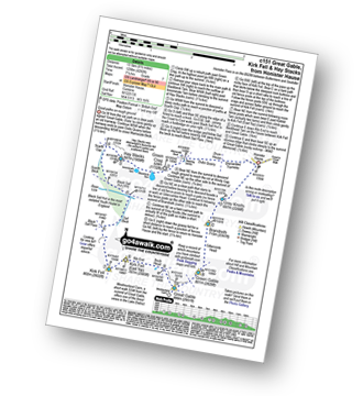
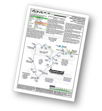
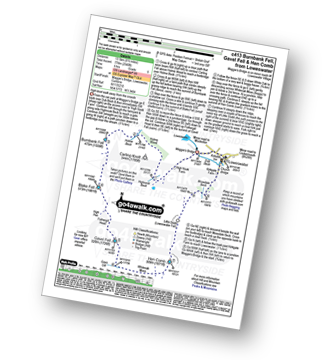
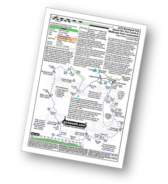
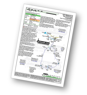
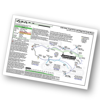
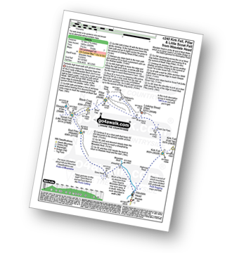
Vital Statistics:
| Length: | 5.25 miles (8.5 km) |
| Ascent: | 2,301ft (701m) |
| Time: | 4½ hrs |
| Grade: |  |
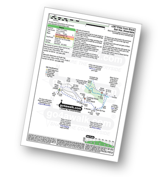
Route Summary:
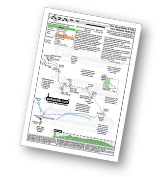
Black Sail Hut (Youth Hostel) - Ennerdale - Black Sail Beck - Black Sail Pass - Looking Stead (Pillar) - Pillar - Black Sail Pass - Black Sail Beck - Black Sail Hut (Youth Hostel) - Ennerdale.
|
Vital Statistics:
| Length: | 11.25 miles (18 km) |
| Ascent: | 3,275ft (998m) |
| Time: | 7½ hrs |
| Grade: |  |
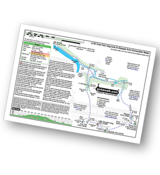
Route Summary:
Bowness Knott Car Park Ennerdale Water - Char Dub - Silver Cove Beck - Woundell Beck - Caw Fell - Little Gowder Crag - Haycock - Great Scoat Fell - Scoat Fell (Little Scoat Fell) - Steeple - Long Crag - Moss Dub - Lingmell Plantation - Bowness Knott Car Park Ennerdale Water.
|
Vital Statistics:
| Length: | 18.75 miles (30 km) |
| Ascent: | 7,309ft (2,408m) |
| Time: | 14.75hrs |
| Grade: |  |
Route Summary:
Bowness Knott Car Park Ennerdale - Low Gillerthwaite Field Centre - High Gillerthwaite Yourth Hostel - Red Pike (Buttermere) - High Stile - High Crag (Buttermere) - Seat (Buttermere) - Scarth Gap - Hay Stacks (Haystacks) - Innominate Tarn - Blackbeck Tarn - Black Beck - Green Crag (Buttermere) - Great Round How - Brandreth - Gillercomb Head - Green Gable - Windy Gap - Great Gable - Westmorland Cairn - Beck Head - Beckhead Tarn - Kirk Fell (East Top) - Kirk Fell - Black Sail Pass - Looking Stead (Pillar) - High Level Route - Robinson's Cairn - Pillar - Wind Gap - Black Crag (Pillar) - High Beck - Low Beck - Ennerdale.
|
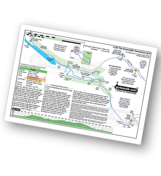
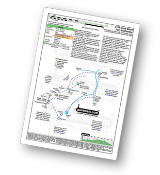
Vital Statistics:
| Length: | 7.25 miles (11.5 km) |
| Ascent: | 683ft (208m) |
| Time: | 3.25hrs |
| Grade: |  |
Route Summary:
Bowness Knott Car Park - Bowness Plantations - River Liza - Ennerdale Water - Coast To Coast Path - Robin Hood's Chair - Anglers' Crag - Ennerdale Weir - River Ehen - Ennerdale Water - Bowness Knott Car Park
|
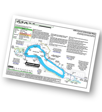
Vital Statistics:
| Length: | 9.75 miles (15.5 km) |
| Ascent: | 2,734ft (833m) |
| Time: | 6.25hrs |
| Grade: |  |
Route Summary:
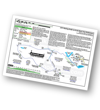
Buttermere - Buttermere Dubbs - Scale Bridge - Scale Force - Scale Beck - Blea Crag - Lingcomb Edge - Ling Comb - Little Dodd (Ennerdale) - Starling Dodd - Great Borne - Floutern Tarn - Black Beck (Mosedale) - Scale Force - Scale Beck (Crummock Water) - Crummock Water - Buttermere
|
Vital Statistics:
| Length: | 4.75 miles (7.5 km) |
| Ascent: | 485ft (148m) |
| Time: | 2 hrs |
| Grade: |  |
Route Summary:
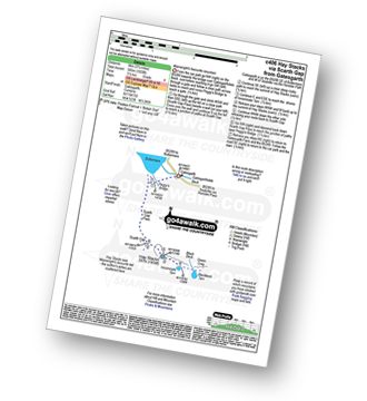
Buttermere - Dalegarth - Hassnesshow Beck - Gatesgarth - Black Beck - Peggy's Bridge - Burtness Wood - Buttermere
|
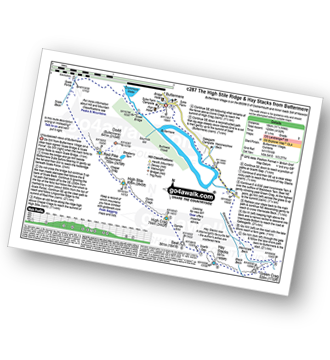
Vital Statistics:
| Length: | 5.80 miles (8.5 km) |
| Ascent: | 2,455ft (748m) |
| Time: | 4½ hrs |
| Grade: | |
Route Summary:
Buttermere - Gatesgarth - Peggy's Bridge - Buttermere - Scarth Gap - Hay Stacks (Haystacks) - Innominate Tarn - Blackbeck Tarn - Black Beck - Green Crag (Buttermere) - Warnscale Beck - Dubs Hut - Dubs Quarry - Fleetwith Pike - Honister Crag (Black Star) - Fleetwith Pike - Fleetwith Edge - Gatesgarth - Buttermere
|
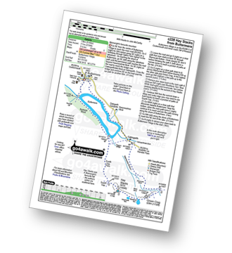
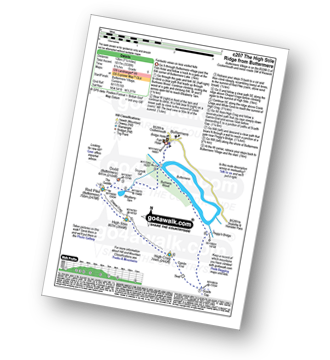
Vital Statistics:
| Length: | 3.25 miles (6 km) |
| Ascent: | 1,920ft (585m) |
| Time: | 3½ hrs |
| Grade: |  |
Route Summary:
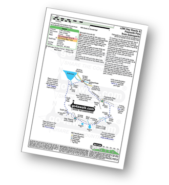
Buttermere - Gatesgarth - Peggy's Bridge - Buttermere - Scarth Gap - Hay Stacks - Innominate Tarn - Hay Stacks (Haystacks) - Scarth Gap - Peggy's Bridge - Gatesgarth - Buttermere
|
Vital Statistics:
| Length: | 10.25 miles (16.5 km) |
| Ascent: | 4,611ft (1,405m) |
| Time: | 8½ hrs |
| Grade: |  |
Route Summary:
Buttermere - Gatesgarth - Peggy's Bridge - Scarth Gap Pass - Scarth Gap - Black Sail Hut (Youth Hostel) - Black Sail Pass - Looking Stead (Pillar). High Level Route - Robinson's Cairn - Pillar - Wind Gap - Black Crag (Pillar) - High Beck - Ennerdale - Scarth Gap Pass - Peggy's Bridge - Gatescarth - Buttermere
|
Vital Statistics:
| Length: | 8.25 miles (13 km) |
| Ascent: | 2,334ft (711m) |
| Time: | 5½ hrs |
| Grade: | |
Route Summary:
Buttermere - Gatesgarth - Warnscale Bottom - Warnscale Beck - Green Crag (Buttermere) - Black Beck - Blackbeck Tarn - Innominate Tarn - Hay Stacks (Haystacks) - Scarth Gap - Burtness Wood - Buttermere
|
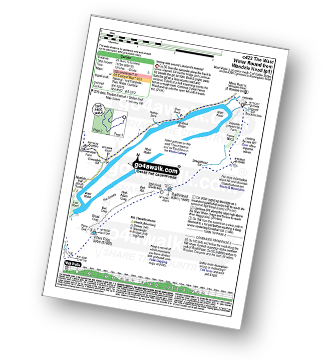
Vital Statistics:
| Length: | 7.5 miles (12 km) |
| Ascent: | 262ft (80m) |
| Time: | 3 hrs |
| Grade: | |
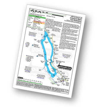
Route Summary:
Buttermere - Great Wood - Wood House - Crummock Water - Hause Point - Rannerdale Bridge - Cinderdale Common - Lanthwaite Green - High Wood - Lanthwaite Wood - River Cocker - Park Beck - Iron Stone - Low Ling Crag - Scale Bridge - Buttermere
|
Vital Statistics:
| Length: | 16 miles (25.5 km) |
| Ascent: | 6,285ft (1,915m) |
| Time: | 12.25hrs |
| Grade: | |
Route Summary:
Buttermere - Scale Force - Scale Beck - Blea Crag - Great Borne - Starling Dodd - Little Dodd (Ennerdale) - Ling Comb - Lingcomb Edge - Red Pike (Buttermere) - Dodd (Buttermere) - Red Pike (Buttermere) - High Stile - High Crag (Buttermere) - Gamlin End - Seat (Buttermere) - Scarth Gap - Hay Stacks (Haystacks) - Innominate Tarn - Blackbeck Tarn - Black Beck - Green Crag (Buttermere) - Warnscale Beck - Dubs Hut - Dubs Quarry - Fleetwith Pike - Honister Crag (Black Star) - Fleetwith Pike - Fleetwith Edge - Gatesgarth - Buttermere
|
Vital Statistics:
| Length: | 8.75 miles (14 km) |
| Ascent: | 3,390ft (1,033m) |
| Time: | 6.25hrs |
| Grade: | |
Route Summary:
Buttermere - Scale Force - Scale Beck - Blea Crag - Lingcomb Edge - Red Pike (Buttermere) - High Stile - High Crag (Buttermere) - Gamlin End - Seat (Buttermere) - Scarth Gap - Burtness Wood - Sourmilk Gill - Buttermere
|
Vital Statistics:
| Length: | 11.25 miles (18 km) |
| Ascent: | 4,132ft (1,259m) |
| Time: | 8.25hrs |
| Grade: | |
Route Summary:
Buttermere - Scale Force - Scale Beck - Blea Crag - Lingcomb Edge - Red Pike (Buttermere) - High Stile - High Crag (Buttermere) - Gamlin End - Seat (Buttermere) - Scarth Gap - Hay Stacks (Haystacks) - Innominate Tarn - Blackbeck Tarn - Black Beck - Green Crag (Buttermere) - Warnscale Beck - Warnscale Bottom - Gatesgarth - Buttermere
|
Vital Statistics:
| Length: | 7.5 miles (12 km) |
| Ascent: | 3,338ft (1,017m) |
| Time: | 6.25hrs |
| Grade: | |
Route Summary:
Buttermere - Sourmilk Gill - Bleaberry Tarn - Dodd (Buttermere) - The Saddle - Red Pike (Buttermere) - High Stile - High Crag (Buttermere) - Gamlin End - Seat (Buttermere) - Scarth Gap - Peggy's Bridge - Burtness Wood - Buttermere
|
Vital Statistics:
| Length: | 9.75 miles (15.5 km) |
| Ascent: | 3,157ft (962m) |
| Time: | 6½ hrs |
| Grade: | |
Route Summary:
Buttermere - Sourmilk Gill - Bleaberry Tarn - Dodd (Buttermere) - The Saddle - Red Pike (Buttermere) - Ling Comb - Little Dodd (Ennerdale) - Starling Dodd - Great Borne - Floutern Tarn - Black Beck (Mosedale) - Blea Crag - Scale Force - Scale Beck (Crummock Water) - Crummock Water - Buttermere Dubs - Buttermere
|
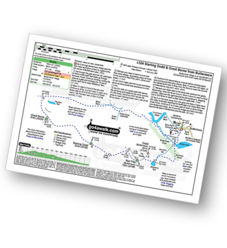
Vital Statistics:
| Length: | 11.75 miles (19 km) |
| Ascent: | 2,970ft (905m) |
| Time: | 7½ hrs |
| Grade: | |
Route Summary:
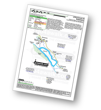
Ennerdale Weir - Ennerdale Water - Silver Cove Beck - Woundell Beck - Caw Fell - Silver Cove - Iron Crag - Crag Fell - Grike - Ennerdale Weir
|
Vital Statistics:
| Length: | 15.25 miles (24.5 km) |
| Ascent: | 4,125ft (1,257m) |
| Time: | 9.75hrs |
| Grade: | |
Route Summary:
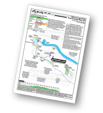
Ennerdale Weir - Ennerdale Water - Silver Cove Beck - Woundell Beck - Little Gowder Crag - Haycock - Caw Fell - Silver Cove - Iron Crag - Whoap - Lank Rigg - Crag Fell - Grike - Ennerdale Weir
|
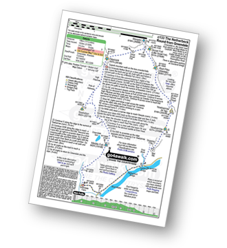
Vital Statistics:
| Length: | 8.75 miles (14 km) |
| Ascent: | 1,854ft (565m) |
| Time: | 5 hrs |
| Grade: | |
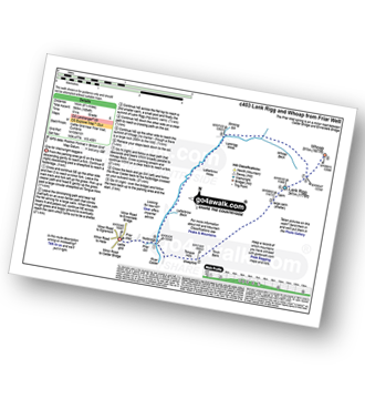
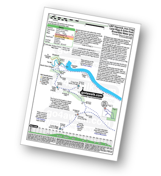
Route Summary:
Friar Well - Friar Gill - River Calder - Tongue How - Town Bank - Lank Rigg - Whoap - Whoap Beck - Stinking Gill - Lankrigg Moss - Latterbrow Moss - Latterbrow Beck - Friar Well
|
Vital Statistics:
| Length: | 11 miles (17.5 km) |
| Ascent: | 1,418ft (432m) |
| Time: | 5½ hrs |
| Grade: | |
Route Summary:
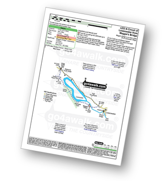
Gosforth - Rowend Bridge - River Bleng - Bleng Bridge - Hall Bolton - Bolton Head - Low Thistleton Farm - High Thistleton Farm - Guards Head Farm - Hollow Moor - Brown Edge - Blengdale Forest - River Bleng - Scalderskew Beck - Ponsonby Fell - Scargreen Farm - Gidd Hall Farm - Ponsonby Old Hall - Middle Boonwood - Gosforth
|
Vital Statistics:
| Length: | 9.75 miles (15.5 km) |
| Ascent: | 3,236ft (986m) |
| Time: | 6.75hrs |
| Grade: | |
Route Summary:
Greendale Farm - Gill Farm - Buckbarrow - Seatallan - Pots of Ashness - Gowder Crag - Haycock - Little Lad Crag - Nether Beck - Wast Water - Wasdale - Greendale Farm
|
Vital Statistics:
| Length: | 6 miles (9.5 km) |
| Ascent: | 2,504ft (763m) |
| Time: | 4.75hrs |
| Grade: | |
Route Summary:
Greendale Farm - Gill Farm - Gill Beck - Buckbarrow - Glade How - Cat Bields - Nether Wasdale Common - Seatallan - Pots of Ashness - Windscale Hows - Middle Fell (Wasdale) - Greendale Gill - Greendale Farm
|
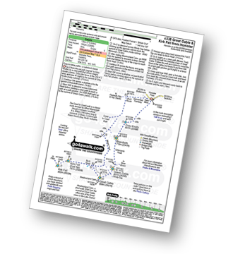
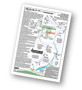
Vital Statistics:
| Length: | 11.25 miles (18 km) |
| Ascent: | 5,100ft (1,554m) |
| Time: | 9.25hrs |
| Grade: | |
Route Summary:
Greendale Farm - Middle Fell (Wasdale) - Seatallan - Pots of Ashness - Gowder Crag - Haycock - Great Scoat Fell - Steeple - Scoat Fell (Little Scoat Fell) - Red Pike (Wasdale) - Dore Head - Yewbarrow (North Top) - Yewbarrow - Bell Rib - Dropping Crag - Overbeck Bridge - Wast Water - Greendale Farm
|
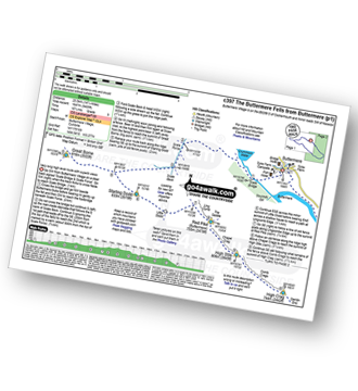
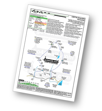
Vital Statistics:
| Length: | 6.25 miles (10 km) |
| Ascent: | 2,756ft (840m) |
| Time: | 5.25hrs |
| Grade: | |
Route Summary:
Honister Pass - Honister Hause - Bell Crags - Hopper Quarry - Honister Quarries - Honister Crag (Black Star) - Burnt Scarth - Fleetwith Pike - Dubs Hut - Dubs Quarry - Warnscale Beck - Green Crag (Buttermere) - Blackbeck Tarn - Innominate Tarn - Hay Stacks (Haystacks) - Innominate Tarn - Loft Beck - Coast to Coast Walk - Brandreth - Grey Knotts - Honister Hause.
|
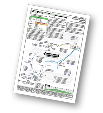
Vital Statistics:
| Length: | 8.5 miles (13.5 km) |
| Ascent: | 4,260ft (1,298m) |
| Time: | 7.25hrs |
| Grade: | |
Route Summary:
Honister Pass - Honister Hause - Green Crag (Buttermere) - Black Beck - Blackbeck Tarn - Innominate Tarn - Hay Stacks (Haystacks) - Scarth Gap - Ennerdale - River Liza - Black Sail Hut (Youth Hostel) - Black Sail Path - Kirk Fell - Kirk Fell (East Top) - Beckhead Tarn - Beck Head - Great Gable - Westmorland Cairn - Windy Gap - Green Gable - Gillercomb Head - Brandreth - Grey Knotts - Honister Hause.
|
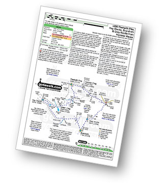
Vital Statistics:
| Length: | 9 miles (14.5 km) |
| Ascent: | 3,965ft (1,208m) |
| Time: | 7½ hrs |
| Grade: | |
Route Summary:
Honister Pass - Honister Hause - Grey Knotts - Brandreth - Blackmoor Pols - Base Brown - Mitchell Cove - Green Gable - Windy Gap - Great Gable - Westmorland Cairn - Beck Head - Beckhead Tarn - Kirk Fell (East Top) - Kirk Fell - Moses' Trod - Wainwright's Coast to Coast Walk - Honister Pass
|
Vital Statistics:
| Length: | 7.5 miles (12 km) |
| Ascent: | 3,289ft (1,002m) |
| Time: | 6 hrs |
| Grade: | |
Route Summary:
Honister Pass - Honister Hause - Grey Knotts - Brandreth - Green Gable - Windy Gap - Great Gable - Westmorland Cairn - Beck Head - Beckhead Tarn - Kirk Fell (East Top) - Kirk Fell - Moses' Trod - Wainwright's Coast to Coast Walk - Honister Pass
|
Vital Statistics:
| Length: | 5.75 miles (9 km) |
| Ascent: | 2,340ft (731m) |
| Time: | 4½ hrs |
| Grade: | |
Route Summary:
Honister Pass - Honister Hause - Grey Knotts - Brandreth - Green Gable - Windy Gap - Great Gable - Westmorland Cairn - Beck Head - Beckhead Tarn - Moses' Trod - Wainwright's Coast to Coast Walk - Honister Pass
|
Vital Statistics:
| Length: | 8.75 miles (14 km) |
| Ascent: | 1,884ft (574m) |
| Time: | 5 hrs |
| Grade: | |
Route Summary:
Lanthwaite - Acorn Cottage - Crummockwater Cottages and Foulsyke - Pottergill - Raven Crag (Low Fell) - Low Fell - Low Fell (South Top) - Fellbarrow - Mosser Fell - Wilkes How - Waterend Youth Hostel - Hudson Place Farm - Holme Wood - Watergate Farm - Maggie's Bridge (Loweswater) - Loweswater - Lanthwaite
|
Vital Statistics:
| Length: | 6.5 miles (10.5 km) |
| Ascent: | 1,877ft (572m) |
| Time: | 4.25hrs |
| Grade: | |

Route Summary:
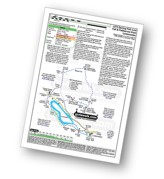
Lanthwaite - Scale Hill - Scalehill Bridge - Muncaster House - Loweswater - Low Park - Mellbreak (North Top) - Mellbreak - Black Beck (Mosedale) - Scale Knott - Scale Beck - High Ling Crag - Low Ling Crag - Crummock Water - Lanthwaite
|
Vital Statistics:
| Length: | 7 miles (11 km) |
| Ascent: | 1,726ft (526m) |
| Time: | 4.25hrs |
| Grade: | |
Route Summary:
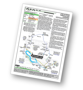
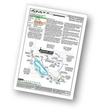
Maggie's Bridge (Loweswater) - Acorn Cottage - Crummockwater Cottages and Foulsyke - Pottergill - Raven Crag (Low Fell) - Low Fell - Low Fell (South Top) - Crabtree Beck - Darling Fell - Loweswater - Waterend Youth Hostel - Hudson Place Farm - Holme Wood - Watergate Farm - Maggie's Bridge (Loweswater)
|
Vital Statistics:
| Length: | 4.25 miles (6.5 km) |
| Ascent: | 98ft (30m) |
| Time: | 1½ hrs |
| Grade: |  |
Route Summary:
Maggie's Bridge (Loweswater) - High Thrushbank - Loweswater - Waterend Youth Hostel - Hudson Place Farm - Holme Wood - Watergate Farm - Maggie's Bridge (Loweswater)
|
Vital Statistics:
| Length: | 7.75 miles (12.5 km) |
| Ascent: | 1,923ft (586m) |
| Time: | 4.75hrs |
| Grade: | |
Route Summary:
Maggie's Bridge (Loweswater) - Loweswater - Darling Fell - Crabtree Beck - Low Fell (South Top) - Low Fell - Fellbarrow - Mosser Fell - Wilkes How - Waterend Youth Hostel - Hudson Place Farm - Holme Wood - Watergate Farm - Maggie's Bridge (Loweswater)
|
Vital Statistics:
| Length: | 6.5 miles (10.5 km) |
| Ascent: | 2,025ft (617m) |
| Time: | 4½ hrs |
| Grade: | |
Route Summary:
Maggie's Bridge (Loweswater) - Loweswater - High Nook Farm - Highnook Beck - Holme Wood - Burnbank Fell - Sharp Knott - Blake Fell - Fothergill Head - Gavel Fell - Black Crag (Gavel Fell) - Highnook Beck - Maggie's Bridge (Loweswater)
|
Vital Statistics:
| Length: | 8.5 miles (13.5 km) |
| Ascent: | 2,540ft (774m) |
| Time: | 6 hrs |
| Grade: | |
Route Summary:
Maggie's Bridge (Loweswater) - Loweswater - High Nook Farm - Highnook Beck - Holme Wood - Holme Beck - Burnbank Fell - Sharp Knott - Blake Fell - Fothergill Head - Gavel Fell - Grain Gill - Whiteoak Moss - Hen Comb - Little Dodd (Loweswater Fell) - Mosedale (Loweswater) - Mosedale Beck (Loweswater) - Loweswater Village - Maggie's Bridge (Loweswater)
|
Vital Statistics:
| Length: | 9.5 miles (15 km) |
| Ascent: | 3,666ft (1,117m) |
| Time: | 7.25hrs |
| Grade: | |
Route Summary:
Maggie's Bridge (Loweswater) - Loweswater - High Nook Farm - Highnook Beck - Holme Wood - Holme Beck - Burnbank Fell - Sharp Knott - Blake Fell - Fothergill Head - Gavel Fell - Grain Gill - Whiteoak Moss - Hen Comb - Thrang Crags - Mosedale (Loweswater) - Mosedale Beck (Loweswater) - Mellbreak - Mellbreak (North Top) - White Crag - Loweswater Village - Maggie's Bridge (Loweswater)
|
Vital Statistics:
| Length: | 6.25 miles (10 km) |
| Ascent: | 6ft (770m) |
| Time: | 5 hrs |
| Grade: | |
Route Summary:
Maggie's Bridge (Loweswater) - Loweswater - Kirkgate Farm - Raven Crag - White Crag - Mellbreak (North Top) - Mellbreak - Mosedale Beck (Loweswater) - Thrang Crags - Hen Comb - Little Dodd (Loweswater Fell) - Mosedale Beck (Loweswater) - Kirkgate Farm - Loweswater - Maggie's Bridge (Loweswater)
|
Vital Statistics:
| Length: | 7.75 miles (12.5 km) |
| Ascent: | 2,028ft (618m) |
| Time: | 5½ hrs |
| Grade: | |
Route Summary:
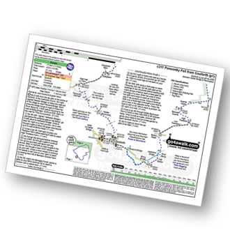
Scaly Moss - Blackely Moss - Heckbarley Wood - Red Moss - Grike - Crag Fell - Black Pots - Whoap - Lank Rigg - Whoap Beck - Lankrigg Moss - Stinking Gill - Blackeley Raise - Whorl Gill - Scaly Moss
|
Vital Statistics:
| Length: | 6 miles (9.5 km) |
| Ascent: | 2,845ft (867m) |
| Time: | 5 hrs |
| Grade: | |
Route Summary:
Seathwaite - Stockley Bridge - Styhead Tarn - Sty Head - Great Gable - Westmorland Cairn - Windy Gap - Green Gable - Mitchell Cove - Blackmoor Pols - Base Brown - Gillercomb - Sour Milk Gill (Borrowdale) - Seathwaite
|
Vital Statistics:
| Length: | 8.25 miles (13 km) |
| Ascent: | 3,016ft (919m) |
| Time: | 6 hrs |
| Grade: | |
Route Summary:
Seatoller (Borrowdale) - Seathwaite - Sourmilk Gill (Seathwaite) - Gillercomb - Blackmoor Pols - Mitchell Cove - Green Gable - Windy Gap - Great Gable - Westmorland Cairn - Beck Head - Beckhead Tarn - Moses' Trod - Honister Pass - Honister Hause - Wainwright's Coast to Coast Walk - Seatoller (Borrowdale)
|
Vital Statistics:
| Length: | 15.25 miles (24.5 km) |
| Ascent: | 4,841ft (1,475m) |
| Time: | 10½ hrs |
| Grade: | |
Route Summary:
Wasdale Head - (National Trust Campsite) - Wast Water - Lingmell Gill - Illgill Head - Whin Rigg - Greathall Gill - Low Wood - Lund Bridge - Woodhow Farm - Woodhow Tarn - Scale Farm - Tosh Tarn - Gill Farm - Gill Beck - Buckbarrow - Cold Well - Nether Wasdale Common - Seatallan - Windscale Hows - Middle Fell (Wasdale) - Greendale Farm - Nether Beck - Overbeck Bridge - Wasdale Head - Wast Water.
|
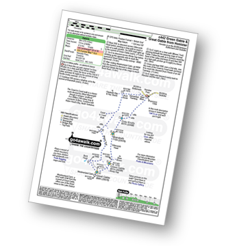
Vital Statistics:
| Length: | 7.75 miles (12.5 km) |
| Ascent: | 4,808ft (1,465m) |
| Time: | 7.75hrs |
| Grade: | |
Route Summary:
Wasdale Head - Kirk Fell - Kirk Fell (East Top) - Black Sail Pass - Looking Stead (Pillar) - High Level Route - Robinson's Cairn - Pillar - Wind Gap - Black Crag (Pillar) - Scoat Fell (Little Scoat Fell) - Steeple - Red Pike (Wasdale) - Dore Head - Mosedale Beck - Wasdale Head - Wast Water.
|
Vital Statistics:
| Length: | 11 miles (17 km) |
| Ascent: | 4,001ft (1,219m) |
| Time: | 8 hrs |
| Grade: | |
Route Summary:
Wasdale Head - Mosedale Beck - Black Sail Pass - High Level Route - Robinson's Cairn - Pillar - Wind Gap - Black Crag (Pillar) - Scoat Fell (Little Scoat Fell) - Red Pike (Wasdale) - Dore Head - Over Beck - Wasdale Head - Wast Water.
|
Vital Statistics:
| Length: | 11 miles (17.5 km) |
| Ascent: | 4,782ft (1,457m) |
| Time: | 8.75hrs |
| Grade: | |
Route Summary:
Wasdale Head - Mosedale Beck - Black Sail Pass - Looking Stead (Pillar) - High Level Route - Robinson's Cairn - Pillar - Wind Gap - Black Crag (Pillar) - Scoat Fell (Little Scoat Fell) - Steeple - Red Pike (Wasdale) - Dore Head - Yewbarrow (North Top) - Yewbarrow - Dropping Crag - Bell Rib - Over Beck - Wasdale Head - Wast Water.
|
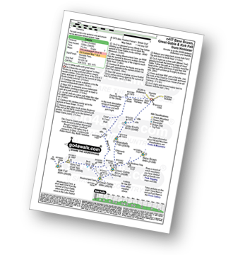
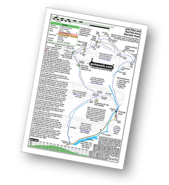
Vital Statistics:
| Length: | 5.25 miles (8.5 km) |
| Ascent: | 2,123ft (647m) |
| Time: | 4 hrs |
| Grade: | |
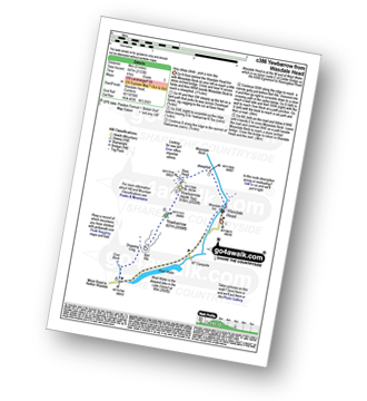
Route Summary:
Wasdale Head - Mosedale Beck - Dore Head - Yewbarrow (North Top) - Yewbarrow - Bell Rib - Dropping Crag - Over Beck - Overbeck Bridge - Wasdale Head - Wast Water.
|
Vital Statistics:
| Length: | 11.25 miles (18 km) |
| Ascent: | 5,819ft (1,773m) |
| Time: | 10 hrs |
| Grade: | |
Route Summary:
Wasdale Head - Moses' Trod - Lingmell Beck - Gable Beck Bridge - Sty Head - Great Gable - Westmorland Cairn - Beck Head - Beckhead Tarn - Kirk Fell (East Top) - Kirk Fell - Black Sail Pass - Looking Stead (Pillar) - High Level Route - Robinson's Cairn - Pillar - Wind Gap - Black Crag (Pillar) - Scoat Fell (Little Scoat Fell) - Steeple - Red Pike (Wasdale) - Dore Head - Mosedale Beck - Wasdale Head - Wast Water.
See this list of walks, routes & maps in:
Grade Order |
Length Order |
Time Order |
Walk Number or Start Location Order
NB. To reverse (toggle) this order, click Start Order again

To contribute to go4awalk.com or to contact us about anything at all - see Talk To Us. For help see Help.
go4awalk.com and go4awalk.co.uk are registered trademarks of TMDH Limited.
Copyright © 2000-2024 TMDH Limited. All rights reserved.
Copyright | Terms & Conditions | Privacy Statement
A - Z
Walks
Home
Log On/Accounts
Photo Gallery
Walk Ideas and Collections
Fell Facts
Places to Stay
Hill Skills
Walking Questions and Answers
Your Stories
News
Competitions
Product Reviews/Gear Tests
Walking Gear Guides
Peaks and Mountains
Peak Bagging
Find New Walking Friends
Camping
GPS Waypoints for Walking
Walk Search
Talk to us
go4awalk.com Help
Free example walks
Newsletter


