6 easy-to-follow circular walk route maps of all grades in The South Western Marches area of The Lake District
Six easy-to-follow, hand-crafted walks including routes from Allithwaite, Beckside Farm, Broad Oak, Broughton Mills, Brown Howe, Grange-over-Sands, Seathwaite, Duddon Valley, Silecroft & Ulverston that climb Black Combe (the highest point), Whit Fell, Buck Barrow, Yoadcastle, Muncaster Fell & Stainton Pike amongst others. More details about each walk can be found below the map.
The South Western Marches area of The Lake District National Park is the area enclosed by:
- The Irish Sea to the South and West
- An imaginary line from Whitehaven to the Southern Tip of Wast Water and then Seathwaite (Duddon Valley) to the North East
- The River Duddon to the East
Tap/mouse over a coloured circle (1-3 easy walks, 4-6 moderate walks, 7-9 hard walks) and click to select.
You can use these checkboxes to show only the grades of walk you are interested in:-
Scroll down the list of walks below & click on each walk title (in blue) to locate it on the map above.
See this list of walks, routes & maps in:
Grade Order |
Length Order |
Time Order |
Walk Number or Start Location Order
NB. To reverse (toggle) this order, click Grade Order again
   |
Vital Statistics:
| Length: | 8.75 miles (14 km) |
| Ascent: | 2,307ft (703m) |
| Time: | 5½ hrs |
| Grade: |  |
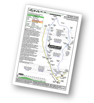
Route Summary:
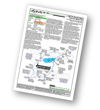
Silecroft - Whicham Church - Kirkbank Farm - Townend Knotts - Black Combe - Blackcombe Screes - William Gill - Hentoe Hill - Butcher's Breast - Littlefell Crags - Tarn Dimples - Whitbeck Mill - Townend Hall - Whitebeck - Throstlerake Crag Fell Brow - Whicham Church - Silecroft
|
Vital Statistics:
| Length: | 5.5 miles (9 km) |
| Ascent: | 1,962ft (598m) |
| Time: | 4 hrs |
| Grade: |  |
Route Summary:
Broughton Mills - River Lickle - Green Bank Farm - The Nursery - Hovel Knott - Dunnerdale Fell (Broughton Mills) - Great Stickle (Dunnerdale Fells) - Stickle Pike (Dunnerdale Fells) - Kiln Bank Cross - Park Head Road - Stainton Ground Quarry - Stephenson Haw - Raven's Crag (Stickle Pike) - The Knott (Dunnerdale Fells) - Broughton Mills
|
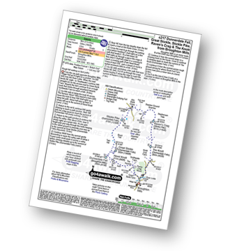
Vital Statistics:
| Length: | 10.25 miles (16.5 km) |
| Ascent: | 2,198ft (670m) |
| Time: | 6 hrs |
| Grade: | |
Route Summary:
Broad Oak - Whitrow Beck - Waberthwaite Fell - Rowantree Falls - Stainton Pike - Whitfell (Whit Fell) - Burn Moor - Buck Barrow - Kinmont Buck Barrow - Whitrow Beck - Broad Oak
|
Vital Statistics:
| Length: | 8.5 miles (13.5 km) |
| Ascent: | 2,645ft (806m) |
| Time: | 5.75hrs |
| Grade: | |
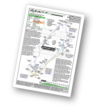
Route Summary:
Silecroft - Whicham Church - Kirkbank Farm - Townend Knotts - Black Combe - Blackcombe Screes - Whitcombe Screes - Stoupdale Head - White Combe - White Hall Knott - Whitecombe Beck - Parsonage Breast - Kirkbank Farm - Whicham Church.
|
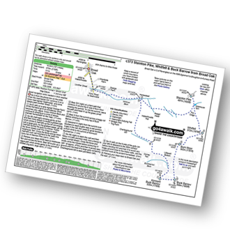
Vital Statistics:
| Length: | 6.25 miles (10 km) |
| Ascent: | 1,611ft (491m) |
| Time: | 4 hrs |
| Grade: | |
Route Summary:
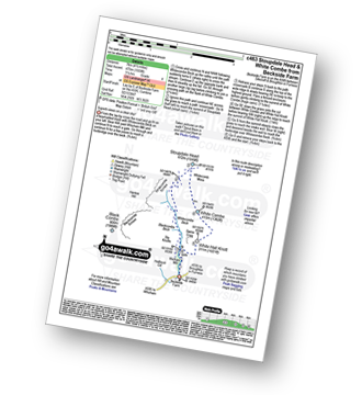
Birker Fell - Tewit Moss - Rough Crag (Birker Fell) - Water Crag (Birker Fell) - Linbeck Gill - Birkby Fell - The Knott (Stainton Fell) - White Pike (Birkby Fell) - Yoadcastle - Woodend Height (Yoadcastle) - Cockly Moss - Rowantree How - Devoke Water - Washfold Point - Seat How (Birker Fell) - Tewit Moss - Birker Fell
|
Vital Statistics:
| Length: | 4.5 miles (7 km) |
| Ascent: | 1,559ft (475m) |
| Time: | 3.25hrs |
| Grade: |  |
Route Summary:
Beckside Farm - Whitecombe Beck - Whitcombe Screes - Stoupdale Head - White Combe - White Hall Knott - Whitecombe Beck - Beckside Farm
See this list of walks, routes & maps in:
Grade Order |
Length Order |
Time Order |
Walk Number or Start Location Order
NB. To reverse (toggle) this order, click Grade Order again

To contribute to go4awalk.com or to contact us about anything at all - see Talk To Us. For help see Help.
go4awalk.com and go4awalk.co.uk are registered trademarks of TMDH Limited.
Copyright © 2000-2024 TMDH Limited. All rights reserved.
Copyright | Terms & Conditions | Privacy Statement
A - Z
Walks
Home
Log On/Accounts
Photo Gallery
Walk Ideas and Collections
Fell Facts
Places to Stay
Hill Skills
Walking Questions and Answers
Your Stories
News
Competitions
Product Reviews/Gear Tests
Walking Gear Guides
Peaks and Mountains
Peak Bagging
Find New Walking Friends
Camping
GPS Waypoints for Walking
Walk Search
Talk to us
go4awalk.com Help
Free example walks
Newsletter


