6 easy-to-follow circular walk route maps of all grades in The South Eastern Marches area of The Lake District
Six easy-to-follow, hand-crafted walks including routes from Ings, Kendal, Mill Side, Underbarrow, Windermere & Winster that climb Brunt Knott (the highest point), Ulgraves, Hugill Fell, Grandsire, Saskills, Scout Scar, Dixon Heights & Cunswick Scart amongst others. More details about each walk can be found below the map.
The South Eastern Marches area of The Lake District National Park is the area enclosed by:
- The A591 from Ambleside towards Kendal to the North
- The new National Park boundary to Morecambe Bay to the East
- Morecambe Bay to the A590 at Greenodd to the South
- The A590 to Newby Bridge and then the shore of Lake Winderemere to Ambleside to the West
Tap/mouse over a coloured circle (1-3 easy walks, 4-6 moderate walks, 7-9 hard walks) and click to select.
You can use these checkboxes to show only the grades of walk you are interested in:-
Scroll down the list of walks below & click on each walk title (in blue) to locate it on the map above.
See this list of walks, routes & maps in:
Grade Order |
Length Order |
Time Order |
Walk Number or Start Location Order
NB. To reverse (toggle) this order, click Grade Order again
   |
Vital Statistics:
| Length: | 7 miles (11 km) |
| Ascent: | 1,218ft (371m) |
| Time: | 3.75hrs |
| Grade: |  |
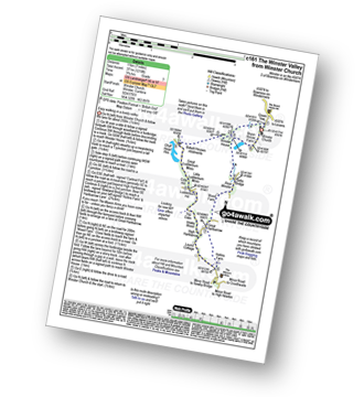
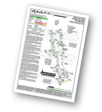
Route Summary:
Winster Church - Winster House - Birkett Houses Allotments - Ghyll Head Reservoir - Great Ludderburn Moss - Little Ludderburn Moss - Ludderburn Hill - The Oaks - Intake Wood - High Hartbaroow - Lound Cottage - Strawberry Bank - Hollins Farm - Great Hartbarrow - Wood Farm - River Winster - Bryan House Farm - Winster Church
|
Vital Statistics:
| Length: | 5.75 miles (9 km) |
| Ascent: | 932ft (284m) |
| Time: | 3 hrs |
| Grade: |  |
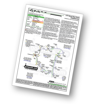
Route Summary:
Underbarrow - Hagg Cottage - Gambleshire Lane - Gambleshire Lane - Cunswick Fell - Scout Scar (Barrowfield) - Hodgeson's Leap - Bradleyfield - Helsington Barrows - Barrowfield Farm - Barrowfield Lot - Copeland Wood - Hollinwood - Cooper Tenement - Rockyfield - Underbarrow
|
Vital Statistics:
| Length: | 6 miles (9.5 km) |
| Ascent: | 531ft (246m) |
| Time: | 2½ hrs |
| Grade: | |
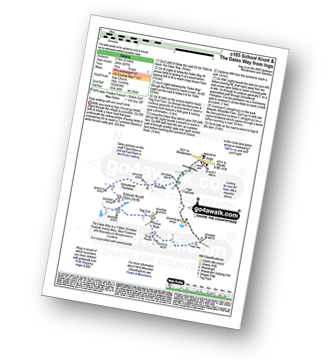
Route Summary:
Ings - High Fairbank - The Dales Way - Crag House Farm - Outrun Nook - Hag End Farm - School Knott - Schoolknott Plantation - Whasdike Farm - Ings
|
Vital Statistics:
| Length: | 7.25 miles (11.5 km) |
| Ascent: | 1,053ft (321m) |
| Time: | 3.75hrs |
| Grade: | |
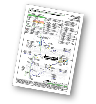
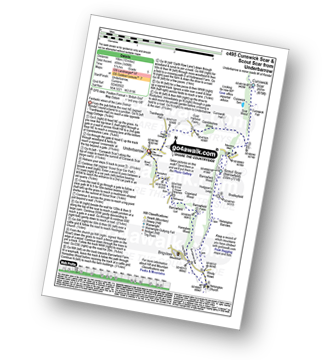
Route Summary:
Kendal - Kendal Fell - Kettlewell Crag - Cunswick Fell - Cunswick Scar - Scout Scar (Barrowfield) - Helsington Barrows - Bradleyfield - Brigsteer Road - Larch How - Kendal
|
Vital Statistics:
| Length: | 6.75 miles (11 km) |
| Ascent: | 1,243ft (379m) |
| Time: | 3.75hrs |
| Grade: | |
Route Summary:
Mill Side - Buckhouse Wood - Farrar's Allotment - Pether Pots. Whitbarrow National Nature Reserve - Lord's Seat (Whitbarrow Scar) - Flodder Allotment - Bell Rake - High Park Wood - Black Yew Scars - Witherslack Hall School - Chapel Head Scar - High Crag Wood - Low Crag Wood - Beck Head - Mill Side
|
Vital Statistics:
| Length: | 10 miles (16 km) |
| Ascent: | 1,496ft (456m) |
| Time: | 5.25hrs |
| Grade: |  |
Route Summary:
Underbarrow - Hagg Cottage - Gambleshire Lane - Gambleshire Lane - Cunswick Fell - Cunswick Scar - Scout Scar (Barrowfield) - Hodgeson's Leap - Bradleyfield - Helsington Barrows - Windy Howe - Helsington Church - Honeybee Wood - Barrowfield Farm - Barrowfield Lot - Copeland Wood - Hollinwood - Cooper Tenement - Rockyfield - Underbarrow
See this list of walks, routes & maps in:
Grade Order |
Length Order |
Time Order |
Walk Number or Start Location Order
NB. To reverse (toggle) this order, click Grade Order again

To contribute to go4awalk.com or to contact us about anything at all - see Talk To Us. For help see Help.
go4awalk.com and go4awalk.co.uk are registered trademarks of TMDH Limited.
Copyright © 2000-2024 TMDH Limited. All rights reserved.
Copyright | Terms & Conditions | Privacy Statement
A - Z
Walks
Home
Log On/Accounts
Photo Gallery
Walk Ideas and Collections
Fell Facts
Places to Stay
Hill Skills
Walking Questions and Answers
Your Stories
News
Competitions
Product Reviews/Gear Tests
Walking Gear Guides
Peaks and Mountains
Peak Bagging
Find New Walking Friends
Camping
GPS Waypoints for Walking
Walk Search
Talk to us
go4awalk.com Help
Free example walks
Newsletter


