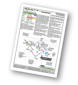
29 easy-to-follow circular walk route maps of all grades in The Far Eastern Fells area of The Lake District
Twenty-nine easy-to-follow, hand-crafted walks including routes from Ambleside, Brothers Water, Christy Bridge, Glenridding, Howtown, Mardale Head, Patterdale, Stockdale & Troutbeck that climb the Angletarn Pikes, High Street (the highest point), Place Fell, Steel Knotts (Pikeawassa), Yoke, Ill Bell, Froswick, Thornthwaite Crag, Stony Cove Pike (Caudale Moor) & Wansfell Pike amongst many others. More details about each walk can be found below the map.
The Far Eastern Fells area of The Lake District National Park is enclosed by:
- Ullswater to the North West
- The Kirkstone Pass and Ambleside to the West
- an imaginary line from Ambleside through Troutbeck, Kentmere and Sadgill to the Eastern tip of Haweswater Reservoir and then North to Pooley Bridge
Tap/mouse over a coloured circle (1-3 easy walks, 4-6 moderate walks, 7-9 hard walks) and click to select.
You can use these checkboxes to show only the grades of walk you are interested in:-
Scroll down the list of walks below & click on each walk title (in blue) to locate it on the map above.
See this list of walks, routes & maps in:
Grade Order |
Length Order |
Time Order |
Walk Number or Start Location Order
NB. To reverse (toggle) this order, click Grade Order again
   |
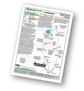
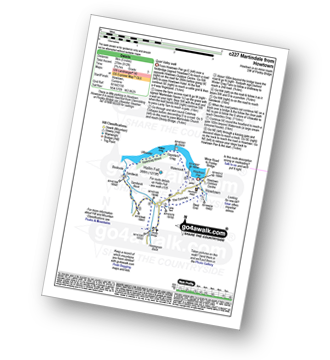
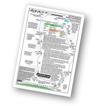
Vital Statistics:
| Length: | 11.25 miles (18 km) |
| Ascent: | 2,736ft (834m) |
| Time: | 6.75hrs |
| Grade: |  |
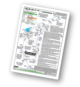
Route Summary:
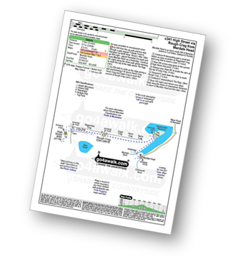
St Peter's Church (Martindale) - Howtown - Swarthbeck Gill - White Knott - Barton Fell - Whinny Crag - Arthur's Pike - Swarth Beck - Bonscale Tower - Bonscale Pike - Loadpot Hill - Wether Hill - Wether Hill (South Top) - Keasgill Head - Steel Knotts (Pikeawassa) - Steel End - St Peter's Church (Martindale) - Howtown
|
Vital Statistics:
| Length: | 14.5 miles (23 km) |
| Ascent: | 3,364ft (1,025m) |
| Time: | 8½ hrs |
| Grade: |  |
Route Summary:
Mardale Head (Haweswater Reservoir) - Small Water - Nan Bield Pass - Mardale Ill Bell - High Street - Straits of Riggindale - The Knott - Rampsgill Head - Kidsty Pike - High Raise (Mardale) - Raven Howe - Red Crag - Keasgill Head - Wether Hill (South Top) - Wether Hill - Bampton Common - Low Kop - Measand Beck - Haweswater Reservoir - Wainwright's Coast to Coast Walk - Bowderthwaite Bridge - The Rigg - Mardale Head
|
Vital Statistics:
| Length: | 4.75 miles (7.5 km) |
| Ascent: | 1,292ft (394m) |
| Time: | 3 hrs |
| Grade: |  |
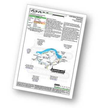
Route Summary:
Howtown - St Peter's Church - Hallin Fell - Geordie's Crag - Hallinhag Wood - Sandwick - Sandwick Beck - Howtown
|
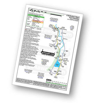
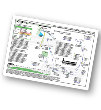
Vital Statistics:
| Length: | 11.25 miles (18 km) |
| Ascent: | 3,843ft (1,171m) |
| Time: | 8 hrs |
| Grade: | |
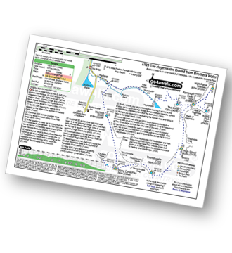
Route Summary:
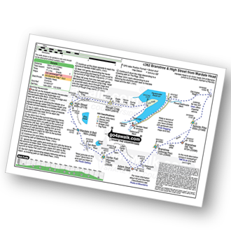
Cow Bridge - Brothers Water - Hartsop - Hartsop Dodd - Caudale Moor - Stony Cove Pike (Caudale Moor) - Caudale Head - Stony Cove Pike - Threshthwaite Mouth - Thornthwaite Crag - High Street - Straits of Riggindale - Rampsgill Head - Kidsty Pike - High Raise (Mardale) - The Knott - Hayeswater Reservoir - Hayeswater Gill - Hartsop - Cow Bridge - Brothers Water.
|
Vital Statistics:
| Length: | 7.5 miles (12 km) |
| Ascent: | 2,283ft (696m) |
| Time: | 5.25hrs |
| Grade: |  |
Route Summary:
Howtown - Steel Knotts (Pikeawassa) - Brownthwaite Crag - Keasgill Head - Wether Hill (South Top) - Wether Hill - Loadpot Hill - Bonscale Pike - Bonscale Tower - Swarthbeck Gill - Howtown
|
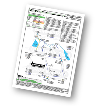
Vital Statistics:
| Length: | 6.5 miles (10.5 km) |
| Ascent: | 643ft (196m) |
| Time: | 3 hrs |
| Grade: |  |
Route Summary:
Patterdale - Noran Bank Farm - Greenbank Farm - Lane Head - Deepdale Bridge - Low Wood - Cow Bridge - Brothers Water - Hartsop Hall - Sykeside - Brothers Water - Hartsop - Eden Beck - Hartsop Fold - Angletarn Beck - Beckstones - Crookabeck - Dubhow - Rooking - Patterdale
|
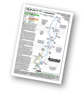
Vital Statistics:
| Length: | 12.25 miles (19.5 km) |
| Ascent: | 4,194ft (1,278m) |
| Time: | 8.75hrs |
| Grade: | |
Route Summary:
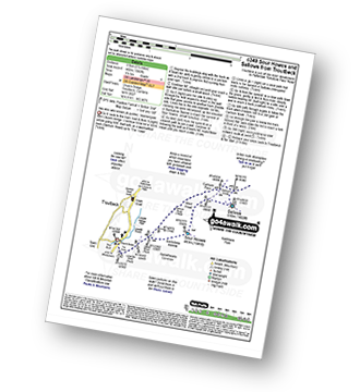
Troutbeck Bridge - Garburn Pass - Yoke - Ill Bell - Froswick - Thornthwaite Crag - Stony Cove Pike (Caudale Moor) - Doup Crag - Trout Beck - Troutbeck Tongue - Hagg Gill - Lowther Brow - Long Green Head - Limefitt Campsite - Troutbeck - Troutbeck Bridge
|
Vital Statistics:
| Length: | 15.5 miles (25 km) |
| Ascent: | 4,293ft (1,308m) |
| Time: | 10 hrs |
| Grade: |  |
Route Summary:
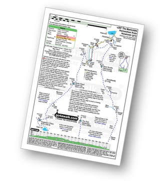
Patterdale - Rooking - Crookabeck - Beckstones - Dubhow - Hartsop - Hayswater Gill - Hayswater - The Knott - Brock Crags - Angle Tarn (Martindale) - Angletarn Pikes - Boredale Hause - Place Fell - High Dodd (Sleet Fell) - Sandwick - Long Crag - Silver Point - Ullswater - Blowick - Rooking - Side Farm - Patterdale
|
Vital Statistics:
| Length: | 12.5 miles (20 km) |
| Ascent: | 3,769ft (1,149m) |
| Time: | 8½ hrs |
| Grade: | |
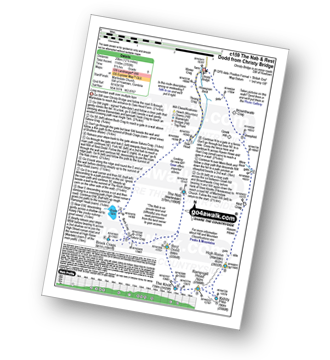
Route Summary:
Christy Bridge - Martindale - Dale Head Farm - Heck Crag - Angle Tarn - Buck Crag - Brock Crags - Satura Crag - The Nab (Martindale) - Rest Dodd - The Knott - Rampsgill Head - Kidsty Pike - High Raise (Mardale) - Red Crag - Keasgill Head - Christy Bridge
|
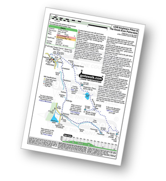
Vital Statistics:
| Length: | 6 miles (9.5 km) |
| Ascent: | 2,192ft (668m) |
| Time: | 5 hrs |
| Grade: |  |
Route Summary:
Ambleside - Stockghyll Force - Wansfell Pike - Baystones (Wansfell) - The Hundreds - Nanny Lane - Troutbeck - Robin Lane - High Skelghyll Farm - Skelghyll Wood - Jenkin Crag - Ambleside
|
Vital Statistics:
| Length: | 10.5 miles (17 km) |
| Ascent: | 3,417ft (1,041m) |
| Time: | 7.25hrs |
| Grade: | |
Route Summary:
Stockdale - Sadgill Bridge - Stockdale Beck - Great Howe - Grey Crag (Sleddale) - Tarn Crag (Sleddale) - Sleddale Fell - Selside Brow - Branstree (Artlecrag Pike) - Gatescarth Pass - Adam Seat - Harter Fell (Mardale) - Kentmere Pike - Goat Scar - Shipman Knotts - Wray Crag - Stockdale
|
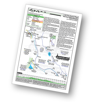
Vital Statistics:
| Length: | 8.5 miles (13.5 km) |
| Ascent: | 2,552ft (778m) |
| Time: | 6 hrs |
| Grade: | |
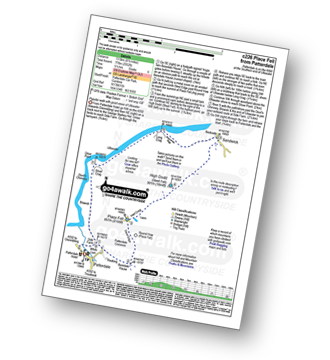
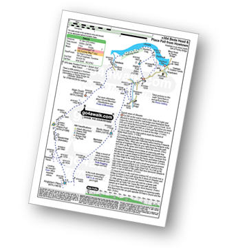
Route Summary:
Patterdale - Rooking - Boredale Hause - Place Fell - High Dodd (Sleet Fell) - Martindale - Sandwick - Long Crag (Ullswater) - Silver Point - Ullswater - Blowick - Rooking - Side Farm - Patterdale
|
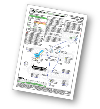
Vital Statistics:
| Length: | 5 miles (8 km) |
| Ascent: | 912ft (278m) |
| Time: | 2.75hrs |
| Grade: | |
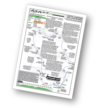
Route Summary:
Howtown - The Coombs - St Peter's Church - Lanty Tarn - Martindale - Christy Bridge - Howegrain Beck - Sandwick Beck - Sandwick - Hallinhag Wood - Geordie's Crag - Waternook - Howtown
|
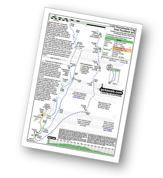
Vital Statistics:
| Length: | 7.5 miles (12 km) |
| Ascent: | 3,131ft (954m) |
| Time: | 5.75hrs |
| Grade: | |
Route Summary:
Cow Bridge - Brothers Water - Hartsop - Hartsop Dodd - Caudale Moor - Caudale Head - Stony Cove Pike (Caudale Moor) - Threshthwaite Mouth - Thornthwaite Crag - Gray Crag (Hayeswater) - Hayeswater Gill - Hartsop - Cow Bridge
|
Vital Statistics:
| Length: | 9 miles (14.5 km) |
| Ascent: | 2,619ft (798m) |
| Time: | 6 hrs |
| Grade: | |
Route Summary:
Patterdale - Side Farm - Boredale Hause - Angletarn Pikes - Angle Tarn (Martindale) - Satura Crag - Brock Crags - Satura Crag - The Knott - Hayeswater Reservoir - Hayeswater Gill - Hartsop - Dubhow - Beckstones - Crookabeck - Rooking - Side Farm - Patterdale
|
Vital Statistics:
| Length: | 12.5 miles (20 km) |
| Ascent: | 3,814ft (1,162m) |
| Time: | 8½ hrs |
| Grade: | |
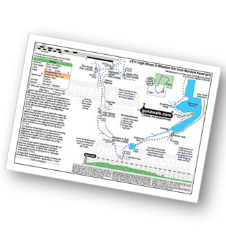
Route Summary:
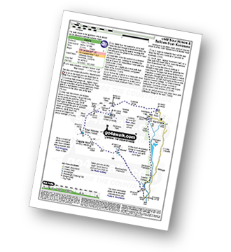
Mardale Head - Haweswater - Rowantreethwaite Beck - Old Corpse Road - Selside Pike - Branstree (North East Top) - Branstree (Artlecrag Pike) - Gatescarth Pass - Adam Seat - Harter Fell (Mardale) - Nan Bield Pass - Mardale Ill Bell - High Street - Riggindale - Rampsgill Head - Wainwright's Coast to Coast Walk - Kidsty Pike - Kidsty Howes - Bowderthaite Bridge - The Rigg - Mardale Head
|
Vital Statistics:
| Length: | 11.5 miles (18.5 km) |
| Ascent: | 3,378ft (1,030m) |
| Time: | 7½ hrs |
| Grade: | |
Route Summary:
Kentmere - Garburn Pass - Yoke - Ill Bell - Froswick - Thornthwaite Crag - Mardale Ill Bell - Nan Bield Pass - Harter Fell (Mardale) - Kentmere Pike - Brookstones - Kentmere
|
Vital Statistics:
| Length: | 12.5 miles (20 km) |
| Ascent: | 3,889ft (1,185m) |
| Time: | 8½ hrs |
| Grade: | |
Route Summary:
Cow Bridge - Brothers Water - Hartsop - Hartsop Dodd - Stony Cove Pike - Caudale Head - Caudale Moor - Stony Cove Pike (Caudale Moor) - Threshthwaite Mouth - Thornthwaite Crag - High Street - Straits of Riggindale - The Knott - Angle Tarn (Martindale) - Angletarn Pikes - Boredale Hause - Patterdale
|
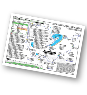
Vital Statistics:
| Length: | 7.25 miles (11.5 km) |
| Ascent: | 2,745ft (837m) |
| Time: | 5½ hrs |
| Grade: | |
Route Summary:
Mardale Head - Haweswater Reservoir - The Rigg - Dudderwick - Swine Crag (Riggindale) - Heron Crag (Riggindale) - Rough Crag (Riggindale) - Caspel Gate - Riggindale Crag - Long Stile - High Street - Mardale Ill Bell - Nan Bield Pass - Harter Fell (Mardale) - Adam Seat - Gatescarth Pass - Mardale Head
|
Vital Statistics:
| Length: | 8.5 miles (13.5 km) |
| Ascent: | 1,994ft (608m) |
| Time: | 5 hrs |
| Grade: | |
Route Summary:
Howtown - Lock Bank - White Knott - Barton Fell - Whinny Crag - Arthur's Pike - Loadpot Hill - Bonscale Pike - Swarthbeck Gill - Howtown
|
Vital Statistics:
| Length: | 14.5 miles (23 km) |
| Ascent: | 4,555ft (1,388m) |
| Time: | 9.75hrs |
| Grade: | |
Route Summary:
St Peter's Church (Martindale) - Howtown - Steel Knotts (Pikeawassa) - Keasgill Head - High Raise (Mardale) - Kidsty Pike - Rampsgill Head - The Knott - Rest Dodd - The Nab - Satura Crag - Brock Crags - Angle Tarn (Martindale) - Angletarn Pikes - Bedafel Knott - Beda Head (Beda Fell) - Winter Crag - Christy Bridge - Howegrain Beck - Martindale - St Peter's Church (Martindale) - Howtown
|
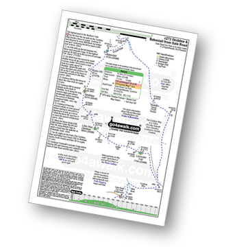
Vital Statistics:
| Length: | 9.75 miles (15.5 km) |
| Ascent: | 3,470ft (1,058m) |
| Time: | 7 hrs |
| Grade: | |
Route Summary:
St Peter's Church (Martindale) - Howtown - Howegrain Beck - Christy Bridge - Beda Head (Beda Fell) - Martindale Common - Angletarn Pikes - Angle Tarn (Martindale) - Boredale Hause - Steel Edge - Place Fell - High Dodd (Sleet Fell) - Sandwick - Hallinhag Wood - Geordies Crag - Hallin Fell (Martindale) - Howtown
|
Vital Statistics:
| Length: | 8.25 miles (13 km) |
| Ascent: | 1,421ft (433m) |
| Time: | 4½ hrs |
| Grade: | |
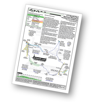
Route Summary:
Troutbeck Bridge - Troutbeck - Limefitt Holiday Park - Long Green Head - Ing Bridge - Troutbeck Park - Park Fell Head - Trout Beck - Troutbeck Tongue - Hagg Gill - Lowther Brow - Long Green Head - Limefitt Holiday Park - Troutbeck - Troutbeck Bridge
|
Vital Statistics:
| Length: | 11 miles (17.5 km) |
| Ascent: | 3,410ft (1,039m) |
| Time: | 7½ hrs |
| Grade: | |
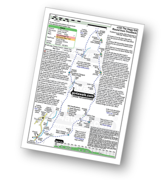
Route Summary:
Troutbeck Bridge - Garburn Road - Backstone Barrow - Sour Howes - Sallows - Garburn Pass - Yoke - Ill Bell - Froswick - Wanfer Crag - Hagg Gill - Trout Beck - Troutbeck Tongue - Lowther Brow - Long Green Head - Limefitt Campsite - Troutbeck - Troutbeck Bridge
|
Vital Statistics:
| Length: | 6 miles (9.5 km) |
| Ascent: | 2,202ft (671m) |
| Time: | 4½ hrs |
| Grade: | |
Route Summary:
Mardale Head - Haweswater Reservoir - The Rigg - Swine Crag (Riggindale) - Heron Crag (Riggindale) - Eagle Crag (Riggindale) - Rough Crag (Riggindale) - Caspel Gate - Riggindale Crag - Long Stile - High Street - Rough Crag (Riggindale) - Eagle Crag (Riggindale) - Heron Crag (Riggindale) - Swine Crag (Riggindale) - Dudderwick - The Rigg - Mardale Head
|
Vital Statistics:
| Length: | 5.5 miles (8.5 km) |
| Ascent: | 1,582ft (482m) |
| Time: | 3.75hrs |
| Grade: | |
Route Summary:
Troutbeck Bridge - Garburn Road - Backstone Barrow - Sour Howes - Sallows - Garburn Pass - Troutbeck - Troutbeck Bridge
|
Vital Statistics:
| Length: | 11.25 miles (18 km) |
| Ascent: | 3,436ft (1,047m) |
| Time: | 7½ hrs |
| Grade: | |
Route Summary:
Mardale Head - Haweswater Reservoir - Rowantreethwaite Beck - Old Corpse Road - Selside Pike - Branstree (North East Top) - Branstree (Artlecrag Pike) - Gatescarth Pass - Adam Seat - Harter Fell (Mardale) - Nan Bield Pass - Mardale Ill Bell - High Street - Riggindale Crag - Caspel Gate - Rough Crag (Riggindale) - Eagle Crag (Riggindale) - Heron Crag (Riggindale) - Swine Crag (Riggindale) - Dudderwick - The Rigg - Mardale Head
|
Vital Statistics:
| Length: | 7.5 miles (12 km) |
| Ascent: | 1,216ft (462m) |
| Time: | 4.25hrs |
| Grade: | |
Route Summary:
Kentmere - Ullthwaite Bridge - Croft Head - Meadowplatts Plantation - Capple Howe - Sour Howes - Sallows - Garburn Pass - Crabtree Brow - Kentmere - kentmere Hall - Hall Wood - Kentmere Plantation - Sawmill Cottage - Ullthwaite Bridge - Kentmere
|
Vital Statistics:
| Length: | 5.75 miles (9 km) |
| Ascent: | 1,260ft (384m) |
| Time: | 3½ hrs |
| Grade: | |
Route Summary:
Kentmere - Cornclose Lane (track) - Rasp Howe - Skeggles Water - Cocklaw Fell - Green Quarter Fell - Hollow Moor (Green Quarter) - Hollow Moor (North East Top) - Kentmere
See this list of walks, routes & maps in:
Grade Order |
Length Order |
Time Order |
Walk Number or Start Location Order
NB. To reverse (toggle) this order, click Grade Order again

To contribute to go4awalk.com or to contact us about anything at all - see Talk To Us. For help see Help.
go4awalk.com and go4awalk.co.uk are registered trademarks of TMDH Limited.
Copyright © 2000-2024 TMDH Limited. All rights reserved.
Copyright | Terms & Conditions | Privacy Statement
A - Z
Walks
Home
Log On/Accounts
Photo Gallery
Walk Ideas and Collections
Fell Facts
Places to Stay
Hill Skills
Walking Questions and Answers
Your Stories
News
Competitions
Product Reviews/Gear Tests
Walking Gear Guides
Peaks and Mountains
Peak Bagging
Find New Walking Friends
Camping
GPS Waypoints for Walking
Walk Search
Talk to us
go4awalk.com Help
Free example walks
Newsletter


