The 30 nearest, easy-to-follow, circular walks, routes & maps to UK Postcode SR4
The thirty nearest, easy-to-follow, circular walks, routes & maps to UK Postcode SR4 in Walk Grade Order
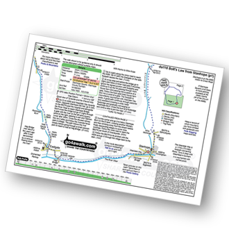
   |
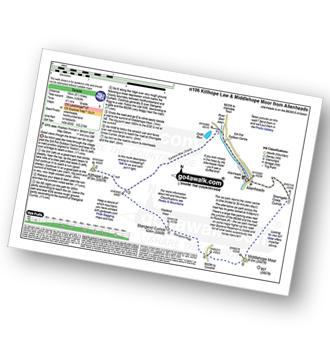
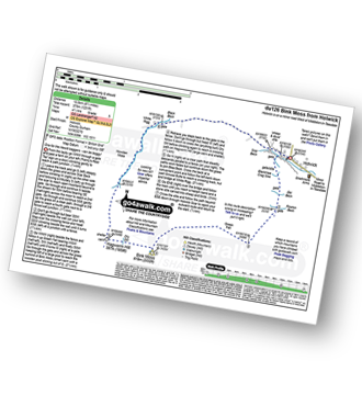
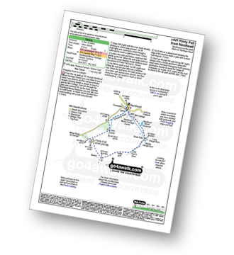
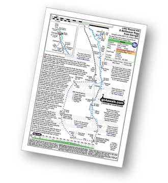
Vital Statistics:
| Length: | 5.5 miles (8.5 km) |
| Ascent: | 46ft (14m) |
| Time: | 2 hrs |
| Grade: |  |
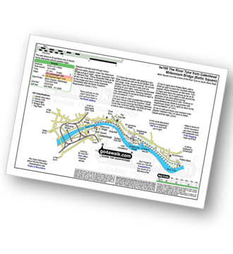
Route Summary:
Baltic Square - Gateshead - Millennium Bridge - Newcastle - Quayside Walk - The Hadrian's Way - The Hadrian's Wall Path - Byker Ouseburn Regeneration Centre - Ouse Burn - Spillars Tyne Mill - Hadrian's Cycle Way - St Anthony's - Pottery Bank - St Peters Marina - Quayside Walk - Newcastle - Millennium Bridge - Gateshead.
|
Vital Statistics:
| Length: | 8.5 miles (13.5 km) |
| Ascent: | 1,093ft (333m) |
| Time: | 4.25hrs |
| Grade: |  |
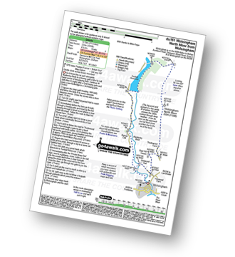
Route Summary:
Wolsingham - Waskerley Beck - Holywood House - Bael Hill House - Thistlewood Farm - Wolsingham North Moor - Tunstall Reservoir - Bishop Oak - Wolsingham
|
Vital Statistics:
| Length: | 10.5 miles (17 km) |
| Ascent: | 853ft (260m) |
| Time: | 4½ hrs |
| Grade: | |
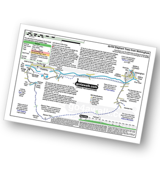
Route Summary:
Wolsingham - River Wear - Weardale - The Weardale Way - Ashes House - Towdy Potts - Spence Hill - Harthope - Sunnyside Edge - Elephant Trees - Pikestone Fell - Allotment House - Folly Plantation - Harehope Farm - White Kirkley Farm - Bolihope Burn - Lower Bishopley Farm - Miln House Farm - Bridge End - Frosterley - Weardale - Wolsingham
|
Vital Statistics:
| Length: | 11 miles (17 km) |
| Ascent: | 1,246ft (380m) |
| Time: | 5.25hrs |
| Grade: |  |
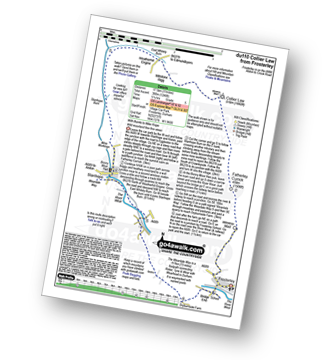
Route Summary:
Frosterley - Wireless Mast - Fatherley Currick - Collier Law - Weatherhill Engine - Heathery Burn - Stanhope Burn - Stanhope - River Wear - Stepping Stones - Weardale - The Weardale Way - Dryburnside Farm - Frosterley
|
Vital Statistics:
| Length: | 14.5 miles (23 km) |
| Ascent: | 1,805ft (550m) |
| Time: | 7.25hrs |
| Grade: |  |
Route Summary:
Stanhope - River Wear - Weardale - The Weardale Way - River Wear - Eastgate - Rookhope Burn - Rookhope - C2C Cycle Route - Longlaw End - Bolt's Law (Hunstanworth) - Weatherhill Engine - East Whitely Beck - Stanhope Burn - Stanhope
|
Vital Statistics:
| Length: | 14 miles (22.5 km) |
| Ascent: | 1,979ft (603m) |
| Time: | 7 hrs |
| Grade: |  |
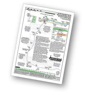
Route Summary:
St John's Chapel - Thatch Mires - Chapelfell Top - Fendrith Hill - Swinhope Moor - Dora's Seat - Swinhope Head - Westernhope Moor - Black Hill (Westernhope Moor) - Littlewood Farm - Brotherlee - Shield - River Wear - Weardale - The Weardale Way - Westgate - Daddry - St John's Chapel
|
Vital Statistics:
| Length: | 9 miles (14.5 km) |
| Ascent: | 1,651ft (503m) |
| Time: | 5 hrs |
| Grade: | |
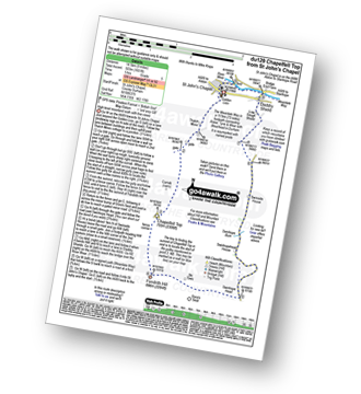
Route Summary:
St John's Chapel - Thatch Mires - Chapelfell Top - Fendrith Hill - Swinhope Moor - Dora's Seat - Swinhope Head - Swinside House - Daddry Shield - River Wear - Weardale - The Weardale Way - St John's Chapel
|
Vital Statistics:
| Length: | 12.75 miles (20.5 km) |
| Ascent: | 1,759ft (536m) |
| Time: | 6½ hrs |
| Grade: | |
Route Summary:
Allenheads - Dirt Pots - The Weardale Way - Killhope Law - Shivery Hill - Carshield Moor - Scum Hill - Hartley Moor - Nan Davison's Cleugh - Philipson's Fold - Knockshield Moor - Black Way (Track) - Swinhope Shield - High Knock Shield - Knock Shield - Knockburn Farm - River East Allen - Low Sipton Shield - Sipton Terrace - Teedham Green - Corn Mill - Low Huntwell - Dirt Pots - Allenheads
|
Vital Statistics:
| Length: | 9.5 miles (15 km) |
| Ascent: | 1,378ft (420m) |
| Time: | 4.75hrs |
| Grade: | |
Route Summary:
Allenheads - Dirt Pots - The Weardale Way - Killhope Law - Stangend Currick - Middlehope Moor - Shorngate Cross - Allenheads
|
Vital Statistics:
| Length: | 9 miles (14.5 km) |
| Ascent: | 1,730ft (527m) |
| Time: | 5 hrs |
| Grade: | |
Route Summary:
Middleton-in-Teesdale - Hudeshope Beck - Skears Lime Kilns - Club Gill Farm - Coldberry Mine - Coldberry Gutter - Hardberry Hill - Stable Edge - Newbiggin - Newbiggin Bridge - The Pennine Way - Park End Wood - Knott Hill - Middle Crossthwaite - The River Tees - Middleton-in-Teesdale
|
Vital Statistics:
| Length: | 8.25 miles (13 km) |
| Ascent: | 1,172ft (357m) |
| Time: | 4.25hrs |
| Grade: | |
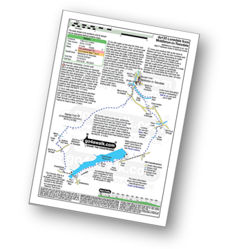
Route Summary:
Middleton-in-Teesdale - River Tees - River Lune - Eller Brook - Grassholme Reservoir - Lunedale - The Pennine Way - Crossthwaite Common - Harter Fell (Crossthwaite Common) - River Tees - Middleton-in-Teesdale
|
Vital Statistics:
| Length: | 17.5 miles (28 km) |
| Ascent: | 1,591ft (485m) |
| Time: | 7.75hrs |
| Grade: | |
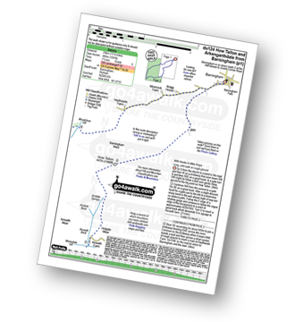
Route Summary:
Barningham - Birk Hills Farm - Brown Hill - Cathaw Stoop - Carter Allotment - Badger Way - Badger Way Stoop - How Tallon - How Tallon Gate - How Tallon Ridge - High Moor - Arndale Springs - Frankinshaw How - Holgate Moor - Arndale hole - Kexwith Beck - Kexwith Farm - Moresdale Gill - Moresdale - Moresdale Road - Fair Seat Hill - Moresdale Ridge - Stony Man (St Andrew's Cross) - Booze Moor - Low Moor - Windeg Vein - Little Windeg - Dry Gill Bottom - Shaw Farm - Stang Side - Stang House - Freestone Ridge - Stang Top - Hope Moor - The Stang - Woodcote Gill - Black Hill Gate - Haythwaite Farm - Moorcock Farm - Bragg House - Barningham
|
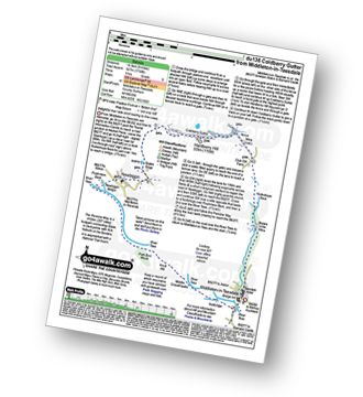
Vital Statistics:
| Length: | 12.5 miles (20 km) |
| Ascent: | 1,279ft (390m) |
| Time: | 5.75hrs |
| Grade: | |
Route Summary:
Bowlees - Wynch Bridge - River Tees - Holwick - Low Currick Rigg - Blea Beck - Whiteholm Bank - Dry Beck - Skyer Beck - Birk Rigg - Thistle Green - White Well Green - River Tees - Fox Earths - Raven Scar - Cronkley Scar - Green Hill - Cronkley Pasture - High House - The Pennine Way - Cronkley Farm - Bracken Rigg - Bleabeck Force - High Force - Saur Hill Bridge - Low Force - Wynch Bridge - Bowlees
|
Vital Statistics:
| Length: | 7.5 miles (12 km) |
| Ascent: | 1,287ft (392m) |
| Time: | 4 hrs |
| Grade: | |
Route Summary:
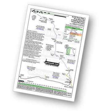
Burnhope Reservoir - Ireshope Moor - Coldberry End - Three Pikes - Coldberry End - Great Stony Hill - Coldberry End - Ireshope Moor - Burnhope Reservoir
|
Vital Statistics:
| Length: | 14 miles (22.5 km) |
| Ascent: | 1,904ft (580m) |
| Time: | 7 hrs |
| Grade: | |
Route Summary:
Burnhope Reservoir - Ireshope Moor - Coldberry End - Three Pikes - Coldberry End - Great Stony Hill - Scaud Hill - Redgleam (Harwood Common) - Burnhope Seat - Dead Stones - White Edge (Burnhope Reservoir) - Lamb's Head - Highwatch Currick - The Malakoff - Bents Head - Stripe End - Burnhope Reservoir
|
Vital Statistics:
| Length: | 11.5 miles (18.5 km) |
| Ascent: | 1,631ft (497m) |
| Time: | 5.75hrs |
| Grade: | |
Route Summary:
Burnhope Reservoir - Ireshope Moor - Coldberry End - Great Stony Hill - Scaud Hill - Redgleam (Harwood Common) - Burnhope Seat - Dead Stones - White Edge (Burnhope Reservoir) - Lamb's Head - Highwatch Currick - The Malakoff - Bents Head - Stripe End - Burnhope Reservoir
|
Vital Statistics:
| Length: | 8.5 miles (13.5 km) |
| Ascent: | 1,231ft (375m) |
| Time: | 4½ hrs |
| Grade: | |
Route Summary:
Holwick - Holwick Scars - Rowton Beck - Green Fell - Bink Moss - Dry Gill - Hagworm Hill - Howden Moss - Black Beck - White Rigg - Holwick
|
Vital Statistics:
| Length: | 8.5 miles (13.5 km) |
| Ascent: | 1,450ft (442m) |
| Time: | 4.75hrs |
| Grade: | |
Route Summary:
Rothbury - The St Oswald's Way - Whitton - Whittondean Farm - Garleigh Moor - Lordenshaws Car Park - The Beacon - Dove Crag - Old stell Crag - Simonside - Bob Pyle's Studdie - Joe's Wood - Great Tosson - The Old Pumphouse - River Coquet - Anton's Letch - Rothbury
|
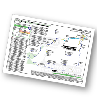
Vital Statistics:
| Length: | 5 miles (8 km) |
| Ascent: | 1,030ft (314m) |
| Time: | 3 hrs |
| Grade: | |
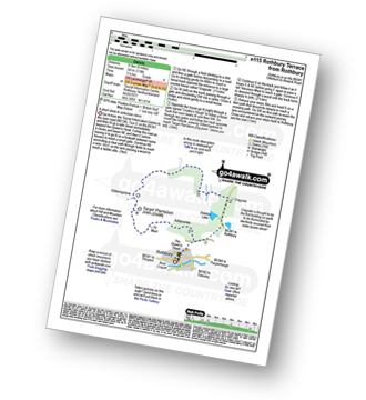
Route Summary:
Rothbury - Blaeberry Hill - Telecommncations Mast - Ship Crag - Brae Head - Target Plantation - Glitteringstone - Rothbury Terrace - Primrose Cottage - Debdon Burn - Debdon Plantation - Tumbleton House - Debden Lake - Tumbleton Lake - Addycombe Farm - Hillside Road - Rothbury
|
Vital Statistics:
| Length: | 4.5 miles (7 km) |
| Ascent: | 387ft (118m) |
| Time: | 2 hrs |
| Grade: |  |
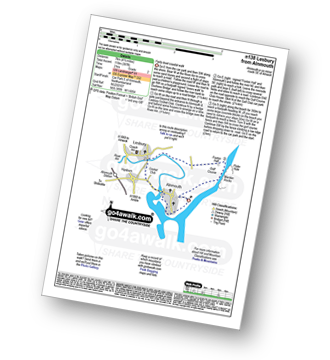
Route Summary:
Alnmouth - Beach - The St Oswald's Way - River Aln - Lesbury - Foxton Hall - Marden Rocks - Alnmouth Golf Club - Alnmouth
|
Vital Statistics:
| Length: | 14 miles (22.5 km) |
| Ascent: | 1,743ft (531m) |
| Time: | 7 hrs |
| Grade: | |
Route Summary:
Langdon Beck - Tarn Hole - Tarn Hole Edge - Three Pikes - Grasshill Common - Causeway Hill - Coldberry Edge - Great Stony Hill - Scaud Hill - Redgleam (Harwood Common) - Swallow Hole - Holdenhurth Band - Herdship Fell - Viewing Hill - Backside Fell Bothy - West Common - Touting Hill - Cow Green Reservoir - Widdybank Fell - Langdon Beck
|
Vital Statistics:
| Length: | 7.75 miles (12.5 km) |
| Ascent: | 988ft (301m) |
| Time: | 4 hrs |
| Grade: | |
Route Summary:
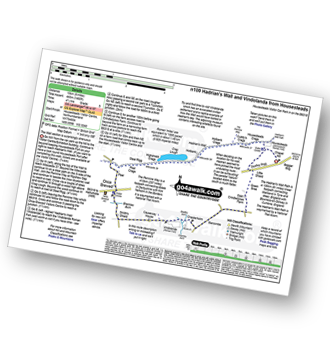
Balderhead Reservoir - High Birk Hat Farm - The Pennine Way - Hannah's Meadow - Birk Hat Farm - Blackton Reservoir - Baldsersdale - Willoughby Hall - Scoon Bank - West Brisco - Coproal Hill - East Brisco - How Beck - Lathe Haw - Lathehaw Rigg - Goldsborough Rigg - Goldsborough - East Friar House - Mawmon Sike - Balckton Grange - Balderhead Reservoir
|
Vital Statistics:
| Length: | 6.25 miles (10 km) |
| Ascent: | 821ft (250m) |
| Time: | 3.25hrs |
| Grade: |  |
Route Summary:
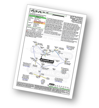
Killhope Cross - Killhope Head - Black Hill - The Dodd - Smallburns Moor - Sunnyside Farm - Coalcleugh Farm - Mufton Hall - Carrshield Moor - Bridge Cleugh - Killhope Law - Killhope Head - Killhope Cross
|
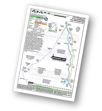
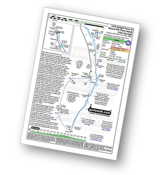
Vital Statistics:
| Length: | 8.25 miles (13 km) |
| Ascent: | 1,460ft (445m) |
| Time: | 4½ hrs |
| Grade: | |
Route Summary:
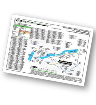
Housteads Visitor Centre - Chapel Hill - Housesteads - Vercovicium Fort - The Hadrian's Wall Path - Housesteads Crags - Cuddy's Crag - The Pennine Way - Hotbank Crags - Hotbank - Crag Lough - Highshield Crags - Steel Rigg - Peel Crags - Peel - Once Brewed - Brackies Burn - Smith's Shield - Causeway House - Vindolanda Roman Fort - Chesterholm - Barcombe - East Crindledykes Farm - Green Brae - Little Shield - Deafley Rigg - Housteads Visitor Centre
|
Vital Statistics:
| Length: | 4 miles (6.5 km) |
| Ascent: | 643ft (196m) |
| Time: | 2.25hrs |
| Grade: | |
Route Summary:
Nenthead - Nenthead Mines Heritage Centre - Shaw Side - Old Carr's Burn - Flinty Fell - Dowgang Hush - Nenthead
|
Vital Statistics:
| Length: | 7.75 miles (12.5 km) |
| Ascent: | 1,250ft (381m) |
| Time: | 4 hrs |
| Grade: | |
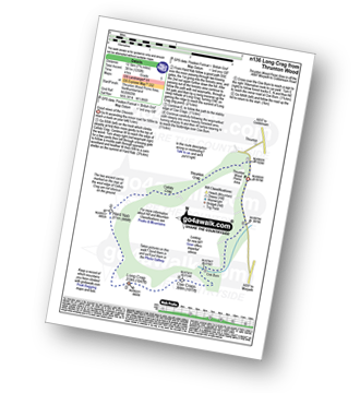
Route Summary:
Thrunton Wood - Callaly Crag - Hard Nab - Long Crag - Coe Crags - Coe Burn - Thrunton Wood
|
Vital Statistics:
| Length: | 15.75 miles (23.5 km) |
| Ascent: | 1,835ft (559m) |
| Time: | 7.25hrs |
| Grade: | |
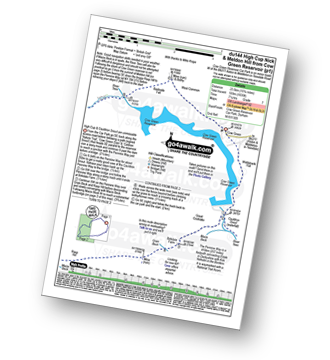
Route Summary:
Cow Green Reservoir - Widdybank Fell - Cauldron Snout - The Pennine Way - Birkdale Farm - Grain Beck - Rasp Hill - Maize Beck - High Cup - High Cup Nick - Stake Beck - Meldon Hill (Dufton Fell) - Force Burn - River Tees - Backside Fell Bothy - Cow Green Reservoir
|
Vital Statistics:
| Length: | 10 miles (16 km) |
| Ascent: | 1,359ft (414m) |
| Time: | 4 hrs |
| Grade: | |
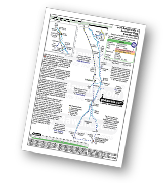
Route Summary:
Garrigill - The Pennine Way - The South Tyne Trail - Low Crossgill - Ash Gill - Ashgill Force - Waterfall - Hole House Farm - Tynehead Farm - Allan's Clough - Bellbeaver Rigg (Tynehead Fell) - Tyne Head - Garrigill
|
Vital Statistics:
| Length: | 11 miles (17.5 km) |
| Ascent: | 1,766ft (538m) |
| Time: | 5.75hrs |
| Grade: | |
Route Summary:
Garrigill - The Pennine Way - The South Tyne Trail - Low Crossgill - Ash Gill - Ashgill Force - Waterfall - Hole House Farm - Tynehead Farm - Allan's Clough - Bellbeaver Rigg (Tynehead Fell) - Tyne Head - Round Hill (Tyne Head) - Noonstones Hill - Dorthgill Farm - Hill House Farm - Lee Houses - Garrigill
|
Vital Statistics:
| Length: | 10.25 miles (16.5 km) |
| Ascent: | 1,408ft (429m) |
| Time: | 5.25hrs |
| Grade: | |
Route Summary:
Garrigill - The Pennine Way - The South Tyne Trail - Low Crossgill - Ash Gill - Ashgill Force - Waterfall - Hole House Farm - Tynehead Farm - Tyne Head - Round Hill (Tyne Head) - Noonstones Hill - Dorthgill Farm - Hill House Farm - Lee Houses - Garrigill


