The 30 nearest, easy-to-follow, circular walks, routes & maps to UK Postcode CO9
The thirty nearest, easy-to-follow, circular walks, routes & maps to UK Postcode CO9 in Walk Grade Order
   |
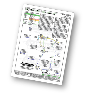
Vital Statistics:
| Length: | 9 miles (14.5 km) |
| Ascent: | 256ft (78m) |
| Time: | 3.75hrs |
| Grade: |  |
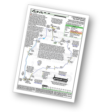
Route Summary:
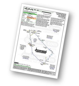
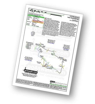
Takeley - Hope End Green - Cow Common - Hellman's Cross - Taverners Green - Hatfield Broad Oak - Three Forests Way - Pincy Brook - Bush End - Harcamlow Way - The Flitch Way - Takeley
|
Vital Statistics:
| Length: | 6.5 miles (10 km) |
| Ascent: | 82ft (25m) |
| Time: | 2½ hrs |
| Grade: |  |
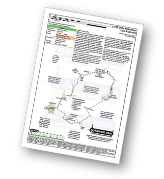
Route Summary:
Fulbourn - Harcamlow Way - Cole's Bridge - New Cut Drain - Hawk Mill Farm - Little Wilbraham - Great Wilbraham - Fleam Dyke - Fulbourn
|
Vital Statistics:
| Length: | 4.5 miles (7 km) |
| Ascent: | 207ft (63m) |
| Time: | 2 hrs |
| Grade: | |
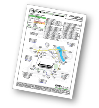
Route Summary:
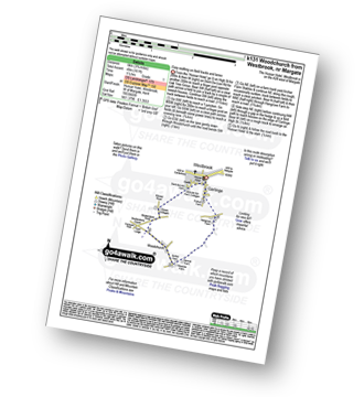
Wherstead - Wherstead Hall - Suffolk Food Hall - Redgate Farm - Freston Brook - The Stour and Orwell Walk - Freston Wood - Freston - Bond Hall Farm - Broom Knoll - Cutler's Wood - Stalls Valley - Valley Farm - Park Farm - Wherstead
|
Vital Statistics:
| Length: | 7 miles (11 km) |
| Ascent: | 650ft (198m) |
| Time: | 3.25hrs |
| Grade: |  |
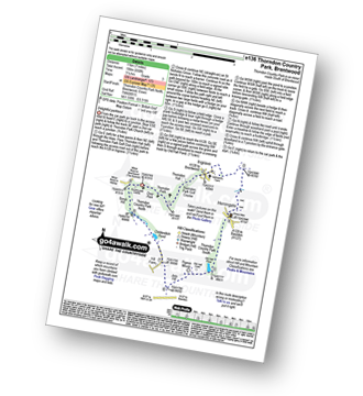
Route Summary:
Thorndon Country Park North - Thorndon Park - Thorndon Hall - Ingrave - Herongate - Thorndon Country Park South - Old Hall Pond - Pigeon Mount - Jury Hill - Childerditch Pond - Scrub Hill - Countryside Centre - Thorndon Country Park North
|
Vital Statistics:
| Length: | 6.25 miles (70 km) |
| Ascent: | 240ft (73m) |
| Time: | 2½ hrs |
| Grade: | |
Route Summary:
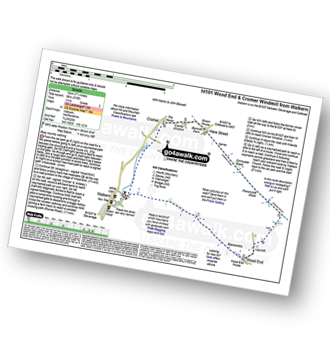
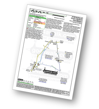
Ardeley - Wood End - Roman Road - Hare Street - Roman Road - Hare Street - Cromer Windmill - Ardeley
|
Vital Statistics:
| Length: | 7.5 miles (12 km) |
| Ascent: | 315ft (96m) |
| Time: | 3 hrs |
| Grade: | |
|
Vital Statistics:
| Length: | 4.75 miles (7.5 km) |
| Ascent: | 249ft (76m) |
| Time: | 2 hrs |
| Grade: | |
|
Vital Statistics:
| Length: | 2.25 miles (3.5 km) |
| Ascent: | 72ft (22m) |
| Time: | 1 hrs |
| Grade: | |
|
Vital Statistics:
| Length: | 4.5 miles (7 km) |
| Ascent: | 295ft (90m) |
| Time: | 2 hrs |
| Grade: | |
Route Summary:
Little Gransden - Waresley - Waresley Wood - Waresley Dean Brook - Gransden Wood - Squirrels' Grove - Gransden Park - Great Gransden - Home Dole Brook - Little Gransden
|
Vital Statistics:
| Length: | 5.5 miles (9 km) |
| Ascent: | 118ft (36m) |
| Time: | 2 hrs |
| Grade: | |
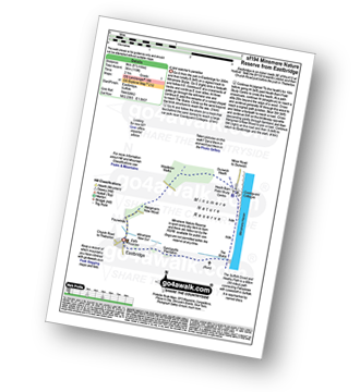
Route Summary:
Eastbridge - Sandpytle Plantation - The Sluice - Minsmere Nature Reserve - Coastguard Cottages - Dunwich Heath - Eastbridge
|
Vital Statistics:
| Length: | 7.25 miles (11.5 km) |
| Ascent: | 840ft (256m) |
| Time: | 3½ hrs |
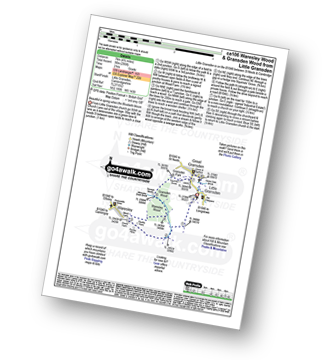
| Grade: |  |
Route Summary:
Romney Street - Courtfield Wood - Eastdown - Great Wood - Paine's Farm - Rowdon Hill - The North Downs Way - Rowdow Wood - Shorehill Farm - Otford Manor - Fab's Wood - Cotman's Ash - Summeryards Wood - Knockmill Wood - Highfield Piggery - Little East Hill Farm - Broom Wood - Romney Street
|
Vital Statistics:
| Length: | 9.5 miles (15 km) |
| Ascent: | 1,306ft (398m) |
| Time: | 4.75hrs |
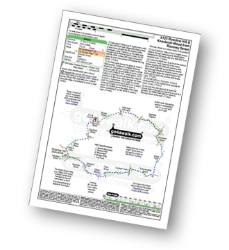
| Grade: |  |
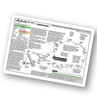
Route Summary:
Otford - The North Downs Way - Otford Mount - Hillydeal Wood - Rowdow Hill - Rowdow Wood - Shorehill Farm - Otford Manor - Fab's Wood - Cotman's Ash - Summeryards Wood - Knockmill Wood - Highfield Piggery - Little East Hill Farm - Broom Wood - Romney Street - Courtfield Wood - Eastdown - Great Wood - Paine's Farm - Greenhill Wood - Otford
|
Vital Statistics:
| Length: | 6.5 miles (10.5 km) |
| Ascent: | 637ft (194m) |
| Time: | 3 hrs |
| Grade: | |
Route Summary:
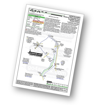
Dunstable Downs Visitors Centre - The Icknield Way - Five Knolls - Drovers Way - Totternhoe - Well Head - Bison Hill - Dunstable Downs Visitors Centre
|
Vital Statistics:
| Length: | 6.5 miles (10 km) |
| Ascent: | 722ft (220m) |
| Time: | 3 hrs |
| Grade: | |
Route Summary:
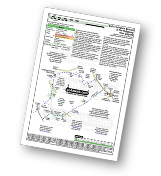
Dagnall - Chlitern Farm - Former Radio Station - Gallows Hill - Ivinghoe Beacon - The Ridgeway - Ivinghoe Hills - Steps Hill - Down Farm - Clipperdown Cottage - Clipper Down - Ward's Hurst Farm - Hog Hall - Hog Hall Lane - Dagnall
|
Vital Statistics:
| Length: | 3.75 miles (6 km) |
| Ascent: | 161ft (49m) |
| Time: | 1½ hrs |
| Grade: | |
Route Summary:
Garlinge - Westbrook - Nr Margate - Minster Rd - Shottendane Rd - Woodchurch - Archer Farm - Hengrove Farm - Garlinge
|
Vital Statistics:
| Length: | 7.25 miles (11.5 km) |
| Ascent: | 381ft (116m) |
| Time: | 3 hrs |
| Grade: | |
Route Summary:
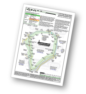
Richmond Park - Pembroke Lodge - Hamcross Plantation - Ham Bottom - Park Gate - Kingston Gate - Robin Hood Gate - Beverley Brook - Roehampton Gate - Adam's Pond - Sheen Gate - The Bog - Richmond Gate - Richmond Park (Richmond Park) - Pembroke Lodge - Richmond Park
|
Vital Statistics:
| Length: | 6.5 miles (10 km) |
| Ascent: | 328ft (100m) |
| Time: | 2½ hrs |
| Grade: | |
Route Summary:
Turvey - Turvey Abbey - Priory Farm - Grotto Plantation - Hill Spinney - Ramacre Wood - Gorewell - The Milton Keynes Boundary Walk - Gullet Wood - Keepers (Church's) Cottage - Woodside - Turvey
|
Vital Statistics:
| Length: | 3.5 miles (5.5 km) |
| Ascent: | 98ft (30m) |
| Time: | 1½ hrs |
| Grade: | |
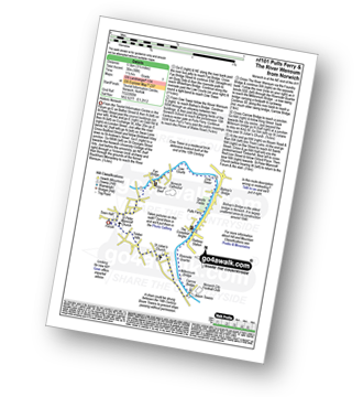
Route Summary:
The Forum - Norwich - The River Wensum - Fye Bridge - Cow Tower - Bishop's Bridge - Pulls Ferry - The Compleat Angler - Foundry Bridge - Millennium Bridge - Lady Julian Bridge - Carrow Bridge - The Devil's Tower (Eastern Boom Tower) - King Street - Wensum Lodge (a.k.a. The Music House) - Dragon Hall - St Peter of Parmentergate church - St Julian's Church - Novi Sad Friendship Bridge - Timber Hills - The Gardeners Arms (a.k.a. The Murderers) - The Lamb - St Peter Mancroft Church - The Guildhall - The Forum - Norwich.
|
Vital Statistics:
| Length: | 6.5 miles (9.5 km) |
| Ascent: | 689ft (210m) |
| Time: | 2.75hrs |
| Grade: | |
Route Summary:
Oxted - The Greensand Way - Limpsfield - The North Downs Way - Tandridge Hill - Townland Pool - Oxted Mill - The Greensand Way - Oxted
|
Vital Statistics:
| Length: | 6.5 miles (10.5 km) |
| Ascent: | 542ft (165m) |
| Time: | 3 hrs |
| Grade: | |
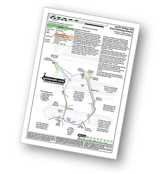
Route Summary:
Farthing Downs - Fairdean Downs - Chaldon Church - Chaldon - The North Downs Way - Ockley Hill - Hilltop House - Willey Park Farm - Caterham - Farthing Downs
|
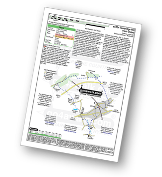
Vital Statistics:
| Length: | 3.75 miles (6 km) |
| Ascent: | 387ft (118m) |
| Time: | 1.75hrs |
| Grade: | |
Route Summary:
Chipstead - Chipstead Bottom - Fames Rough - Perrotts Farm - Ruffett Wood - Chipstead
|
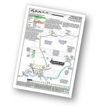
Vital Statistics:
| Length: | 7 miles (11 km) |
| Ascent: | 141ft (43m) |
| Time: | 3 hrs |
| Grade: | |
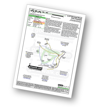
Route Summary:
Haddiscoe - Thorpe Road - Thorpe Hall - Haddiscoe Marshes - Thorpe Marshes - Thorpe and Haddiscoe Fleet - Haddiscoe Cut Bridge - Willow Farm - Marsh Farm - Lower Thurlton - Haddiscoe
|
Vital Statistics:
| Length: | 4 miles (6.5 km) |
| Ascent: | 420ft (128m) |
| Time: | 2 hrs |
| Grade: | |
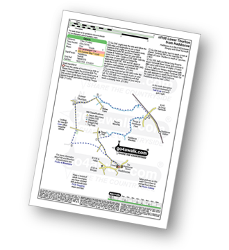
Route Summary:
Godstone - Glebe Water - Church Town - Leigh Place - Oakpark Wood - Tandridge - The Greensand Way - Enterdent - Tilburstowhill Common - Godstone
|
Vital Statistics:
| Length: | 12.5 miles (20 km) |
| Ascent: | 347ft (106m) |
| Time: | 4.75hrs |
| Grade: | |
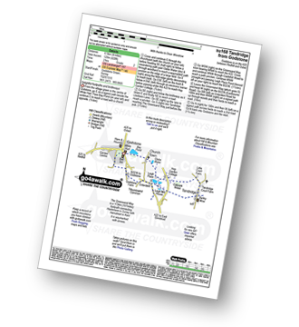
Route Summary:
Reedham - Reedham Chain Ferry - Wherryman's Way - Reedham Drainage Mill - River Yare - Reedham Marshes - Seven Mile House - Polkey's Drainage Mill - Cadge's Drainage Mill - Berney Arms Reach - Berney Arms Mill - The Weavers Way - Berney Marshes - Berney Arms Railway Station - Stone's Drainage Mill - Wickhampton Marshes - Wickhampton - Halvergate Road - Reedham Parish Church - Damgate - Holly Farm Road - Reedham
|
Vital Statistics:
| Length: | 5.25 miles (8.5 km) |
| Ascent: | 407ft (124m) |
| Time: | 2.25hrs |
| Grade: | |
|
Vital Statistics:
| Length: | 4.5 miles (7 km) |
| Ascent: | 453ft (138m) |
| Time: | 2 hrs |
| Grade: | |
|
Vital Statistics:
| Length: | 5 miles (8 km) |
| Ascent: | 230ft (70m) |
| Time: | 2 hrs |
| Grade: | |
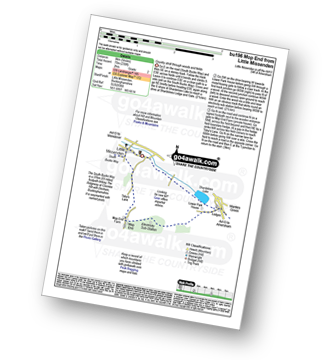
Route Summary:
Little Missenden - The South Bucks Way - Lower Park - Shardeloes Lake - Amersham Cricket Ground - Lower Park House - Wheatley Wood - Mop End - Mop End Farm - Taby's Lane - Breaches Wood - Little Missenden
|
Vital Statistics:
| Length: | 5.5 miles (9 km) |
| Ascent: | 466ft (142m) |
| Time: | 2½ hrs |
| Grade: | |
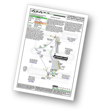
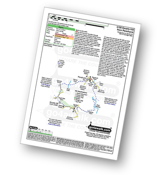
Route Summary:
Tattenham Corner - Epsom Downs Racecourse - Langley Cale - The Warren - Nohome Farm - Downs View Wood - Walton On The Hill - The Nere - Withybed Corner - Walton Downs - Tattenham Corner - Epsom Downs Racecourse.
|
Vital Statistics:
| Length: | 8.25 miles (13 km) |
| Ascent: | 919ft (280m) |
| Time: | 4 hrs |
| Grade: | |
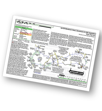
Route Summary:
The Lee - Kiln Cottage - Lee Gate - The Chiltern Way - Durham Farm - Wendoverdean Farm - Wendover Dean - Mayortorne Manor - Russell Farm - Dunsmore - Scrub Wood - Hampdenleaf Wood - The Icknield Way - Little Hampden Common - Little Hampden - The South Bucks Way - Cobblershill Farm - The Chiltern Way - Cockshoots Wood - Mayortorne Manor - Spinney Cottage - The Lee
|
Vital Statistics:
| Length: | 4.5 miles (7 km) |
| Ascent: | 345ft (105m) |
| Time: | 2 hrs |
| Grade: | |
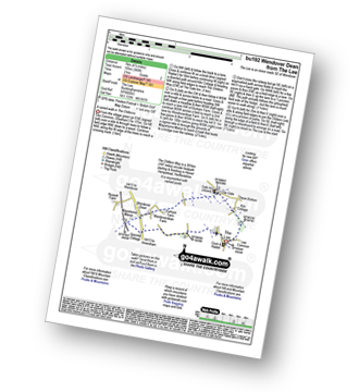
Route Summary:
The Lee - Kiln Cottage - Lee Gate - The Chiltern Way - Durham Farm - Wendoverdean Farm - Wendover Dean - Mayortorne Manor - Spinney Cottage - The Lee


