36 easy-to-follow circular walks in Cornwall
Thirty-six easy-to-follow hand-crafted circular walks, routes & maps in Cornwall of all grades in Walk Grade Order
See this list of walks, routes & maps in:
Grade Order | Length Order | Time Order | Walk Number or Start Location Order
NB. To reverse (toggle) this order, click Grade Order again
   |
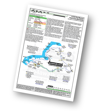
Vital Statistics:
| Length: | 6 miles (9.5 km) |
| Ascent: | 1,076ft (328m) |
| Time: | 3.25hrs |
| Grade: |  |
Route Summary:
Pelynt - Outways Farm - Tregarrick Mill - Muchlarnick - Yearle's Wood - West Looe River - Sowden's Bridge - Trelawne Mill - Kiln Wood - Cathrinepark Wood - Pelynt
|
Vital Statistics:
| Length: | 5.25 miles (8.5 km) |
| Ascent: | 1,260ft (384m) |
| Time: | 3.25hrs |
| Grade: | |

Route Summary:
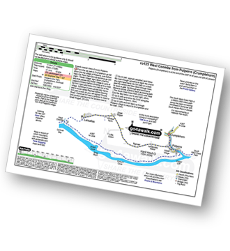
Crumplehorn - Longcoombe Mill - Watergate House - Sclerder Abbey - Porthallow - Talland Bay - The South West Coast Path - Downend Point - Polperro - Crumplehorn
|
Vital Statistics:
| Length: | 5 miles (8 km) |
| Ascent: | 955ft (291m) |
| Time: | 3 hrs |
| Grade: |  |

Route Summary:
Land's End - The South West Coast Path - Mill Bay (Nanjizal) - Trevilley - Trevescan - Sennen - Sennen Cove - Land's End
|
Vital Statistics:
| Length: | 7.5 miles (12 km) |
| Ascent: | 1,533ft (467m) |
| Time: | 4.25hrs |
| Grade: |  |

Route Summary:
Millpool Car Park - West Looe - East Looe - The South West Coast Path - Hannafore Point - Portnadler Bay - Hore Stone - Talland Bay - Talland Church - Tencreek Campsite - Parkers Cross - Kilminorth - Watergate - West Looe River - Kilminorth Wood - West Looe - East Looe.
|
Vital Statistics:
| Length: | 3.75 miles (6 km) |
| Ascent: | 630ft (192m) |
| Time: | 2 hrs |
| Grade: |  |

Route Summary:
Duloe - Duloe Stone Circle - Gillhill Wood - West Looe River - Tremadart Wood - Churchbridge - Duloe
|
Vital Statistics:
| Length: | 8 miles (12 km) |
| Ascent: | 1,759ft (536m) |
| Time: | 4½ hrs |
| Grade: | |
Route Summary:
Crumplehorn - Polperro - Landaviddy Manor - Raphael - Great Tregue - Lansallos - West Coombe - The South West Coast Path - East Coombe - Broad Cove - Shag Rock - Colours Cove - Chapel Cliff - Polperro - Crumplehorn
|
Vital Statistics:
| Length: | 5.5 miles (9 km) |
| Ascent: | 1,407ft (448m) |
| Time: | 3½ hrs |
| Grade: | |

Route Summary:
Crumplehorn - Polperro - Landaviddy Manor - Raphael - Little Lizzen - East Coombe - The South West Coast Path - East Coombe - Broad Cove - Shag Rock - Colours Cove - Chapel Cliff - Polperro - Crumplehorn
|
Vital Statistics:
| Length: | 6.25 miles (10 km) |
| Ascent: | 1,122ft (342m) |
| Time: | 3½ hrs |
| Grade: | |

Route Summary:
Millpool Car Park - West Looe - East Looe - The South West Coast Path - Hannafore Point - Portnadler Bay - Hore Stone - Talland Bay - Talland Church - Tencreek Campsite - Portlooe - West Looe - East Looe.
|
Vital Statistics:
| Length: | 7.25 miles (11.5 km) |
| Ascent: | 1,119ft (341m) |
| Time: | 3.75hrs |
| Grade: | |
Route Summary:
Duloe - Duloe Stone Circle - Gillhill Wood - West Looe River - Tremadart Wood - Churchbridge - Pendruffle Wood - Herodsfoot - Carglonnon Farm - Black Down - Bodbrane Farm - Polvean Cross - Duloe
|
Vital Statistics:
| Length: | 11 miles (17.5 km) |
| Ascent: | 1,657ft (505m) |
| Time: | 5½ hrs |
| Grade: |  |
Route Summary:
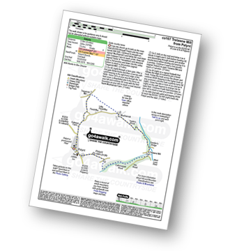
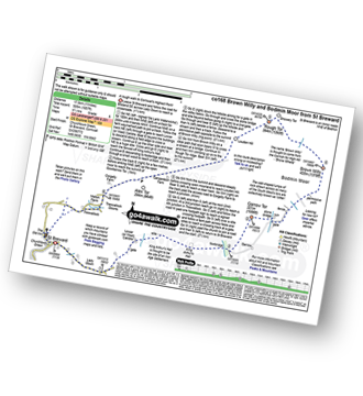
St Breward - Churchtown - Lady Down - West Candra - Lower Candra - King Arthur's Hall - Bodmin Moor - Garrow Tor - Butter's Tor - Brown Willy - Little Rough Tor - Rough Tor - Louden Hill - Alex Tor - Treswallock - St Breward
|
Vital Statistics:
| Length: | 6.25 miles (10 km) |
| Ascent: | 945ft (288m) |
| Time: | 3.25hrs |
| Grade: | |

Route Summary:
Padstow - Padstow Harbour - The South West Coast Path - St Saviour's Point - St George's Cove - Gun Point - Harbour Cove - Hawker's Cove - The Narrows - Old Boad - Stepper Point - Stepper Point Beacon - Crams - Pepper Hole - Butter Hole - Ginver Head - Middle Merope Islands - Crugmeer - Tregirls Farm - Prideaux Place - Padstow - Padstow Harbour.
|
Vital Statistics:
| Length: | 11.75 miles (19 km) |
| Ascent: | 1,867ft (569m) |
| Time: | 6.25hrs |
| Grade: | |
Route Summary:
Rock (Padstow Bay) - The South West Coast Path - Brea Hill - Daymer Bay (Trebetherick) - Trebetherick Point - Greenaway Beach - Broadagogue Cove - Hayle Bay - Trebetherick - Polzeath - New Polzeath - Slipper Point - Pentireglaze Haven - Pentire Point - Pentire Head - Guglane - Rumps Point - Sandinway Beach - Com Head - Pengrit Cove - Downhedge Cove - Pentireglaze - Portkillock Farm - Roserrow - Pityme - Splatt - Stoptide - Rock (Padstow Bay)
|
Vital Statistics:
| Length: | 7.5 miles (12 km) |
| Ascent: | 1,109ft (338m) |
| Time: | 4 hrs |
| Grade: | |
Route Summary:
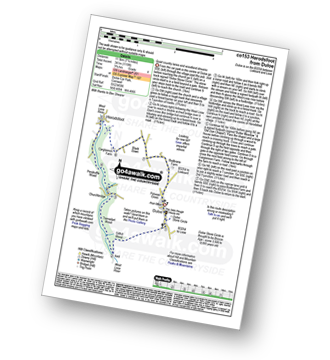
Fivelanes - Five Lanes - Altarnun - Penpont Water - Penhallow Manor - Higher Tregunnon Farm - River Inny - Laneast - Treroose - Trespearne - Gimblett's Mill - River Inny - Trethinna - Trerithick - Little Trenarrett - Penpont Water - Tresmaine - Altarnun - Fivelanes
|
Vital Statistics:
| Length: | 7.25 miles (11.5 km) |
| Ascent: | 1,260ft (384m) |
| Time: | 4 hrs |
| Grade: | |
Route Summary:
Luckett - Treovitown Farm - New Mill Cottage - Lower Clitters House - South Kit Hill Mine - Kit Hill - Kit Hill Quarry - Downgate - Old Mill Cottage - New Mill Cottage - Luckett
|
Vital Statistics:
| Length: | 4.5 miles (7 km) |
| Ascent: | 561ft (171m) |
| Time: | 2.25hrs |
| Grade: | |
Route Summary:
Fivelanes - Five Lanes - Altarnun - Penpont Water - Penhallow Manor - Higher Tregunnon Farm - Lower Tregunnon - Trenarrett - Penpont Water - Tresmaine - Altarnun - Fivelanes
|
Vital Statistics:
| Length: | 5 miles (8 km) |
| Ascent: | 673ft (205m) |
| Time: | 2½ hrs |
| Grade: | |
Route Summary:
Laneast - Treroose - Trespearne - Gimblett's Mill - River Inny - Trethinna - Trerithick - Trenarrett - Lower Tregunnon - Higher Tregunnon Farm - River Inny - Laneast
|
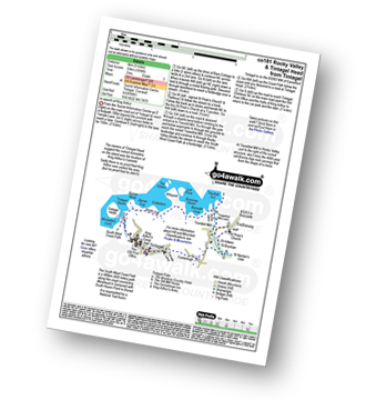
Vital Statistics:
| Length: | 11.25 miles (18 km) |
| Ascent: | 3,197ft (974m) |
| Time: | 7½ hrs |
| Grade: |  |
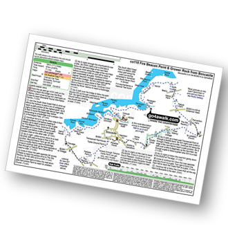
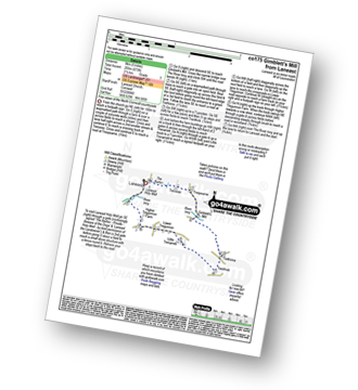
Route Summary:
Boscastle - The South West Coast Path - River Valency - Boscastle Harbour - Penally Point - Penally Hill - Pentargon Bay - Pentargon Falls - Beeny Cliff - Seals Hole - Fire Beacon Point - Beeny - Trebyla Farm - Penvention Farm - St Julietta's Church - River Valency - Minster Wood - Upper Boscastle - Trehane Farm - Trevalga - The South West Coast Path - Grower Rock - Grower Gut - Western Blackapit - Willapark - Boscastle Harbour - Boscastle
|
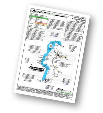
Vital Statistics:
| Length: | 10.75 miles (17 km) |
| Ascent: | 1,983ft (568m) |
| Time: | 5.75hrs |
| Grade: | |
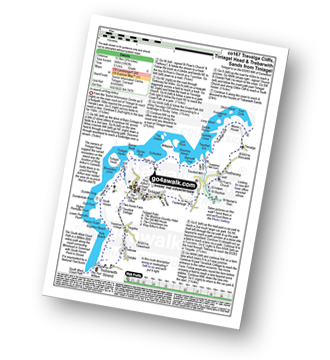
Route Summary:
Tintagel - Fenterleigh - St Nectan's Glen - St Piran's Church - Trethevey - Trevalga - The South West Coast Path - Ladies Window - Trevalga Cliff - Trewthet Gut - Trewethett Mill - Rocky Valley - Benoath Cove - Bossiney Haven - Gullastern - Smith Cliff - Barras Gut - Barras Nose - Tintagel Haven - Tintagel Head - Glebe Cliff - Dunderhole Point - Penhallic Point - Hole Beach - Trebarwith Sands - Trelake - Treknow - Two Acre Farm - Tintagel
|
Vital Statistics:
| Length: | 6.25 miles (10 km) |
| Ascent: | 1,729ft (527m) |
| Time: | 4 hrs |
| Grade: | |

Route Summary:
Boscastle - River Valency - Minster Wood - Upper Boscastle - Trehane Farm - Trevalga - The South West Coast Path - Grower Rock - Grower Gut - Western Blackapit - Willapark - Boscastle Harbour - Boscastle
|
Vital Statistics:
| Length: | 6.5 miles (10 km) |
| Ascent: | 755ft (230m) |
| Time: | 3 hrs |
| Grade: | |
Route Summary:
Rock (Padstow Bay) - Porthilly Cove - Stoptide - Rock (Padstow Bay) - St Endoc Golf Course - St Endoc Church - Trebetherick - The South West Coast Path - Broadagogue Cove - Greenaway Beach - Padstow Bay - Daymer Bay (Trebetherick) - Brea Hill - Rock (Padstow Bay)
|
Vital Statistics:
| Length: | 7 miles (11 km) |
| Ascent: | 1,789ft (545m) |
| Time: | 4½ hrs |
| Grade: | |
Route Summary:
Boscastle - The South West Coast Path - River Valency - Boscastle Harbour - Penally Point - Penally Hill - Pentargon Bay - Pentargon Falls - Beeny Cliff - Seals Hole - Fire Beacon Point - Beeny - Trebyla Farm - Penvention Farm - St Julietta's Church - River Valency - Boscastle
|
Vital Statistics:
| Length: | 4.75 miles (7.5 km) |
| Ascent: | 807ft (246m) |
| Time: | 2½ hrs |
| Grade: | |
Route Summary:
Tintagel - Tintagel Castle - Tintagel Haven - Tintagel Head - Glebe Cliff - Dunderhole Point - Penhallic Point - Hole Beach - Trebarwith Sands - Trelake - Treknow - Two Acre Farm - Tintagel
|
Vital Statistics:
| Length: | 6.75 miles (11 km) |
| Ascent: | 1,234ft (376m) |
| Time: | 3.75hrs |
| Grade: | |

Route Summary:
Tintagel - Fenterleigh - St Nectan's Glen - St Piran's Church - Trethevey - Trevalga - The South West Coast Path - Ladies Window - Trevalga Cliff - Trewthet Gut - Trewethett Mill - Rocky Valley - Benoath Cove - Bossiney Haven - Gullastern - Smith Cliff - Barras Gut - Barras Nose - Tintagel Haven - Tintagel Castle - Tintagel Head - Tintagel
|
Vital Statistics:
| Length: | 5 miles (8 km) |
| Ascent: | 1,096ft (334m) |
| Time: | 3 hrs |
| Grade: | |
Route Summary:
Tintagel - Fenterleigh - St Nectan's Glen - St Piran's Church - Trethevey - Trevelleit Mill - Trewethett Mill - Rocky Valley - The South West Coast Path - Benoath Cove - Bossiney Haven - Gullastern - Smith Cliff - Barras Gut - Barras Nose - Tintagel Haven - Tintagel Castle - Tintagel Head - Tintagel
|
Vital Statistics:
| Length: | 3.25 miles (5 km) |
| Ascent: | 765ft (233m) |
| Time: | 2 hrs |
| Grade: | |
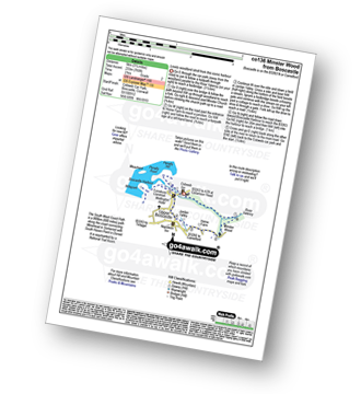
Route Summary:
Boscastle - River Valency - Minster Wood - Jordan Valley - Upper Boscastle - Boscastle Harbour - Boscastle
|
Vital Statistics:
| Length: | 4 miles (6.5 km) |
| Ascent: | 391ft (119m) |
| Time: | 2 hrs |
| Grade: | |

Route Summary:
Daymer Bay (Trebetherick) - The South West Coast Path - Brea Hill - Rock (Padstow Bay) - St Endoc Golf Course - St Endoc Church - Daymer Bay (Trebetherick)
|
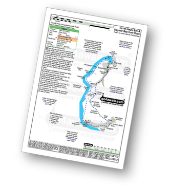
Vital Statistics:
| Length: | 8.25 miles (13.5 km) |
| Ascent: | 958ft (292m) |
| Time: | 4 hrs |
| Grade: | |
Route Summary:
Daymer Bay (Trebetherick) - The South West Coast Path - Trebetherick Point - Greenaway Beach - Broadagogue Cove - Hayle Bay - Trebetherick - Polzeath - New Polzeath - Slipper Point - Pentireglaze Haven - Pentireglaze - Portkillock Farm - Roserrow - Pityme - Splatt - Stoptide - Rock (Padstow Bay) - St Endoc Church - Daymer Bay (Trebetherick)
|
Vital Statistics:
| Length: | 5.5 miles (9 km) |
| Ascent: | 1,208ft (368m) |
| Time: | 3½ hrs |
| Grade: | |

Route Summary:
Trebetherick - The South West Coast Path - Polzeath - New Polzeath - Slipper Point - Pentireglaze Haven - Pentire Point - Pentire Head - Guglane - Rumps Point - Sandinway Beach - Com Head - Pengrit Cove - Downhedge Cove - Pentireglaze - Polzeath - Trebetherick
|
Vital Statistics:
| Length: | 7.75 miles (12.5 km) |
| Ascent: | 1,306ft (398m) |
| Time: | 4.25hrs |
| Grade: | |
Route Summary:
Holywell - Ellenglaze - Trebisken House - Mount Farm - Penhale Sands (Dunes) - St Prian's Church (Penhale Sands) - St Piran's Oratory (Penhale Sands) - The South West Coast Path - Perran Beach - Liggar Bay - Perran Bay - Liggar Point - Hoblyn's Cove - Penhale Point - Holywell Bay - Holywell
|
Vital Statistics:
| Length: | 4.75 miles (7.5 km) |
| Ascent: | 876ft (267m) |
| Time: | 2½ hrs |
| Grade: | |

Route Summary:
West Pentire - The South West Coast Path - Pentire Point West - Porth Joke - Kelsey Head - Holywell Bay - Holywell Beach - Holywell - The Kelseys - Cuthbert Common - West Pentire
|
Vital Statistics:
| Length: | 7.25 miles (11.5 km) |
| Ascent: | 1,805ft (550m) |
| Time: | 4½ hrs |
| Grade: | |
Route Summary:
Port Isaac - Port Gaverne - Trewetha - Trelights - Rosecarrock Farm - Port Quin - Kellan Head - Downgate Cove - Greengarden Cove - Varley Head - Varley Sands - Pine Haven - Lobber Point - Port Isaac
|
Vital Statistics:
| Length: | 7 miles (11 km) |
| Ascent: | 1,086ft (331m) |
| Time: | 3.75hrs |
| Grade: | |

Route Summary:
Mawgan Porth - Bracken Cott - Vale of Mawgan - St Mawgan - Trevarrian - Tregurrian - Watergate Bay - The South West Coast Path - Ontonna Rock - Stem Point - Griffin's Point - Beacon Cove - Berryl's Point - Butt Rock - Grange Point - Mawgan Porth
|
Vital Statistics:
| Length: | 5.5 miles (9 km) |
| Ascent: | 700ft (213m) |
| Time: | 2.75hrs |
| Grade: | |

Route Summary:
Perranuthnoe - The South West Coast Path - Perran Sands - Maen-du-Point - The Greeb - Basore Point - Trenow Cove - Venton Farm - Chymorvah East - Marazion - The Causeway - St Michael's Mount - He Causeway - Marazion - Trenow Farm - Perranuthnoe
|
Vital Statistics:
| Length: | 4.5 miles (7 km) |
| Ascent: | 748ft (228m) |
| Time: | 2½ hrs |
| Grade: | |
Route Summary:
Pentire Farm - Porth Mear - The South West Coast Path - High Cove - Park Head - Mackerel Cove - Pentire Steps - Diggory's Island - Bedruthan Steps - Pendarve Point - Whitestone Cove - Bedruthan Steps Visitor Centre - B3276 - Pentire Farm
|
Vital Statistics:
| Length: | 6 miles (9.5 km) |
| Ascent: | 1,382ft (421m) |
| Time: | 3.75hrs |
| Grade: | |

Route Summary:
Cawsand - The South West Coast Path - Cawsand Bay - Pier Cellars - Penlee Point - Homebarton Hill - Rame Head - Queener Point - Polhawn Cove - Captain Blake's Point - Wiggle Cliff - Wiggle - Wringford Downs Cawsand.
|
Vital Statistics:
| Length: | 5 miles (8 km) |
| Ascent: | 952ft (290m) |
| Time: | 2.75hrs |
| Grade: | |
Route Summary:
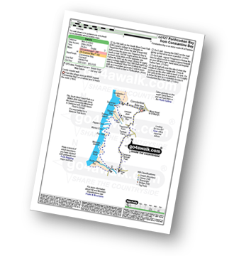
Constantine Bay - The South West Coast Path - Treyarnon Point - Treyarnon Bay - Trethias Island - Pepper Cove - Warren Cove - Fox Cove - Minnows Islands - Will's Rock - Porthcothan Bay - Carnevas - Trethias Farm - Treyarnon Farm - Constantine Bay
See this list of walks, routes & maps in:
Grade Order | Length Order | Time Order | Walk Number or Start Location Order
NB. To reverse (toggle) this order, click Grade Order again


