3 easy to follow walk route maps of all grades that include part of The Marches Way
The Marches Way is a 329km (204 miles) linear footpath connecting Chester in Cheshire, England with Cardiff in Cardiff, England. The Marches Way is waymarked by named posts.
   |
Vital Statistics:
| Length: | 7.75 miles (12.5 km) |
| Ascent: | 1,083ft (330m) |
| Time: | 4 hrs |
| Grade: |  |
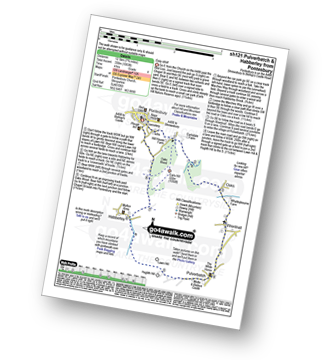
Route Summary:
Pontesbury - Oaks Wood - The Marches Way - Oaks - Wrentnall - Pulverbatch - Habberley - Pontesbury
|
Vital Statistics:
| Length: | 9 miles (14.5 km) |
| Ascent: | 797ft (243m) |
| Time: | 4.25hrs |
| Grade: | |
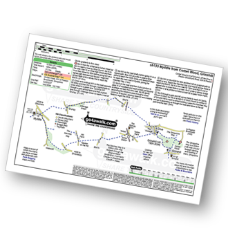
Route Summary:
Corbet Wood - Grinshill - Clive - Grumpy - Myddle - The Marches Way - Webscott - Newton on the Hill - Yorton - Clive - Grinshill - The Shropshire Way - Corbet Wood - Grinshill
|
Vital Statistics:
| Length: | 6 miles (9.5 km) |
| Ascent: | 351ft (107m) |
| Time: | 2½ hrs |
| Grade: |  |
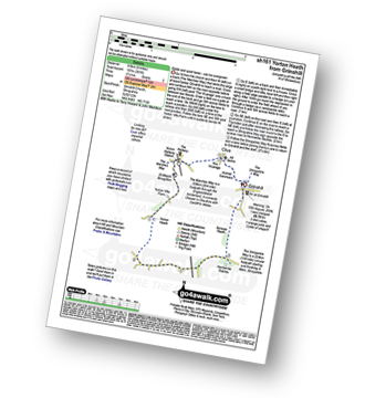
Route Summary:
Grinshill - The Marches Way - Yorton Villa Farm - Yorton House Farm - Yorton Heath - Sansaw Heath - Sheepcotes - Sansaw Business Park - The Shropshire Way - Grinshill
To contribute to go4awalk.com or to contact us about anything at all - see Talk To Us. For help see Help.
go4awalk.com and go4awalk.co.uk are registered trademarks of TMDH Limited.
Copyright © 2000-2024 TMDH Limited. All rights reserved.
Copyright | Terms & Conditions | Privacy Statement
A - Z
Walks
Home
Log On/Accounts
Photo Gallery
Walk Ideas and Collections
Fell Facts
Places to Stay
Hill Skills
Walking Questions and Answers
Your Stories
News
Competitions
Product Reviews/Gear Tests
Walking Gear Guides
Peaks and Mountains
Peak Bagging
Find New Walking Friends
Camping
GPS Waypoints for Walking
Walk Search
Talk to us
go4awalk.com Help
Free example walks
Newsletter


