3 easy to follow walk route maps of all grades that include part of The Granite Way
The Granite Way is an 18km (11 miles) linear footpath connecting Okehampton in Devon, England with Lydford in Devon, England. The Granite Way is waymarked by named posts.
   |
Vital Statistics:
| Length: | 9.5 miles (15.5 km) |
| Ascent: | 1,638ft (499m) |
| Time: | 5.25hrs |
| Grade: |  |
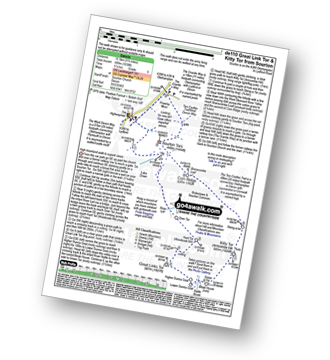
Route Summary:
Sourton - Sourton Church - River Lyd - Gren Tor - Hunt Tor - Woodcock Hill - Great Links Tor - Higher Dunna Goat - Lower Dunna Goat - Rattle Brook - Green Tor - Kitty Tor (Amicombe Hill) - Amicombe Hill - Steng-a-tor - Corn Ridge - Branscombe Loaf - Sourton Tors - Two Castles Trail - The West Devon Way - Prewley Moor - The Granite Way - Sourton Church.
|
Vital Statistics:
| Length: | 6.5 miles (10.5 km) |
| Ascent: | 1,188ft (362m) |
| Time: | 3.75hrs |
| Grade: |  |
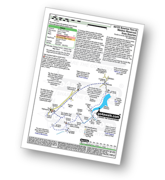
Route Summary:
Sourton - Sourton Church - Two Castles Trail - The West Devon Way - Sourton Tors - Vellake Brook - West Okement River - Vellake Weir - Meldon Reservoir - Downside - The Granite Way - Prewley Moor - Sourton Church.
|
Vital Statistics:
| Length: | 8.25 miles (13 km) |
| Ascent: | 1,375ft (419m) |
| Time: | 4½ hrs |
| Grade: |  |
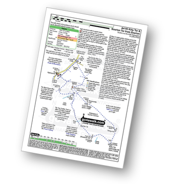
Route Summary:
Sourton - Sourton Church - River Lyd - Gren Tor - Hunt Tor - Woodcock Hill - Rattle Brook - Kitty Tor (Amicombe Hill) - Amicombe Hill - Sten-a-tor - Corn Ridge - Sourton Tors - Two Castles Trail - The West Devon Way - Prewley Moor - The Granite Way - Sourton Church.
To contribute to go4awalk.com or to contact us about anything at all - see Talk To Us. For help see Help.
go4awalk.com and go4awalk.co.uk are registered trademarks of TMDH Limited.
Copyright © 2000-2024 TMDH Limited. All rights reserved.
Copyright | Terms & Conditions | Privacy Statement
A - Z
Walks
Home
Log On/Accounts
Photo Gallery
Walk Ideas and Collections
Fell Facts
Places to Stay
Hill Skills
Walking Questions and Answers
Your Stories
News
Competitions
Product Reviews/Gear Tests
Walking Gear Guides
Peaks and Mountains
Peak Bagging
Find New Walking Friends
Camping
GPS Waypoints for Walking
Walk Search
Talk to us
go4awalk.com Help
Free example walks
Newsletter


