Walks Routes Maps from Langsett Barn Car Park in The Dark Peak Area, The Peak District, South Yorkshire in Walk Grade Order
Route maps for Walks that start, or go through, Langsett Barn Car Park in The Dark Peak Area, The Peak District, South Yorkshire, England in Walk Grade Order
Details of refreshments, pubs & parking are included on each Langsett Barn Car Park walk description.
   |
Vital Statistics:
| Length: | 3.75 miles (6.5 km) |
| Ascent: | 673ft (205m) |
| Time: | 2.25hrs |
| Grade: |  |
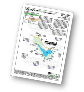
Route Summary:
Langsett Barn Car Park - Langsett - Langsett Reservoir Dam - Upper Midhope - Thickwoods - Thickwoods Brook - North America Farm - Delf Edge - Langsett Reservoir - The Porter or Little Don River - Crookland Wood - Langsett Reservoir - Langsett Barn Car Park
|
Vital Statistics:
| Length: | 7.5 miles (12 km) |
| Ascent: | 1,118ft (360m) |
| Time: | 4 hrs |
| Grade: |  |
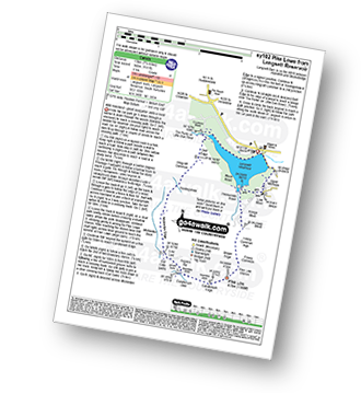
Route Summary:
Langsett Barn Car Park - Langsett - Langsett Reservoir - Langsett Reservoir Dam - Upper Midhope - Thickwoods - Thickwoods Brook - Fenny Common Ings - Fenny Common - Pike Lowe Stones - Pike Lowe - Candlerush Edge - Sugden Top - Lost Lad (Langsett) - Mickleden Edge (Langsett) - Haslingshaw Hingcliff Common - Delf Edge - Langsett Reservoir - The Porter or Little Don River - Crookland Wood - Langsett Reservoir - Langsett Barn Car Park
Find more fantastic easy-to-follow circular walks in The Peak District
To contribute to go4awalk.com or to contact us about anything at all - see Talk To Us. For help see Help.
go4awalk.com and go4awalk.co.uk are registered trademarks of TMDH Limited.
Copyright © 2000-2024 TMDH Limited. All rights reserved.
Copyright | Terms & Conditions | Privacy Statement
A - Z
Walks
Home
Log On/Accounts
Photo Gallery
Walk Ideas and Collections
Fell Facts
Places to Stay
Hill Skills
Walking Questions and Answers
Your Stories
News
Competitions
Product Reviews/Gear Tests
Walking Gear Guides
Peaks and Mountains
Peak Bagging
Find New Walking Friends
Camping
GPS Waypoints for Walking
Walk Search
Talk to us
go4awalk.com Help
Free example walks
Newsletter


