Walks Routes Maps from Wettonmill in The White Peak Area, The Peak District, Staffordshire in Walk Grade Order
Route maps for Walks that start, or go through, Wettonmill in The White Peak Area, The Peak District, Staffordshire, England in Walk Grade Order
Details of refreshments, pubs & parking are included on each Wettonmill walk description.
   |
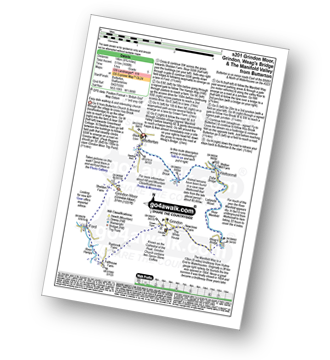
Vital Statistics:
| Length: | 4.75 miles (7.5 km) |
| Ascent: | 909ft (277m) |
| Time: | 3 hrs |
| Grade: |  |
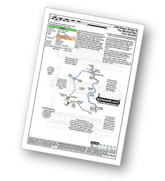
Route Summary:
Grindon - Weag's Bridge - The Manifold Way - Thor's Cave - Wettonmill - Hoo Brook - Grindon
|
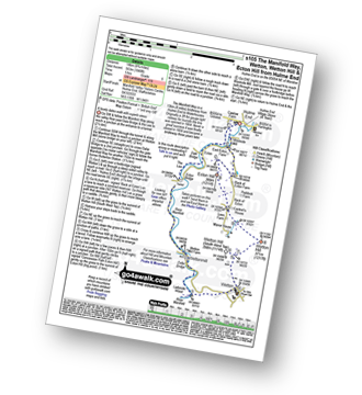
Vital Statistics:
| Length: | 6 miles (9.5 km) |
| Ascent: | 1,034ft (315m) |
| Time: | 3.25hrs |
| Grade: |  |
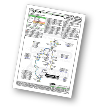
Route Summary:
Hulme End - Manifold Valley Visitors Centre - The Manifold Way - Dale Bridge - The Lee - Tunnel - River Manifold - Wetton Mill Farm - Wettonmill - Dale Farm - Sugarloaf (Wetton) - Broad Ecton Farm - Ecton Hill - Westside Mill - The Manifold Way - Hulme End
|
Vital Statistics:
| Length: | 4.5 miles (7 km) |
| Ascent: | 623ft (190m) |
| Time: | 2.25hrs |
| Grade: | |
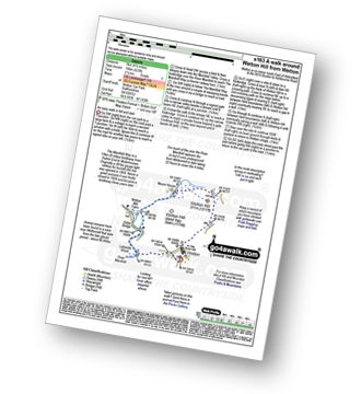
Route Summary:
Wetton - River Manifold - Wettonmill - The Manifold Way - Thor's Cave - Manor House - Wetton
|
Vital Statistics:
| Length: | 7 miles (10.5 km) |
| Ascent: | 787ft (240m) |
| Time: | 3.25hrs |
| Grade: |  |
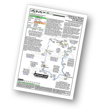
Route Summary:
Wettonmill - Hoo Brook - Butterton - Warslow - Dale Bridge - Ecton - The Manifold Way - The River Manifold - Manifold Valley - Wettonmill
|
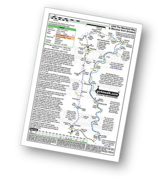
Vital Statistics:
| Length: | 8.75 miles (14 km) |
| Ascent: | 1,690ft (515m) |
| Time: | 5 hrs |
| Grade: |  |
Route Summary:
Butterton - Grindon Moor (Grindon Moor) - Ford - Ryebrook Farm - Grindon - Weag's Bridge - The Manifold Way - The River Manifold - Thor's Cave - Ladyside Wood - Dafar Bridge - Wettonmill - Hoo Brook - Butterton
|
Vital Statistics:
| Length: | 8.75 miles (14 km) |
| Ascent: | 1,848ft (563m) |
| Time: | 5 hrs |
| Grade: |  |
Route Summary:
Hulme End - Manifold Valley Visitors Centre - The Manifold Way - Dale Bridge - The Lee - Tunnel - River Manifold - Wetton Mill Farm - Wettonmill - Dafar Bridge - Ladyside Wood - Wetton - Wetton Hill (South West Top) - Wetton Hill - Cantrell's House - Ecton Hill - Westside Mill - The Manifold Way - Hulme End
|
Vital Statistics:
| Length: | 10.5 miles (17 km) |
| Ascent: | 1,847ft (563m) |
| Time: | 5.75hrs |
| Grade: | |
Route Summary:
Grindon - Weag's Bridge - The Manifold Way - The River Manifold - Thor's Cave - Dafar Bridge - Wettonmill - Ecton Bridge - Dale Bridge - Ecton - Hulme End - Hollow Farm - Warslow Hall - Upper Brownhill Farm - Warslow - Villa Farm - Clayton House - Wallacre - Hoo Brook - Ladyside Farm - Grindon
Find more fantastic easy-to-follow circular walks in The Peak District
To contribute to go4awalk.com or to contact us about anything at all - see Talk To Us. For help see Help.
go4awalk.com and go4awalk.co.uk are registered trademarks of TMDH Limited.
Copyright © 2000-2024 TMDH Limited. All rights reserved.
Copyright | Terms & Conditions | Privacy Statement
A - Z
Walks
Home
Log On/Accounts
Photo Gallery
Walk Ideas and Collections
Fell Facts
Places to Stay
Hill Skills
Walking Questions and Answers
Your Stories
News
Competitions
Product Reviews/Gear Tests
Walking Gear Guides
Peaks and Mountains
Peak Bagging
Find New Walking Friends
Camping
GPS Waypoints for Walking
Walk Search
Talk to us
go4awalk.com Help
Free example walks
Newsletter


