Walks Routes Maps from Friar Well in The Western Fells, The Lake District, Cumbria in Walk Grade Order
Route maps for Walks that start, or go through, Friar Well in The Western Fells, The Lake District, Cumbria, England in Walk Grade Order
Details of refreshments, pubs & parking are included on each Friar Well walk description.
   |
Vital Statistics:
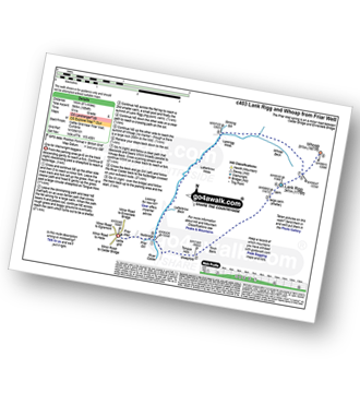
| Length: | 8.75 miles (14 km) |
| Ascent: | 1,854ft (565m) |
| Time: | 5 hrs |
| Grade: |  |
Route Summary:
Friar Well - Friar Gill - River Calder - Tongue How - Town Bank - Lank Rigg - Whoap - Whoap Beck - Stinking Gill - Lankrigg Moss - Latterbrow Moss - Latterbrow Beck - Friar Well
Find more fantastic easy-to-follow circular walks in The Lake District

To contribute to go4awalk.com or to contact us about anything at all - see Talk To Us. For help see Help.
go4awalk.com and go4awalk.co.uk are registered trademarks of TMDH Limited.
Copyright © 2000-2024 TMDH Limited. All rights reserved.
Copyright | Terms & Conditions | Privacy Statement
A - Z
Walks
Home
Log On/Accounts
Photo Gallery
Walk Ideas and Collections
Fell Facts
Places to Stay
Hill Skills
Walking Questions and Answers
Your Stories
News
Competitions
Product Reviews/Gear Tests
Walking Gear Guides
Peaks and Mountains
Peak Bagging
Find New Walking Friends
Camping
GPS Waypoints for Walking
Walk Search
Talk to us
go4awalk.com Help
Free example walks
Newsletter


