Walks Routes Maps from Glyntawe in The Brecon Beacons Area, The Brecon Beacons, Powys in Walk Grade Order
Route maps for Walks that start, or go through, Glyntawe in The Brecon Beacons Area, The Brecon Beacons, Powys, Wales in Walk Grade Order
Details of refreshments, pubs & parking are included on each Glyntawe walk description.
   |
Vital Statistics:
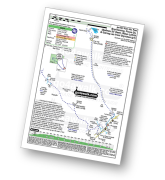
| Length: | 15 miles (24 km) |
| Ascent: | 3,673ft (1,119m) |
| Time: | 9.25hrs |
| Grade: |  |
Route Summary:
Glyntawe - Afon Tawe - Ty Hendrey - Allt Fach - Fan Fechan - Fan Hir - Bwlch Giedd - The Beacons Way - Fan Brycheiniog (Twr y Fan Foel) - Fan Foel - Tro'r Fan Foel - Bwlch Blaen Twrch - Pant y Bwlch - Picws Du (Bannau Sir Gaer) - Glastir y Picws - Cwar Du Mawr - Cwar Du Bach - Waun Lefrith (Bannau Sir Gaer) - Afon Mihartfach - Carreg yr Ogof - Garreg Las (Twyn Swnd) - Pen Rhiw-goch - Twrch Fechan - Cwterydd Blaen-Twrch Fechag - Esgair Ddu (Black Mountains) - Carnau Nant-Menyn - Nant Lluestau - Afon Twrch - Afon Giedd - Pwll y Cig - Waun Fignen Felen - Disgwylfa - Twynwalter - Twyn Spratt - Afon Haffes - Dan-yr-Ogog Campsite and Showcaves - Glyntawe
Find more fantastic easy-to-follow circular walks in The Brecon Beacons

To contribute to go4awalk.com or to contact us about anything at all - see Talk To Us. For help see Help.
go4awalk.com and go4awalk.co.uk are registered trademarks of TMDH Limited.
Copyright © 2000-2024 TMDH Limited. All rights reserved.
Copyright | Terms & Conditions | Privacy Statement
A - Z
Walks
Home
Log On/Accounts
Photo Gallery
Walk Ideas and Collections
Fell Facts
Places to Stay
Hill Skills
Walking Questions and Answers
Your Stories
News
Competitions
Product Reviews/Gear Tests
Walking Gear Guides
Peaks and Mountains
Peak Bagging
Find New Walking Friends
Camping
GPS Waypoints for Walking
Walk Search
Talk to us
go4awalk.com Help
Free example walks
Newsletter


