Walks Routes Maps from Nant Peris in The Glyders (or Glyderau), Snowdonia, Gwynedd in Walk Grade Order
Route maps for Walks that start, or go through, Nant Peris in The Glyders (or Glyderau), Snowdonia, Gwynedd, Wales in Walk Grade Order
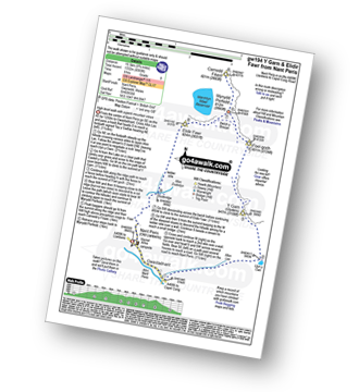
Details of refreshments, pubs & parking are included on each Nant Peris walk description.
   |
Vital Statistics:
| Length: | 10.75 miles (17 km) |
| Ascent: | 4,699ft (1,432m) |
| Time: | 8½ hrs |
| Grade: |  |
Route Summary:
Nant Peris - Gwastadnant - Afon Las - Llyn y Cwm - Y Garn (Glyderau) - Bwlch y Cywion - Foel-goch - Bwlch y Brecan - Mynydd Perfedd - Carnedd y Filiast (Glyderau) - Carnedd y Filiast (Glyderau) (North Top) - Carnedd y Filiast (Glyderau) - Mynydd Perfedd - Bwlch y Marchlyn - Elidir Fawr - Afon Dudodyn - Nant Peris
Find more fantastic easy-to-follow circular walks in Snowdonia

To contribute to go4awalk.com or to contact us about anything at all - see Talk To Us. For help see Help.
go4awalk.com and go4awalk.co.uk are registered trademarks of TMDH Limited.
Copyright © 2000-2024 TMDH Limited. All rights reserved.
Copyright | Terms & Conditions | Privacy Statement
A - Z
Walks
Home
Log On/Accounts
Photo Gallery
Walk Ideas and Collections
Fell Facts
Places to Stay
Hill Skills
Walking Questions and Answers
Your Stories
News
Competitions
Product Reviews/Gear Tests
Walking Gear Guides
Peaks and Mountains
Peak Bagging
Find New Walking Friends
Camping
GPS Waypoints for Walking
Walk Search
Talk to us
go4awalk.com Help
Free example walks
Newsletter


