The Yorkshire Three Peaks Challenge Walk - Ordnance Survey Map and Walk Route Guide


![]() STOP PRESS:
IMPORTANT: The Yorkshire Three Peaks route was changed during the winter of 2012 after a number of challengers ended up waist deep in boggy ground. Instead of crossing Todber Moss, Black Dubb Moss and Red Moss, it now goes south of Hull Pot to cross Whitber Hill, Sell Gill Beck, Sell Gill Hill, Jackdaw Hole and Penyghent Churn to rejoin the original route on High Pasture. Our definitive route guide has been amended to reflect this change - so don't risk attempting this walk without all the latest route information.
STOP PRESS:
IMPORTANT: The Yorkshire Three Peaks route was changed during the winter of 2012 after a number of challengers ended up waist deep in boggy ground. Instead of crossing Todber Moss, Black Dubb Moss and Red Moss, it now goes south of Hull Pot to cross Whitber Hill, Sell Gill Beck, Sell Gill Hill, Jackdaw Hole and Penyghent Churn to rejoin the original route on High Pasture. Our definitive route guide has been amended to reflect this change - so don't risk attempting this walk without all the latest route information.
![]() STOP PRESS:
GPS Waypoint Data in both GPX (.gpx) and Text (.txt) format now available for The Yorkshire Three Peaks Challenge Walk.
STOP PRESS:
GPS Waypoint Data in both GPX (.gpx) and Text (.txt) format now available for The Yorkshire Three Peaks Challenge Walk.
![]() STOP PRESS:
Our route guide now includes section timings (which take account of the fact that going up hill is slower than going down) so you will know whether or not you are on schedule to complete the walk within the required 12 hours. NB These timings have been adjusted to account for the new, slightly longer, version of the route established at the end of 2012.
STOP PRESS:
Our route guide now includes section timings (which take account of the fact that going up hill is slower than going down) so you will know whether or not you are on schedule to complete the walk within the required 12 hours. NB These timings have been adjusted to account for the new, slightly longer, version of the route established at the end of 2012.
![]() STOP PRESS:
We have been advised that the safety service run by the Pen-y-ghent Cafe has been temporarily suspended. The Clock Card service however is still available.
STOP PRESS:
We have been advised that the safety service run by the Pen-y-ghent Cafe has been temporarily suspended. The Clock Card service however is still available.
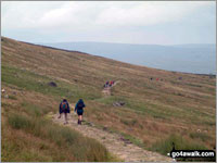 The long haul back to Horton in Ribblesdale from Ingleborough
Photo: David Hayter
The map you will need is Ordnance Survey 1:25000 series Explorer Map OL2 Yorkshire Dales - Southern & Western Area.
Important: The route of the Yorkshire Three Peaks Challenge Walk is not marked on the Ordnance Survey map, and it is not marked on the ground either, so every member of your party must either already know the way or carry a good detailed walk route guide. Our experience suggests that groups of Yorkshire Three Peaks Challengers tend to get strung out along the route as the leaders press on for a good finishing time and the slower members of the party start to tire.
The go4awalk.com Yorkshire Three Peaks Challenge Walk Route Guide includes full, easy to follow route instructions - complete with downloadable GPS Waypoints that you can upload direct to your GPS Device and split timings so you will know whether or not you are on schedule to complete the walk within the required 12 hours. Account holders can download it from this link - ny101 The Yorkshire Three Peaks.
With most books being several (or more) years out-of-date we believe our route guide for The Yorkshire Three Peaks Challenge walk is the clearest, most up-to-date route guide you can get. It is also probably the lightest one to carry - which might just be important as you approach the steep climb up Ingleborough at mile 18!
Besides, along with your footwear and your fitness levels, the success of your whole day will depend on the quality of the route guide you have with you - so download it now and don't leave it to chance!
Feedback from fellow challengers has suggested that the best approach is to download a copy of our route guide now (for planning and appetite whetting purposes) and then download a 2nd route guide just before you go. Since we regularly update all our route guides with user feedback this will ensure you are walking The Yorkshire Three Peaks Challenge Walk with all the very latest information.
As well as the Yorkshire Three Peaks Challenge Walk, an account with go4awalk.com offers access to all the other superb walks on this award winning site including all the best routes in The Lake District, The Peak District and Snowdonia as well as plenty of other superb walks in the Yorkshire Dales, The Brecon Beacons and beyond.
Finally, make sure you read Hill Skills > What to do in Emergencies for advice on what to do should you or one of your party get into difficulties.
Good Luck and enjoy it (you will).
Remember, this is supposed to be fun (it is).
Download and Print our easy to follow route map and directions for The Yorkshire Three Peaks Challenge Walk from Horton in Ribbleshead and walk it for yourself
To contribute to go4awalk.com or to contact us about anything at all - see Talk To Us. For help see Help.
go4awalk.com and go4awalk.co.uk are registered trademarks of TMDH Limited.
Copyright © 2000-2024 TMDH Limited. All rights reserved.
Copyright | Terms & Conditions | Privacy Statement
A - Z
Walks
Home
Log On/Accounts
Photo Gallery
Walk Ideas and Collections
Fell Facts
Places to Stay
Hill Skills
Walking Questions and Answers
Your Stories
News
Competitions
Product Reviews/Gear Tests
Walking Gear Guides
Peaks and Mountains
Peak Bagging
Find New Walking Friends
Camping
GPS Waypoints for Walking
Walk Search
Talk to us
go4awalk.com Help
Free example walks
Newsletter


