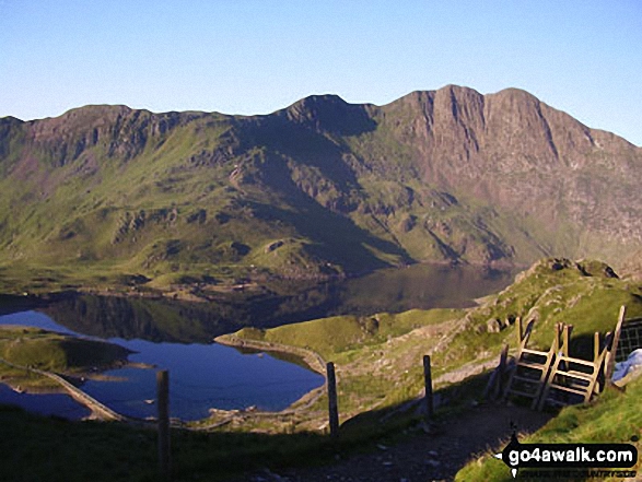
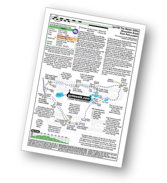
Llyn Llydaw with Y Lliwedd beyond from Bwlch y Moch
The Snowdon Area
Snowdonia National Park
Gwynedd, Wales

Walk Photo: Llyn Llydaw with Y Lliwedd beyond from Bwlch y Moch The Snowdon Area Snowdonia National Park Gwynedd Wales by Will Caesar (5)
Walk Photograph by:  

Will Caesar (5 of 31)

See Previous | Next | All

More photos of walks in Snowdonia National Park

More photos of walks in Gwynedd

To go back to the previous page - use your Back Button


To experience views like this - walk these walks:


Walk gw154 Llyn Llydaw and Glaslyn via the PYG Track and Miners’ Track from Pen y Pass

Snowdonia National Park The Snowdon Area Gwynedd North Wales

A taste of Snowdon without the climbing

Walk gw154 Llyn Llydaw and Glaslyn via the PYG Track and Miners’ Track from Pen y Pass Route Summary:

Pen y Pass, Pyg Track, Bwlch y Moch, Craig Fach, Glaslyn, Miners’ Track, Llyn Llydaw, Llyn Teyrn, Pen y Pass

Length: 8.50km (4.5 miles) | Ascent: 476m (1562ft) | Time: 3.50hrs | Grade: Walk Grades Explanation and Help

For more walks near walk gw154 Llyn Llydaw and Glaslyn via the PYG Track and Miners’ Track from Pen y Pass - see these interactive Ordnance Survey Maps:

 OS Explorer OL17 or  OS Landranger 115
Llyn Llydaw with Y Lliwedd beyond from Bwlch y Moch Photos from Walks in The Snowdon Area Snowdonia National Park Gwynedd Wales by Will Caesar (5) Llyn Llydaw with Y Lliwedd beyond from Bwlch y Moch Photos from Walks in The Snowdon Area Snowdonia National Park Gwynedd Wales by Will Caesar (5) Llyn Llydaw with Y Lliwedd beyond from Bwlch y Moch Photos from Walks in The Snowdon Area Snowdonia National Park Gwynedd Wales by Will Caesar (5)

or see walks displayed using Google Maps that start at the Same Location
or within 5 | 10 | 15 | 20 | 25 miles of this one.

or see a list of walks that start within 5 | 10 | 15 | 20 | 25 miles of this one.

See pictures of walk gw154 Llyn Llydaw and Glaslyn via the PYG Track and Miners’ Track from Pen y Pass   Get directions to the start of walk gw154 Llyn Llydaw and Glaslyn via the PYG Track and Miners’ Track from Pen y Pass using Google Maps  Find new walking groups and friends for walks in Snowdonia National Park

Walk gw154 Llyn Llydaw and Glaslyn via the PYG Track and Miners’ Track from Pen y Pass is currently available from a link in this month's go4walk.com Newsletter.


Walk gw153 Crib Goch from Pen y Pass
GPS Waypoint Data is included on walk gw153 Crib Goch from Pen y Pass map

Snowdonia National Park The Snowdon Area Gwynedd North Wales

Snowdon’s famous ridge walk

Walk gw153 Crib Goch from Pen y Pass Route Summary:

Pen y Pass, Pyg Track, Bwlch y Moch, Craig Fach, Crib Goch, Bwlch Cove, Pyg Track, Pen y Pass

Length: 9.50km (6 miles) | Ascent: 739m (2424ft) | Time: 4.50hrs | Grade: Walk Grades Explanation and Help

For more walks near walk gw153 Crib Goch from Pen y Pass - see these interactive Ordnance Survey Maps:

 OS Explorer OL17 or  OS Landranger 115
Llyn Llydaw with Y Lliwedd beyond from Bwlch y Moch Photos from Walks in The Snowdon Area Snowdonia National Park Gwynedd Wales by Will Caesar (5) Llyn Llydaw with Y Lliwedd beyond from Bwlch y Moch Photos from Walks in The Snowdon Area Snowdonia National Park Gwynedd Wales by Will Caesar (5) Llyn Llydaw with Y Lliwedd beyond from Bwlch y Moch Photos from Walks in The Snowdon Area Snowdonia National Park Gwynedd Wales by Will Caesar (5)

or see walks displayed using Google Maps that start at the Same Location
or within 5 | 10 | 15 | 20 | 25 miles of this one.

or see a list of walks that start within 5 | 10 | 15 | 20 | 25 miles of this one.

See pictures of walk gw153 Crib Goch from Pen y Pass   Get directions to the start of walk gw153 Crib Goch from Pen y Pass using Google Maps  Find new walking groups and friends for walks in Snowdonia National Park


Walk gw134 Mount Snowdon (Yr Wyddfa) avoiding Crib Goch from Pen y Pass
GPS Waypoint Data is included on walk gw134 Mount Snowdon (Yr Wyddfa) avoiding Crib Goch from Pen y Pass map

Snowdonia National Park The Snowdon Area Gwynedd North Wales

The shortest way up Wales’ highest

Walk gw134 Mount Snowdon (Yr Wyddfa) avoiding Crib Goch from Pen y Pass Route Summary:

Pen y Pass, Pyg Track, Bwlch y Moch, Craig Fach, Miners’ Track, Snowdon, Miners’ Track, Glaslyn, Llyn Llydaw, Pen y Pass

Length: 12.00km (7.5 miles) | Ascent: 925m (3034ft) | Time: 6.00hrs | Grade: Walk Grades Explanation and Help

For more walks near walk gw134 Mount Snowdon (Yr Wyddfa) avoiding Crib Goch from Pen y Pass - see these interactive Ordnance Survey Maps:

 OS Explorer OL17 or  OS Landranger 115
Llyn Llydaw with Y Lliwedd beyond from Bwlch y Moch Photos from Walks in The Snowdon Area Snowdonia National Park Gwynedd Wales by Will Caesar (5) Llyn Llydaw with Y Lliwedd beyond from Bwlch y Moch Photos from Walks in The Snowdon Area Snowdonia National Park Gwynedd Wales by Will Caesar (5) Llyn Llydaw with Y Lliwedd beyond from Bwlch y Moch Photos from Walks in The Snowdon Area Snowdonia National Park Gwynedd Wales by Will Caesar (5)

or see walks displayed using Google Maps that start at the Same Location
or within 5 | 10 | 15 | 20 | 25 miles of this one.

or see a list of walks that start within 5 | 10 | 15 | 20 | 25 miles of this one.

See pictures of walk gw134 Mount Snowdon (Yr Wyddfa) avoiding Crib Goch from Pen y Pass   Get directions to the start of walk gw134 Mount Snowdon (Yr Wyddfa) avoiding Crib Goch from Pen y Pass using Google Maps  Find new walking groups and friends for walks in Snowdonia National Park


Walk gw198 The Welsh 3000’s (Snowdon Area) from Pen y Pass
GPS Waypoint Data is included on walk gw198 The Welsh 3000’s (Snowdon Area) from Pen y Pass map

Snowdonia National Park The Snowdon Area Gwynedd North Wales

A classic horseshoe walk

Walk gw198 The Welsh 3000’s (Snowdon Area) from Pen y Pass Route Summary:

Pen y Pass, Pyg Track, Bwlch y Moch, Craig Fach, Crib Goch, Garnedd Ugain (Crib y Ddysgl), Snowdon (Yr Wyddfa), Bwlch y Saethau, Y Lliwedd, Y Lliwedd (East Top), Miners’ Track, Pen y Pass

Length: 11.00km (7 miles) | Ascent: 1160m (3805ft) | Time: 6.25hrs | Grade: Walk Grades Explanation and Help

For more walks near walk gw198 The Welsh 3000’s (Snowdon Area) from Pen y Pass - see these interactive Ordnance Survey Maps:

 OS Explorer OL17 or  OS Landranger 115
Llyn Llydaw with Y Lliwedd beyond from Bwlch y Moch Photos from Walks in The Snowdon Area Snowdonia National Park Gwynedd Wales by Will Caesar (5) Llyn Llydaw with Y Lliwedd beyond from Bwlch y Moch Photos from Walks in The Snowdon Area Snowdonia National Park Gwynedd Wales by Will Caesar (5) Llyn Llydaw with Y Lliwedd beyond from Bwlch y Moch Photos from Walks in The Snowdon Area Snowdonia National Park Gwynedd Wales by Will Caesar (5)

or see walks displayed using Google Maps that start at the Same Location
or within 5 | 10 | 15 | 20 | 25 miles of this one.

or see a list of walks that start within 5 | 10 | 15 | 20 | 25 miles of this one.

See pictures of walk gw198 The Welsh 3000’s (Snowdon Area) from Pen y Pass   Get directions to the start of walk gw198 The Welsh 3000’s (Snowdon Area) from Pen y Pass using Google Maps  Find new walking groups and friends for walks in Snowdonia National Park


Walk gw100 Mount Snowdon (Yr Wyddfa) from Pen y Pass
GPS Waypoint Data is included on walk gw100 Mount Snowdon (Yr Wyddfa) from Pen y Pass map

Snowdonia National Park The Snowdon Area Gwynedd North Wales

The quickest way up Wales’ highest

Walk gw100 Mount Snowdon (Yr Wyddfa) from Pen y Pass Route Summary:

Pen y Pass, Pyg Track, Bwlch y Moch, Craig Fach, Miners’ Track, Snowdon, Miners’ Track, Pyg Track, Bwlch y Moch, Pen y Pass

Length: 10.50km (6.5 miles) | Ascent: 895m (2938ft) | Time: 5.50hrs | Grade: Walk Grades Explanation and Help

For more walks near walk gw100 Mount Snowdon (Yr Wyddfa) from Pen y Pass - see these interactive Ordnance Survey Maps:

 OS Explorer OL17 or  OS Landranger 115
Llyn Llydaw with Y Lliwedd beyond from Bwlch y Moch Photos from Walks in The Snowdon Area Snowdonia National Park Gwynedd Wales by Will Caesar (5) Llyn Llydaw with Y Lliwedd beyond from Bwlch y Moch Photos from Walks in The Snowdon Area Snowdonia National Park Gwynedd Wales by Will Caesar (5) Llyn Llydaw with Y Lliwedd beyond from Bwlch y Moch Photos from Walks in The Snowdon Area Snowdonia National Park Gwynedd Wales by Will Caesar (5)

or see walks displayed using Google Maps that start at the Same Location
or within 5 | 10 | 15 | 20 | 25 miles of this one.

or see a list of walks that start within 5 | 10 | 15 | 20 | 25 miles of this one.

See pictures of walk gw100 Mount Snowdon (Yr Wyddfa) from Pen y Pass   Get directions to the start of walk gw100 Mount Snowdon (Yr Wyddfa) from Pen y Pass using Google Maps  Find new walking groups and friends for walks in Snowdonia National Park


Walk gw136 The Snowdon (Yr Wyddfa) Horseshoe from Pen y Pass
GPS Waypoint Data is included on walk gw136 The Snowdon (Yr Wyddfa) Horseshoe from Pen y Pass map

Snowdonia National Park The Snowdon Area Gwynedd North Wales

A classic!

Walk gw136 The Snowdon (Yr Wyddfa) Horseshoe from Pen y Pass Route Summary:

Pen y Pass, Pyg Track, Bwlch y Moch, Craig Fach, Crib Goch, Garnedd Ugain (Crib y Ddysgl), Snowdon (Yr Wyddfa), Bwlch y Saethau, Y Lliwedd, Y Lliwedd (East Top), Gallt y Wenallt, Afon Glaslyn, Miners’ Track, Pen y Pass

Length: 12.00km (7.5 miles) | Ascent: 1250m (4100ft) | Time: 6.50hrs | Grade: Walk Grades Explanation and Help

For more walks near walk gw136 The Snowdon (Yr Wyddfa) Horseshoe from Pen y Pass - see these interactive Ordnance Survey Maps:

 OS Explorer OL17 or  OS Landranger 115
Llyn Llydaw with Y Lliwedd beyond from Bwlch y Moch Photos from Walks in The Snowdon Area Snowdonia National Park Gwynedd Wales by Will Caesar (5) Llyn Llydaw with Y Lliwedd beyond from Bwlch y Moch Photos from Walks in The Snowdon Area Snowdonia National Park Gwynedd Wales by Will Caesar (5) Llyn Llydaw with Y Lliwedd beyond from Bwlch y Moch Photos from Walks in The Snowdon Area Snowdonia National Park Gwynedd Wales by Will Caesar (5)

or see walks displayed using Google Maps that start at the Same Location
or within 5 | 10 | 15 | 20 | 25 miles of this one.

or see a list of walks that start within 5 | 10 | 15 | 20 | 25 miles of this one.

See pictures of walk gw136 The Snowdon (Yr Wyddfa) Horseshoe from Pen y Pass   Get directions to the start of walk gw136 The Snowdon (Yr Wyddfa) Horseshoe from Pen y Pass using Google Maps  Find new walking groups and friends for walks in Snowdonia National Park


Search Complete.

We will be adding more walks to this viewpoint very soon. Meanwhile, for some more great walk ideas you really must not miss see Walks.


If you would like to see your digital photographs as part of this collection, please send them as email attachments (configured for any computer) along with your name to and we shall do our best to publish them.

(Guide Resolution = 300dpi. At least = 400pixels (wide) x 300 pixels (high).)

NB. Please indicate where each photo was taken.


To contribute to go4awalk.com or to contact us about anything at all
- see Talk To Us. For help see Help.

NB. To see our navigational hills you must have the Macromedia Shockwave/Flash Player plug-in installed in your browser. This is free and comes as standard with later versions. If you have an early version browser - click here and follow Macromedia's installation instructions.

go4awalk.com and go4awalk.co.uk are registered trademarks of TMDH Limited.
Copyright © 2000-2010 TMDH Limited. All rights reserved.

Copyright | Terms & Conditions | Privacy Statement

A - Z   Walks   Home   Log On / Accounts   Photo Gallery
Walk Ideas and Collections   Fell Facts   Places to Stay   Hill Skills
Walking Questions and Answers   Your Stories   News   Competitions
Product Reviews/Gear Tests   Walking Gear Guides   Contents
Peaks and Mountains   Peak Bagging   Find New Walking Friends
Ordnance Survey Walking Maps   Camping   GPS Waypoints for Walking
Walk Search   Talk to us   go4awalk.com Help   Free example walks

Content on this page requires a newer version of Adobe Flash Player.

Get Adobe Flash player