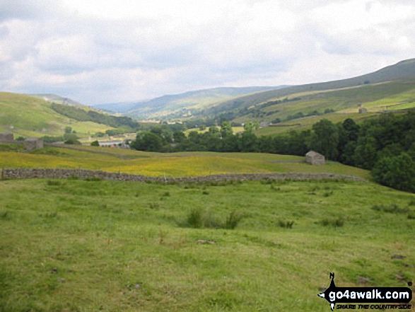
Walking and Hiking Photo:
Muker from The Pennine Way on Great Shunner Fell
The Northern Dales Area,
The Yorkshire Dales National Park,
North Yorkshire, England
The Northern Dales Area,
The Yorkshire Dales National Park,
North Yorkshire, England
   |
Vital Statistics:
| Length: | 13.75 miles (22 km) |
| Ascent: | 2,330ft (710m) |
| Time: | 7.25hrs |
| Grade: |  |
Route Summary:
Hawes - The Pennine Way - The Herriot Way - Haylands Bridge - The River Ure - Hardraw - Hardraw Force - Hearne Coal Road - Hollin Hill - Bluebell Hill - Blea Pot Plain - Hearn Top - Bleak Haw - Hearne Head - Great Shunner Fell - Little Shunner Fell - Pickersett Mea - Fossdale Moss - Grimy Gutter - Lovely Seat - Coal Gill Hags - Abbotside Common - High Clint - High Pasture Gate - Shutt Lane - Sedbusk - Hawes
Send us your photographs and pictures of walks and hikes in the British countryside
If you would like to see your digital photographs as part of this collection, please send them as email attachments (configured for any computer) along with your name to:
and we shall do our best to publish them.
(Guide Resolution = 300dpi. At least = 587 pixels (wide) x 440 pixels (high).)

You can also submit photos via our Facebook Page.
NB. Please indicate where each photo was taken.
NB. To see photographs and pictures from a particular walk choose your walk from Walks or use our Walk Search facility.
To see photographs and pictures on, of or from a particular Mountain, Peak, Top or Hill select from Peaks & Mountains' or enter the Mountain, Peak, Top or Hill Name into our 'Photo Search facility.

To contribute to go4awalk.com or to contact us about anything at all - see Talk To Us. For help see Help.
go4awalk.com and go4awalk.co.uk are registered trademarks of TMDH Limited.
Copyright © 2000-2024 TMDH Limited. All rights reserved.
Copyright | Terms & Conditions | Privacy Statement
A - Z
Walks
Home
Log On/Accounts
Photo Gallery
Walk Ideas and Collections
Fell Facts
Places to Stay
Hill Skills
Walking Questions and Answers
Your Stories
News
Competitions
Product Reviews/Gear Tests
Walking Gear Guides
Peaks and Mountains
Peak Bagging
Find New Walking Friends
Camping
GPS Waypoints for Walking
Walk Search
Talk to us
go4awalk.com Help
Free example walks
Newsletter


