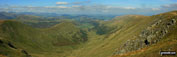
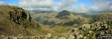
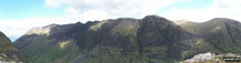
Photographs and Pictures from go4awalk.com Walks submitted by your fellow go4awalkers during September, 2009

To find a walk route* to the locations featured in these pictures, click the thumbnail. The most recent pictures are on the first page.


Page 1 of 2    Go to page: 1 2
spacer spacer spacer spacer spacer spacer spacer
Neuadd Reservoir  The Brecon Beacons National Park Powys Wales Weir on The River Wye near Rowsley  The Peak District National Park Derbyshire England Lock 15 on The Caldon Canal near Cheddleton   Staffordshire England Leigh Well The North Downs  Surrey England Leigh Church The North Downs  Surrey England Betchworth Church The North Downs  Surrey England Musical bench in Betchworth Churchyard The North Downs  Surrey England
Entrance gate to Betchworth Churchyard The North Downs  Surrey England Redhill to Tonbridge Main Railway Line where it passes under the M23, South Nutfield The North Downs  Surrey England Henhaw Farm, South Nutfield The North Downs  Surrey England Bletchingley village The North Downs  Surrey England Brewerstreet Farmhouse, Bletchingley The North Downs  Surrey England Godstone Green The North Downs  Surrey England Lake at Friday Street The North Downs  Surrey England
Waterfall near Stable Copse The North Downs  Surrey England Tower on the summit of Leith Hill   Surrey England Sculpture on the summit of Leith Hill The North Downs  Surrey England Friday Street The North Downs  Surrey England Leigh Place Pond near Godstone The North Downs  Surrey England Church Town Church The North Downs  Surrey England Bridge at Glebe Water near Godstone The North Downs  Surrey England
Leigh Place Pond near Godstone The North Downs  Surrey England The Caldon Canal from Basford Bridge, Cheddleton   Staffordshire England Bridge on The Caldon Canal near Cheddleton   Staffordshire England The Caldon Canal near Cheddleton   Staffordshire England Swing Bridge on The Caldon Canal   Staffordshire England  Lock 16 on The Caldon Canal   Staffordshire England Bridge at Lock 16 on The Caldon Canal   Staffordshire England
Distance marker on the towpath of The Caldon Canal   Staffordshire England The Caldon Canal   Staffordshire England The Caldon Canal in the Churnet Valley   Staffordshire England Old Lime Kilns at Consall Forge   Staffordshire England River Churnet Weir at Consall Forge   Staffordshire England Old Lime Kilns and The Caldon Canal at Consall Forge   Staffordshire England The Caldon Canal at Consall Forge   Staffordshire England
Bottom of the steps down to Consall Forge from Consall   Staffordshire England Top of the steps down to Consall Forge   Staffordshire England Steyning village  The South Downs National Park West Sussex England The South Downs Way marker post on Steyning Round Hill  The South Downs National Park West Sussex England Hay Bale Stack on The South Downs Way where it crosses Steyning Round Hill  The South Downs National Park West Sussex England Me at Steyning Round Hill Trig Point  The South Downs National Park West Sussex England View from Dare Valley Country Park near Aberdare   Rhondda Cynon Taff Wales
View from Dare Valley Country Park near Aberdare   Rhondda Cynon Taff Wales View from Dare Valley Country Park near Aberdare   Rhondda Cynon Taff Wales View from Dare Valley Country Park near Aberdare   Rhondda Cynon Taff Wales View from Dare Valley Country Park near Aberdare   Rhondda Cynon Taff Wales The Langdale Pikes from the summit of Wetherlam  The Lake District National Park Cumbria England Wetherlam from Swirl Hawse  The Lake District National Park Cumbria England Plane Wreck Memorial on the summit of Great Carrs  The Lake District National Park Cumbria England
Wet Side Edge and Greenburn from Swirl How  The Lake District National Park Cumbria England Sheep on Swirl How  The Lake District National Park Cumbria England Greenburn and Wetherlam from Swirl How  The Lake District National Park Cumbria England Wetherlam from Swirl How  The Lake District National Park Cumbria England Little Carrs from Hell Gill Pike, Wet Side Edge  The Lake District National Park Cumbria England Wet Side Edge and Greenburn Reservoir from the summit of Great Carrs  The Lake District National Park Cumbria England Cold Pike (left) and Pike of Blisco (Pike o' Blisco) from the summit of Great Carrs  The Lake District National Park Cumbria England
Great Carrs from Little Carrs  The Lake District National Park Cumbria England Cold Pike from the summit of Little Carrs  The Lake District National Park Cumbria England Black Sails and The Furness Fells from the summit of Swirl How  The Lake District National Park Cumbria England Coniston Water from the summit of Great Carrs  The Lake District National Park Cumbria England Fell Foot Bridge, Little Langdale  The Lake District National Park Cumbria England Castle Howe with Pike of Blisco (Pike o' Blisco) beyond from near Slater Bridge Bridge, Little Langdale  The Lake District National Park Cumbria England Busk Pike and The Langdale Pikes beyond Little Langdale Tarn from near Slater Bridge Bridge, Little Langdale  The Lake District National Park Cumbria England
Knott Head above Little Langdale Tarn from near Slater Bridge Bridge, Little Langdale  The Lake District National Park Cumbria England Little Langdale Tarn with sunlight on The Langdale Pikes beyond from near Slater Bridge Bridge, Little Langdale  The Lake District National Park Cumbria England River South Tyne at Alston  The Northumberland National Park Northumberland England Langley Castle  The Northumberland National Park Northumberland England Looking over Gilderdale Bridge  The Northumberland National Park Northumberland England View from Black Hill (Whitley Common)  The Northumberland National Park Northumberland England View north from Black Hill (Whitley Common)  The Northumberland National Park Northumberland England
Whitley Castle Roman Fort  The Northumberland National Park Northumberland England Carey Burn near Broom Crook Plantation  The Northumberland National Park Northumberland England View north from Old Middleton  The Northumberland National Park Northumberland England Watch Hill and Hart Heugh from the path above Carey Burn Bridge  The Northumberland National Park Northumberland England View from the path above Carey Burn Bridge  The Northumberland National Park Northumberland England View west from Carey Burn Bridge  The Northumberland National Park Northumberland England Mardale Head and Haweswater Reservoir from Rowantreethwaite Beck  The Lake District National Park Cumbria England
Speaking Crag across Haweswater Reservoir from Rowantreethwaite Beck  The Lake District National Park Cumbria England Overlooking the ruins of Riggindale Farm with Haweswater Reservoir beyond from the lower slopes of Rough Crag (Riggindale)  The Lake District National Park Cumbria England Rest Dodd (far left), The Nab (left), The Ramps Gill Valley, Wether Hill (right), Keasgill Head, Red Crag, Raven Howe and High Raise (Mardale) from Rampsgill Head  The Lake District National Park Cumbria England A break in the wall offers this view down towards Hartsop from the Straits of Riggindale  The Lake District National Park Cumbria England Rough Crag beyond Blea Water from  above Blea Water Crag between High Street and Mardale Ill Bell  The Lake District National Park Cumbria England The Scafell Massif featuring Scafell Pike (centre) and Sca Fell (centre left) from Swirl Band between Swirl How and Levers Hawse  The Lake District National Park Cumbria England Looking down Styhead Gill from Sty Head to a sunlit Borrowdale  with Bleaberry Fell the high point in the distance  The Lake District National Park Cumbria England
Looking down Greta Gill to Wasdale from Great End with Red Pike (Wasdale), Little Scoat Fell, Kirk Fell and Great Gable beyond  The Lake District National Park Cumbria England Lingmell Crag from across Piers Gill  The Lake District National Park Cumbria England A grand view overlooking the valley of upper Wasdale from Esk Hause with Pillar, Kirk Fell, Great Gable and Green Gable taking centre stage  The Lake District National Park Cumbria England An impressive looking Great Gable from near the summit of Broad Crag  The Lake District National Park Cumbria England A moody looking Great Gable from Great End's north ridge close to Custs Gully  The Lake District National Park Cumbria England Cribyn and Craig Cwm Sere from Pen y Fan  The Brecon Beacons National Park Powys Wales Esgeiriau Gwynion summit cairn with the Aran Fawddwy ridge in the distance  Snowdonia National Park Gwynedd Wales
Pen y Garn (Bryn Garw) summit trig point and shelter The Cambrian Mountains  Ceredigion Wales The Arch The Cambrian Mountains  Ceredigion Wales Descending back to Capel-y-ffin from Blacksmith's Anvil  The Brecon Beacons National Park Powys Wales Darren Lwyd from Blacksmith's Anvil  The Brecon Beacons National Park Powys Wales Chwarel y Fan summit cairn  The Brecon Beacons National Park Powys Wales Twyn Talycefn summit cairn  The Brecon Beacons National Park Powys Wales Rhos Dirion summit trig point  The Brecon Beacons National Park Powys Wales
Twmpa (Lord Hereford's Knob) summit cairn  The Brecon Beacons National Park Powys Wales Twmpa (Lord Hereford's Knob) and Gospel Pass from Hay Bluff  The Brecon Beacons National Park Powys Wales Hay Bluff summit trig point  The Brecon Beacons National Park Powys Wales Black Mountain summit cairn  The Brecon Beacons National Park Powys Wales Black Mountain (South Top) summit cairn  The Brecon Beacons National Park Powys Wales The Vale of Ewyas from The Offa's Dyke Path on Black Mountain (South Top)  The Brecon Beacons National Park Powys Wales Capel-y-ffin Chapel  The Brecon Beacons National Park Powys Wales
Brecon Mountain Railway Steam Engine  The Brecon Beacons National Park Powys Wales Pontsticill Reservoir  The Brecon Beacons National Park Powys Wales Cefn yr Ystrad summit trig point  The Brecon Beacons National Park Powys Wales Old Quarry sign on the lower slopes of Cefn yr Ystrad  The Brecon Beacons National Park Powys Wales Railway Bridge spanning the path up Cefn yr Ystrad from Pontsticill Reservoir  The Brecon Beacons National Park Powys Wales Yr Allt (Forest Fawr) summit cairn  The Brecon Beacons National Park Powys Wales Heol Senni (Fan Bwlch Chwyth) summit trig point  The Brecon Beacons National Park Powys Wales

*where available


Page 1 of 2    Go to page: 1 2

Send us your photographs and pictures of walks and hikes in the British countryside

If you would like to see your digital photographs as part of this collection, please send them as email attachments (configured for any computer) along with your name to:


and we shall do our best to publish them.

(Guide Resolution = 300dpi. At least = 400pixels (wide) x 300 pixels (high).)

Send us your walking and hiking photographs and pictures via Facebook

You can also submit photos via our Facebook Page.

NB. Please indicate where each photo was taken.

NB. To see photographs and pictures from a particular walk choose your walk from Walks or use our Walk Search facility.

To see photographs and pictures on, of or from a particular Mountain, Peak, Top or Hill select from Peaks & Mountains' or enter the Mountain, Peak, Top or Hill Name into our 'Photo Search facility.


Bookmark/Share this page with:

Photographs and Pictures from go4awalk.com Walks submitted by your fellow go4awalkers during September,  2009Delecious | Photographs and Pictures from go4awalk.com Walks submitted by your fellow go4awalkers during September,  2009Digg | Photographs and Pictures from go4awalk.com Walks submitted by your fellow go4awalkers during September,  2009Facebook | Photographs and Pictures from go4awalk.com Walks submitted by your fellow go4awalkers during September,  2009reddit | Photographs and Pictures from go4awalk.com Walks submitted by your fellow go4awalkers during September,  2009StumbleUpon | Photographs and Pictures from go4awalk.com Walks submitted by your fellow go4awalkers during September,  2009Twitter

Log On/Off

Follow go4awalk.com on Twitter Follow go4awalk.com on Facebook


Win Ultrathon Insect Repellent worth £125 competition


Home


Find new Friends to go walking with
Walk all 214 Wainwrights in just 59 Walks. Download GPS Waypoints - Great Walks you must not miss!
Walk The Yorkshire Three Peaks Challenge Walk - All the Latest Route Information, GPS Waypoints and Split Times to keep you on Schedule
Walk The British Three Peaks Challenge Walk - All the Latest Route Information and GPS Waypoints
See our pick of The Best Walks in The Lake District - Great Walks you must not miss!
Walk our pick of the Best Lake District Ridge Walks - Great Walks you must not miss!
Walk our pick of the Best Lake District Walks to do in the rain - Great Walks you must not miss!
Walk our pick of The Best Walks in Snowdonia - Great Walks you must not miss!
Walk our pick of The Best Ridge Walks in Wales - Walks you must not miss!
Walk our pick of The Best Walks in The Brecon Beacons - Great Walks you must not miss!
Walk our pick of The Best Walks in The Yorkshire Dales - Walks you must not miss!
Walk our pick of The Best Walks in The Peak District - Walks you must not miss!
Walk our pick of The Best Walks in The Forest of Bowland - Walks you must not miss!
Walk our pick of The Best Walks in Shropshire - Walks you must not miss!
Walk our pick of The Best Walks in Cheshire - Walks you must not miss!
Walk our pick of The Best Walks in Lancashire - Walks you must not miss!
Not sure where to walk next? Try Peak Bagging - Great Walks you must not miss!
Not sure where to walk next? Walk part of a National Trail - Great Walks you must not miss!
Walks with Downloadable and Uploadable GPS Waypoint Data
GET 10% OFF Ordnance Survey Maps with FREE postage and packing

Walking Kit Gear Tested by Walkers

Walking Gear Tested by Walkers
Full Site Search