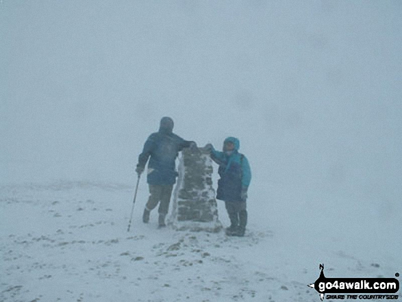
Walking and Hiking Photo:
A very snowy Helvellyn in early March!
The Eastern Fells,
The Lake District National Park,
Cumbria, England
The Eastern Fells,
The Lake District National Park,
Cumbria, England
Peter Dodds (1 of 1)
Previous
|
Next
|
   |
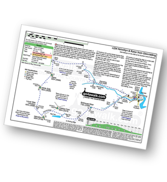
Vital Statistics:
| Length: | 10 miles (16 km) |
| Ascent: | 492ft (150m) |
| Time: | 4 hrs |
| Grade: |  |
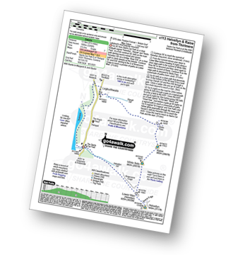
Route Summary:
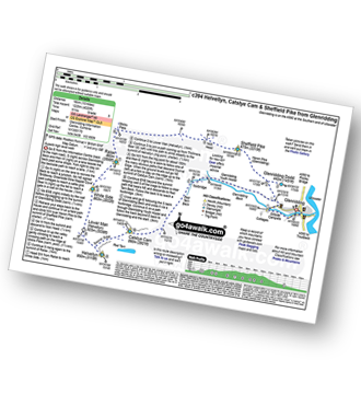
The Swirls Car Park - Thirlmere - Dalehead Hall - Thirlspot - Valve Houses - Beech Grove - Armboth - Hause Point - Dobgill Bridge - Wythburn - Stockhow Bridge - Wyth Burn - Helvellyn Screes - Highpark Wood - The Swirls Car Park - Thirlmere
|
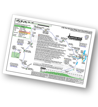
Vital Statistics:
| Length: | 8 miles (12.5 km) |
| Ascent: | 2,990ft (911m) |
| Time: | 6 hrs |
| Grade: |  |
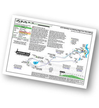
Route Summary:
Patterdale - Patterdale Church - Grisedale Bridge - Grisedale Beck - Brownend Plantation - Lanty's Tarn - Hole-in-the-Wall - Red Tarn (Helvellyn) - Bleaberry Crag - Low Spying How - High Spying How - Striding Edge - Helvellyn - Swirral Edge (optional) - Hole-in-the-Wall - Grisedale Beck - Patterdale
|
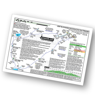
Vital Statistics:
| Length: | 5 miles (8 km) |
| Ascent: | 2,649ft (807m) |
| Time: | 4½ hrs |
| Grade: | |
Route Summary:
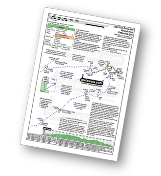
The Swirls - Helvellyn Gill - Browncove Crags - Lower Man (Helvellyn) - Helvellyn - Lower Man (Helvellyn) - Browncove Crags - Helvellyn Gill - The Swirls
|
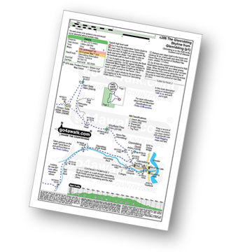
Vital Statistics:
| Length: | 8.75 miles (14 km) |
| Ascent: | 3,296ft (1,005m) |
| Time: | 6½ hrs |
| Grade: |  |
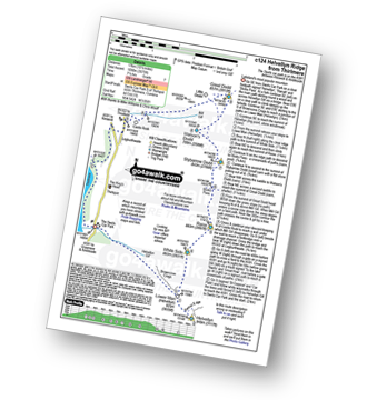
Route Summary:
The Swirls Car Park Thirlmere - Browncove Crags - Lower Man (Helvellyn) - Helvellyn - White Side - Raise (Helvellyn) - Sticks Pass - Sticks Gill - Stanah Gill - Legburthwaite - Thirlmere - Thirlspot - The Swirls Car Park Thirlmere.
|
Vital Statistics:
| Length: | 10.5 miles (17 km) |
| Ascent: | 3,575ft (1,090m) |
| Time: | 7½ hrs |
| Grade: | |
Route Summary:
The Swirls Car Park Thirlmere - Browncove Crags - Lower Man (Helvellyn) - Helvellyn - White Side - Raise (Helvellyn) - Sticks Pass - Stybarrow Dodd - Watson's Dodd - Great Dodd - Legburthwaite - Thirlmere - Thirlspot - The Swirls Car Park Thirlmere.
|
Vital Statistics:
| Length: | 8.5 miles (13.5 km) |
| Ascent: | 3,278ft (999m) |
| Time: | 6½ hrs |
| Grade: | |
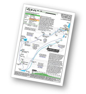
Route Summary:
Glenridding - Birkhouse Moor - Hole-in-the-Wall - Red Tarn (Helvellyn) - Bleaberry Crag - Low Spying How - High Spying How - Striding Edge - Helvellyn - Swirral Edge - Catstye Cam - Hole-in-the-Wall - Brownend Plantation - Grisedale Beck - Lanty's Tarn - Keldas - Glenridding
|
Vital Statistics:
| Length: | 10 miles (16 km) |
| Ascent: | 3,382ft (1,031m) |
| Time: | 7 hrs |
| Grade: | |
Route Summary:
Glenridding - Birkhouse Moor - Hole-in-the-Wall - Red Tarn (Helvellyn) - Bleaberry Crag - Low Spying How - High Spying How - Striding Edge - Helvellyn - Nethermost Pike - High Crag (Helvellyn) - Dollywaggon Pike - Grisdale Tarn - Ruthwaite Lodge - Grisedale Beck - Brownend Plantation - Lanty's Tarn - Keldas - Glenridding
|
Vital Statistics:
| Length: | 10.75 miles (17 km) |
| Ascent: | 3,449ft (1,051m) |
| Time: | 7.25hrs |
| Grade: | |
Route Summary:
Glenridding - Birkhouse Moor - Hole-in-the-Wall - Red Tarn (Helvellyn) - Catstye Cam - Swirral Edge - Helvellyn - Lower Man (Helvellyn) - White Side - Raise (Helvellyn) - Sticks Pass - Lucy's Tongue - Glenridding Beck - Glenridding
|
Vital Statistics:
| Length: | 13 miles (21 km) |
| Ascent: | 4,359ft (1,329m) |
| Time: | 9.25hrs |
| Grade: |  |
Route Summary:
Glenridding - Glenridding Dodd - Sheffield Pike - Green Side - Stybarrow Dodd - Sticks Pass - Raise (Helvellyn) - White Side - Lower Man (Helvellyn) - Helvellyn - Nethermost Pike - High Crag (Helvellyn) - Dollywaggon Pike - Grisdale Tarn - Grisedale Beck - Brownend Plantation - Lanty's Tarn - Keldas - Glenridding
|
Vital Statistics:
| Length: | 11.5 miles (18.5 km) |
| Ascent: | 4,582ft (1,396m) |
| Time: | 8.75hrs |
| Grade: | |
Route Summary:
Patterdale - Grisedale Bridge - Grisedale Beck - Brownends Plantation - Hole-in-the-Wall - Birkhouse Moor - Hole-in-the-Wall - Red Tarn (Helvellyn) - Bleaberry Crag - Low Spying How - High Spying How - Striding Edge - Helvellyn - Nethermost Pike - High Crag (Helvellyn) - Dollywaggon Pike - Grisedale Tarn - Deepdale Hause - St Sunday Crag - Birks - Patterdale
|
Vital Statistics:
| Length: | 11.5 miles (18.5 km) |
| Ascent: | 4,418ft (1,346m) |
| Time: | 8½ hrs |
| Grade: | |
Route Summary:
Glenridding - Glenridding Dodd - Sheffield Pike - Nick Head - Glencoyne Head - Hart Side - Green Side (White Stones) - Stybarrow Dodd - Sticks Pass - Raise (Helvellyn) - White Side - Lower Man (Helvellyn) - Helvellyn - Swirral Edge - Catstye Cam - Red Tarn Beck - Glenridding Beck - Glenridding Youth Hostel - Glenridding
|
Vital Statistics:
| Length: | 10 miles (16 km) |
| Ascent: | 4,020ft (1,225m) |
| Time: | 8 hrs |
| Grade: | |
Route Summary:
Glenridding - Glenridding Dodd - Sheffield Pike - Nick Head - Sticks Pass - Raise (Helvellyn) - White Side - Lower Man (Helvellyn) - Helvellyn - Swirral Edge - Catstye Cam - Glenridding Beck - Glenridding Youth Hostel - Glenridding
|
Vital Statistics:
| Length: | 13.25 miles (21 km) |
| Ascent: | 5,189ft (1,581m) |
| Time: | 10 hrs |
| Grade: |  |
Route Summary:
Patterdale - Grisedale Bridge - Grisedale Beck - Brownend Plantation - Hole-in-the-Wall - Birkhouse Moor - Hole-in-the-Wall - Red Tarn (Helvellyn) - Bleaberry Crag - Low Spying How - High Spying How - Striding Edge - Helvellyn - Nethermost Pike - High Crag (Helvellyn) - Dollywaggon Pike - Seat Sandal - Grisedale Tarn - St Sunday Crag - Birks - Arnison Crag - Patterdale
Send us your photographs and pictures of walks and hikes in the British countryside
If you would like to see your digital photographs as part of this collection, please send them as email attachments (configured for any computer) along with your name to:
and we shall do our best to publish them.
(Guide Resolution = 300dpi. At least = 587 pixels (wide) x 440 pixels (high).)

You can also submit photos via our Facebook Page.
NB. Please indicate where each photo was taken.
NB. To see photographs and pictures from a particular walk choose your walk from Walks or use our Walk Search facility.
To see photographs and pictures on, of or from a particular Mountain, Peak, Top or Hill select from Peaks & Mountains' or enter the Mountain, Peak, Top or Hill Name into our 'Photo Search facility.

To contribute to go4awalk.com or to contact us about anything at all - see Talk To Us. For help see Help.
go4awalk.com and go4awalk.co.uk are registered trademarks of TMDH Limited.
Copyright © 2000-2024 TMDH Limited. All rights reserved.
Copyright | Terms & Conditions | Privacy Statement
A - Z
Walks
Home
Log On/Accounts
Photo Gallery
Walk Ideas and Collections
Fell Facts
Places to Stay
Hill Skills
Walking Questions and Answers
Your Stories
News
Competitions
Product Reviews/Gear Tests
Walking Gear Guides
Peaks and Mountains
Peak Bagging
Find New Walking Friends
Camping
GPS Waypoints for Walking
Walk Search
Talk to us
go4awalk.com Help
Free example walks
Newsletter


