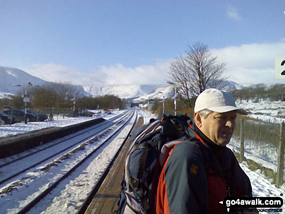
Walking and Hiking Photo:
Mike at Edale Station with Lord's Seat, Cowburn Tunnel and Brown Knoll in the background
The Peak District National Park,
Derbyshire, England
The Peak District National Park,
Derbyshire, England
   |
Vital Statistics:
| Length: | 3 miles (5 km) |
| Ascent: | 951ft (290m) |
| Time: | 2 hrs |
| Grade: |  |
Route Summary:
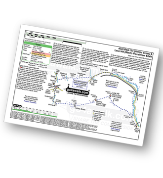
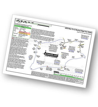
Edale - Small Clough - Hardenclough Farm - Greenlands - Mam Tor - Hollins Cross - Hollins - The Vale of Edale - Edale
|
Vital Statistics:
| Length: | 7 miles (11 km) |
| Ascent: | 1,044ft (318m) |
| Time: | 3½ hrs |
| Grade: |  |
Route Summary:
Edale - Ollerbrook Booth - Rowland Cote (Edale Youth Hostel) - Lady Brook Booth - Nether Moor - Backside Wood - Jaggers Clough - Edale End - Carr House - Nether Booth - Ollerbrook Booth - The Vale of Edale - Edale
|
Vital Statistics:
| Length: | 8.25 miles (13 km) |
| Ascent: | 1,812ft (552m) |
| Time: | 4.75hrs |
| Grade: |  |
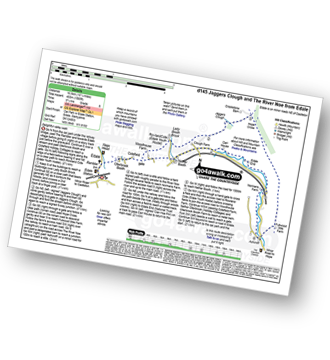
Route Summary:
Edale - The Nab - Ringing Roger - Edale Moor (Kinder Scout) - Madwoman's Stones - Crookstone Knoll (Kinder Scout) - Crookstone Hill - Hope Cross - Jaggers Clough - Backside Wood - Nether Moor - Lady Booth Brook - Rowland Cote (Edale Youth Hostel) - Ollerbrook Booth - The Vale of Edale - Edale
|
Vital Statistics:
| Length: | 8.25 miles (13 km) |
| Ascent: | 1,532ft (467m) |
| Time: | 4½ hrs |
| Grade: | |
Route Summary:
Edale - Small Clough - Hardenclough Farm - Greenlands - Hollins Cross - Back Tor (Hollins Cross) - Lose Hill (Ward's Piece) - Hope - The River Noe - Normans Farm - Edale End - Carr House - Nether Booth - Ollerbrook Booth - The Vale of Edale - Edale
|
Vital Statistics:
| Length: | 8.25 miles (13 km) |
| Ascent: | 1,860ft (567m) |
| Time: | 4.75hrs |
| Grade: | |
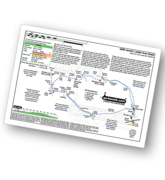
Route Summary:
Edale - The Pennine Way - Upper Booth - Jacob's Ladder (Edale) - Edale Head - Kinder Scout - Edale Moor - Kinder Plateau - Kinder Low (Kinder Scout) - Noe Stool (Edale Head) - Pym Chair (Edale Head) - Crowden Tower (Kinder Scout) - Crowden Brook - Grindslow Knoll (Kinder Scout) - Grindsbrook Clough - Grinds Brook - The Vale of Edale - Edale
|
Vital Statistics:
| Length: | 10.25 miles (16.5 km) |
| Ascent: | 1,585ft (483m) |
| Time: | 5.25hrs |
| Grade: |  |
Route Summary:
Edale - Ollerbrook Booth - Rowland Cote (Edale Youth Hostel) - Lady Booth Brook - Nether Moor - Backside Wood - Jaggers Clough - Hope Cross - Fulwood Stile Farm. Hope - The River Noe - Normans Farm - Edale End - Carr House - Nether Booth - Ollerbrook Booth - The Vale of Edale - Edale
|
Vital Statistics:
| Length: | 10.25 miles (16.5 km) |
| Ascent: | 1,870ft (570m) |
| Time: | 5.75hrs |
| Grade: | |
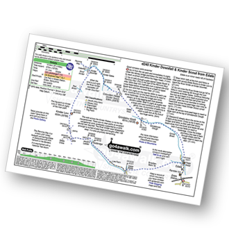
Route Summary:
Edale - The Pennine Way - Upper Booth - Jacob's Ladder (Edale) - Kinder Low (Kinder Scout) - Red Brook - Kinder Downfall - Kinder Scout - Edale Moor - Kinder Plateau - Crowden Head (Kinder Scout) - Grindslow Knoll (Kinder Scout) - Grindsbrook Clough - Grinds Brook - The Vale of Edale - Edale
|
Vital Statistics:
| Length: | 9.25 miles (15 km) |
| Ascent: | 1,919ft (585m) |
| Time: | 5.25hrs |
| Grade: | |
Route Summary:
Edale - Upper Booth - Highfield Farm - Tagsnaze Farm - The Orchard Farm - Dalehead Bunkhouse - Whitemoor Clough - Chapel Gate (Track) - Rushupp Edge - Lord's Seat (Rushup Edge) - Mam Tor - Hollins Cross - Backtor Nook - Backtor Farm - Backtor Bridge - Woodhouse Farm - The Vale of Edale - Cotefield Farm - Ollerbrook Booth - Edale
|
Vital Statistics:
| Length: | 10.5 miles (17 km) |
| Ascent: | 1,986ft (605m) |
| Time: | 5.75hrs |
| Grade: | |
Route Summary:
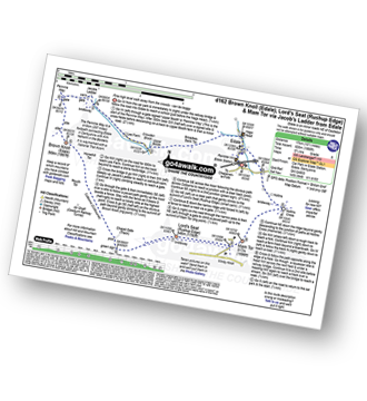
Edale - The Pennine Way - Upper Booth - Jacob's Ladder (Edale) - Brown Knoll (Edale) - Colborne (Colbourne) - Chapel Gate Track - Lord's Seat (Rushup Edge) - Mam Tor - Hollins Cross - Edale
Send us your photographs and pictures of walks and hikes in the British countryside
If you would like to see your digital photographs as part of this collection, please send them as email attachments (configured for any computer) along with your name to:
and we shall do our best to publish them.
(Guide Resolution = 300dpi. At least = 587 pixels (wide) x 440 pixels (high).)

You can also submit photos via our Facebook Page.
NB. Please indicate where each photo was taken.
NB. To see photographs and pictures from a particular walk choose your walk from Walks or use our Walk Search facility.
To see photographs and pictures on, of or from a particular Mountain, Peak, Top or Hill select from Peaks & Mountains' or enter the Mountain, Peak, Top or Hill Name into our 'Photo Search facility.
To contribute to go4awalk.com or to contact us about anything at all - see Talk To Us. For help see Help.
go4awalk.com and go4awalk.co.uk are registered trademarks of TMDH Limited.
Copyright © 2000-2024 TMDH Limited. All rights reserved.
Copyright | Terms & Conditions | Privacy Statement
A - Z
Walks
Home
Log On/Accounts
Photo Gallery
Walk Ideas and Collections
Fell Facts
Places to Stay
Hill Skills
Walking Questions and Answers
Your Stories
News
Competitions
Product Reviews/Gear Tests
Walking Gear Guides
Peaks and Mountains
Peak Bagging
Find New Walking Friends
Camping
GPS Waypoints for Walking
Walk Search
Talk to us
go4awalk.com Help
Free example walks
Newsletter


