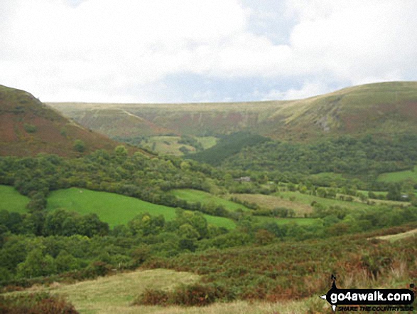
Hay Bluff, Black Mountain and The Offa’s Dyke path from Capel-y-ffin
The Brecon Beacons National Park
Powys Wales


Hay Bluff, Black Mountain and The Offa’s Dyke path from Capel-y-ffin walking  walks in The Brecon Beacons National Park Powys Wales

Walk Photograph by:  
Martin Mackey (3 of 4) See Previous | Next | All


To experience views like this - walk these walks:


1. Walk po148 Chwarel y Fan. Twmpa & Rhos Dirion from Capel-y-ffin
Download GPS Waypoint Data for walk po148 Chwarel y Fan. Twmpa & Rhos Dirion from Capel-y-ffin GPS Waypoint Data is included on walk po148 Chwarel y Fan. Twmpa & Rhos Dirion from Capel-y-ffin map
The Black Mountains Powys Wales

Download GPS Waypoint Data for walk po148 Chwarel y Fan. Twmpa & Rhos Dirion from Capel-y-ffin Download walk route map pdf for walk po148 Chwarel y Fan. Twmpa & Rhos Dirion from Capel-y-ffin
High moorland walk with fine views
Route Details: Capel-y-ffin, Chwarel y Fan, Blacksmith’s Anvil (stone) Twyn Talycefn, Rhos Dirion, Rhiw y Fan, Twmpa (Lord Hereford’s Knob), Darren Lwyd, Capel-y-ffin
Length: 16.50km (10.25ml) | Ascent: 638m (2093ft) | Time: 5.75hrs | Grade: Walk Grade
For more walks near this one - see these interactive maps:
 OS Explorer OL13
or
 OS Landranger 161
or see walks that start at the same location or within 5 | 10 | 15 | 20 | 25 miles displayed using Google Maps.
or see a list of walks that start within 5 | 10 | 15 | 20 | 25 miles.

See more photos from walk po148 Chwarel y Fan. Twmpa & Rhos Dirion from Capel-y-ffin


2. Walk po176 Hay Bluff & Twmpa from Capel-y-ffin
Download GPS Waypoint Data for walk po176 Hay Bluff & Twmpa from Capel-y-ffin GPS Waypoint Data is included on walk po176 Hay Bluff & Twmpa from Capel-y-ffin map
The Black Mountains Powys Wales

Download GPS Waypoint Data for walk po176 Hay Bluff & Twmpa from Capel-y-ffin Download walk route map pdf for walk po176 Hay Bluff & Twmpa from Capel-y-ffin
Superb views all round
Route Details: Capel-y-ffin, Offa’s Dyke Path, Black Mountain (South Top), Black Mountain, Hay Bluff, Gospel Pass, Twmpa (Lord Hereford’s Knob), Darren Lwyd, Capel-y-ffin
Length: 16.00km (10ml) | Ascent: 625m (2050ft) | Time: 5.50hrs | Grade: Walk Grade
For more walks near this one - see these interactive maps:
 OS Explorer OL13
or
 OS Landranger 161
or see walks that start at the same location or within 5 | 10 | 15 | 20 | 25 miles displayed using Google Maps.
or see a list of walks that start within 5 | 10 | 15 | 20 | 25 miles.

See more photos from walk po176 Hay Bluff & Twmpa from Capel-y-ffin


3. Walk po116 Black Mountain & Rhos Dirion
Download GPS Waypoint Data for walk po116 Black Mountain & Rhos Dirion GPS Waypoint Data is included on walk po116 Black Mountain & Rhos Dirion map
The Black Mountains Powys Wales

Download GPS Waypoint Data for walk po116 Black Mountain & Rhos Dirion Download walk route map pdf for walk po116 Black Mountain & Rhos Dirion
High moorland walk with superb views
Route Details: Capel-y-ffin, Offa’s Dyke path, Black Mountain (South Top), Black Mountain, Hay Bluff, Gospel Pass, Twmpa (Lord Hereford’s Knob), Rhiw y Fan, Rhos Dirion, Twyn Talycefn, Blacksmith’s Anvil, Chwarel y Fan, Capel-y-ffin
Length: 22.50km (14ml) | Ascent: 856m (2808ft) | Time: 8.00hrs | Grade: Walk Grade
For more walks near this one - see these interactive maps:
 OS Explorer OL13
or
 OS Landranger 161
or see walks that start at the same location or within 5 | 10 | 15 | 20 | 25 miles displayed using Google Maps.
or see a list of walks that start within 5 | 10 | 15 | 20 | 25 miles.

See more photos from walk po116 Black Mountain & Rhos Dirion


We are busy building the largest collection of walk related photographs available on the internet.


If you would like to see your photographs as part of this collection, send them as email attachments (configured for any computer) along with your name to the and we shall do our best to publish them.


Guide Size = at least 400pixels (wide) x 300 pixels (High)
Photos for moving panoramas must be at least 300pixels deep - we can create the side-to-side movement from static images - see example


NB. Please label each picture as clearly as possible including where each photograph was taken, which walk you were doing at the time and the view captured (if you know).


To contribute to go4awalk.com or to contact us about anything at all

- see Talk To Us. For help see Help.


NB. To see our navigational hills you must have the Macromedia Shockwave/Flash Player plug-in installed in your browser. This is free and comes as standard with later versions. If you have an early version browser - click here and follow Macromedia's installation instructions.


go4awalk.com and go4awalk.co.uk are registered trademarks of TMDH Limited.

Copyright © 2000-2008 TMDH Limited. All rights reserved.


Copyright | Terms & Conditions | Privacy Statement


Walks | Home | Log On / Accounts | Photo Gallery | Walk Ideas | Fell Facts | Places to Stay | Hill Skills | Walking Questions and Answers | Your Stories | News | Competitions | Gear Tests | Gear Guides | Gear Tips | Peaks and Mountains | Peak Bagging | Find New Walking Friends | Ordnance Survey Walking Maps | Camping | GPS Waypoints for Walking | Walk Search | go4awalk.com Help


Find a Friend to go walking with


Win fantastic walking gear with go4awalk.com
Christmas Gift Ideas for Walkers and Hikers 2008
Download GPS Waypoints
GET 10% OFF Ordnance Survey Maps with FREE postage and packing
Walking Gear Tested by Walkers

Dedicated hand-held GPS
Digital Mapping
Apple ipod
Apple iphone
Nokia GPS Phone
Garmin Nuvifone GPS Phone

None of the above