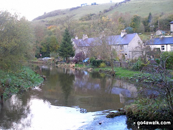
Walking and Hiking Photo:
The River Wye at Litton Mill
The Peak District National Park,
Derbyshire, England
The Peak District National Park,
Derbyshire, England
   |
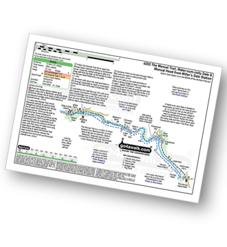
Vital Statistics:
| Length: | 6 miles (9.5 km) |
| Ascent: | 515ft (157m) |
| Time: | 2.75hrs |
| Grade: |  |
Route Summary:
Miller's Dale Station - The Monsal Trail - The River Wye - Miller's Dale - Water-cum-Jolly Dale - Cressbrook Mill - The River Wye - Water-cum-Jolly Dale - Litton Mill - Bellamy's Bank - Miller's Dale Station
|
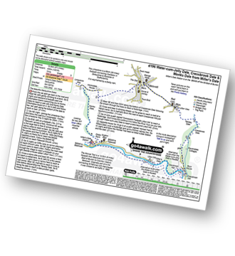
Vital Statistics:
| Length: | 6 miles (9.5 km) |
| Ascent: | 532ft (162m) |
| Time: | 2.75hrs |
| Grade: | |
Route Summary:
Monsal Head - Upperdale - The River Wye - Cressbrook Mill - The River Wye - Water-cum-Jolly Dale - Litton Mill - The Monsal Trail - Water-cum-Jolly Dale - Monsal Head Viaduct - Monsal Head
|
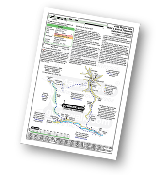
Vital Statistics:
| Length: | 6.5 miles (10.5 km) |
| Ascent: | 1,063ft (324m) |
| Time: | 3½ hrs |
| Grade: |  |
Route Summary:
Tideswell - Litton - Tansley Dale - Cressbrook Dale - Cressbrook - The Monsal Trail - Water-cum-Jolly Dale - Litton Mill - Tideswell Dale - Litton Dale - Tideswell
|
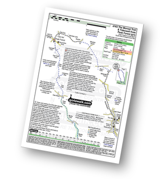
Vital Statistics:
| Length: | 7.75 miles (12.5 km) |
| Ascent: | 840ft (256m) |
| Time: | 3.75hrs |
| Grade: | |
Route Summary:
Miller's Dale Station - The Monsal Trail - The River Wye - Miller's Dale - Water-cum-Jolly Dale - Monsal Head Viaduct - Monsal Head - Upperdale - Cressbrook Mill - The River Wye - Water-cum-Jolly Dale - Litton Mill - Bellamy's Bank - Miller's Dale Station
|
Vital Statistics:
| Length: | 9.75 miles (15.5 km) |
| Ascent: | 1,431ft (436m) |
| Time: | 5 hrs |
| Grade: |  |
Route Summary:
Miller's Dale Station - Monks Dale - The Limestone Way - Tideswell - Litton - Tansley Dale - Cressbrook Dale - Cressbrook - The Monsal Trail - Water-cum-Jolly Dale - Litton Mill - Miller's Dale - Miller's Dale Station
|
Vital Statistics:
| Length: | 7.25 miles (11.5 km) |
| Ascent: | 1,411ft (430m) |
| Time: | 4 hrs |
| Grade: | |
Route Summary:
Tideswell - The Limestone Way - Monksdale House - Monks Dale - Miller's Dale Station - The Monsal Trail - Miller's Dale - The River Wye - Litton Mill - Tideswell Dale - Tideswell
|
Vital Statistics:
| Length: | 12.75 miles (20.5 km) |
| Ascent: | 1,959ft (597m) |
| Time: | 6.75hrs |
| Grade: |  |
Route Summary:
Peak Forest - Dam Dale - Hay Dale - Dale Head - Peter Dale - Monk's Dale - Miller's Dale - The Monsal Trail - Litton Mill - Tideswell Dale - Tideswell - Brook Bottom (Tideswell) - Batham Gate - Old Peak - Peak Forest
|
Vital Statistics:
| Length: | 15.25 miles (24.5 km) |
| Ascent: | 1,759ft (536m) |
| Time: | 7.25hrs |
| Grade: |  |
Route Summary:
Wye Dale - The River Wye - Blackwell Junction - The Monsal Trail - Chee Dale - Miller's Dale Station - Miller's Dale - Litton Mill - Water-cum-Jolly Dale - Cressbrook - Monsal Dale - White Lodge - Deep Dale - Taddington - Sough Top - Chelmorton - Burrs Farm - Marl Dale - Wye Dale
Send us your photographs and pictures of walks and hikes in the British countryside
If you would like to see your digital photographs as part of this collection, please send them as email attachments (configured for any computer) along with your name to:
and we shall do our best to publish them.
(Guide Resolution = 300dpi. At least = 587 pixels (wide) x 440 pixels (high).)

You can also submit photos via our Facebook Page.
NB. Please indicate where each photo was taken.
NB. To see photographs and pictures from a particular walk choose your walk from Walks or use our Walk Search facility.
To see photographs and pictures on, of or from a particular Mountain, Peak, Top or Hill select from Peaks & Mountains' or enter the Mountain, Peak, Top or Hill Name into our 'Photo Search facility.

To contribute to go4awalk.com or to contact us about anything at all - see Talk To Us. For help see Help.
go4awalk.com and go4awalk.co.uk are registered trademarks of TMDH Limited.
Copyright © 2000-2024 TMDH Limited. All rights reserved.
Copyright | Terms & Conditions | Privacy Statement
A - Z
Walks
Home
Log On/Accounts
Photo Gallery
Walk Ideas and Collections
Fell Facts
Places to Stay
Hill Skills
Walking Questions and Answers
Your Stories
News
Competitions
Product Reviews/Gear Tests
Walking Gear Guides
Peaks and Mountains
Peak Bagging
Find New Walking Friends
Camping
GPS Waypoints for Walking
Walk Search
Talk to us
go4awalk.com Help
Free example walks
Newsletter


