
![]()
White Hill (Forest of Bowland)
544m (1785ft)
The South Pennines and The Forest of Bowland, Lancashire, England
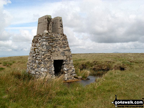
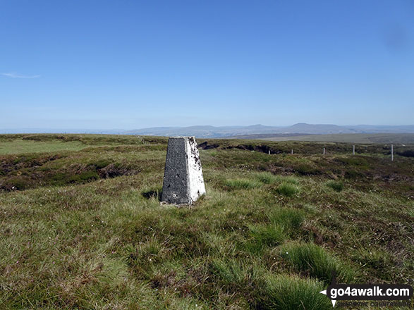
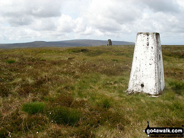
The summit of White Hill (Forest of Bowland) is marked by an Ordnance Survey Trig Point.
You can find White Hill (Forest of Bowland) & all the walks that climb it on these unique free-to-access Interactive Walk Planning Maps: (click/TAP to select)
1:25,000 scale OS Explorer Map (the ones with orange/yellow covers):
1:50,000 scale OS Landranger Map (the ones with pink/magenta covers):
White Hill (Forest of Bowland) on our free-to-access 'Google Style' Peak Bagging Map:
See White Hill (Forest of Bowland) and the surrounding tops on our downloadable PDF Peak Bagging Map:
   |
|---|
Vital Statistics:
| Length: | 5.75ml (9km) |
|---|---|
| Ascent: | 1,113ft (339m) |
| Time: | 3.25hrs |
| Grade: |  (Moderate) (Moderate) |
Route Summary:
Cross of Greet Bridge - Near Crosty Clough - Shooters' Huts - Far Costy Clough - White Hill (Forest of Bowland) - Botton Head Hill - Whitray Fell - Cross of Greet - Cross of Greet Bridge
|
|---|
Vital Statistics:
| Length: | 8.75ml (14km) |
|---|---|
| Ascent: | 1,615ft (492m) |
| Time: | 5 hrs |
| Grade: |  (Moderate) (Moderate) |
Route Summary:
Cross of Greet Bridge - Near Crosty Clough - Shooters' Huts - Far Costy Clough - White Hill (Forest of Bowland) - Botton Head Hill - Whitray Fell - Cross of Greet - Great Harlow - Raven's Castle - Crowd Stones - Catlow Fell (Ravens Castle) - Hailshowers Fell - Cold Stone - Copy Nook - Knottend Well - Crutchenber Fell (Bowland Knotts) - Pike Side - Catlow Farm - Kearsdon Holes - The River Hodder - Cross of Greet Bridge
 Fellow go4awalkers who have already walked, climbed, summited & bagged White Hill (Forest of Bowland)
Adrian Howard walked up White Hill (Forest of Bowland) on February 8th, 2012 [from/via/route] from The Cross of Greet
Christine Shepherd climbed White Hill (Forest of Bowland) on July 1st, 2018 [from/via/route] Walked from Cross of Greet Bridge using walk l155 [with] On my own [weather] Glorious sunshine with a welcome breeze. - The final approach to this summit when the path ends is hard work. There are a lot of peat bogs which were dry today but still quite hard to negotiate. The views from the summit are worth the effort though & the onward route is fine.
Mark Davidson bagged White Hill (Forest of Bowland) on June 23rd, 2008 [with] Alone [weather] Quite good for the South Pennines
Tony Rogerson hiked White Hill (Forest of Bowland) on July 22nd, 2016 [from/via/route] Slaidburn Croasdale White Hill Stocks Reservoir Slaidburn [with] John Ray Luke Floss [weather] Warm & mostly sunny
To add (or remove) your name and experiences on this page - Log On and edit your Personal Mountain Bagging Record
Send us your photographs and pictures on, of, or from White Hill (Forest of Bowland)
If you would like to add your walk photographs and pictures featuring views from, on or of White Hill (Forest of Bowland) to this page, please send them as email attachments (configured for any computer) along with your name to:
and we shall do our best to publish them.
(Guide Resolution = 300dpi. At least = 660pixels (wide) x 440 pixels (high).)

You can also submit photos via our Facebook Page.
NB. Please indicate where each photo was taken.


