
![]()
Sale How (Skiddaw)
666m (2185ft)
The Northern Fells, The Lake District, Cumbria, England
Not familiar with this top?
You can walk/hike to the top of Sale How (Skiddaw) by using this easy‑to‑follow route map:
Walk c186 Lonscale Fell and Skiddaw from Gale Road (Underscar) nr Keswick
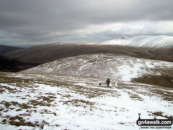
The highest point in the Northern Fells
   |
|---|
Vital Statistics:
| Length: | 10.25ml (16.5km) |
|---|---|
| Ascent: | 2,850ft (869m) |
| Time: | 6½ hrs |
| Grade: |  (Hard) (Hard) |
Route Summary:
Keswick - Gale Road (Underscar) Nr Keswick - Lonscale Fell - Jenkin Hill - Little Man (Skiddaw) - Skiddaw - Sale How (Skiddaw) - Skiddaw House - Gale Road (Underscar) Nr Keswick.
See Sale How (Skiddaw) and the surrounding tops on our free-to-access 'Google Style' Peak Bagging Maps:
The Northern Fells of The Lake District National Park
Less data - quicker to download
The Whole of The Lake District National Park
More data - might take a little longer to download
See Sale How (Skiddaw) and the surrounding tops on our unique, downloadable, PDF Peak Bagging Maps:

NB: Whether you print off a copy or download it to your phone, these PDF Peak Baggers' Maps might prove incredibly useful when your are up there on the tops and you cannot get a phone signal.
*This version is marked with the walk routes you need to follow to Walk all 214 Wainwrights in just 59 walks.
You can find Sale How (Skiddaw) & all the walks that climb it on these unique free-to-access Interactive Walk Planning Maps:
1:25,000 scale OS Explorer Map (orange/yellow covers):
1:50,000 scale OS Landranger Maps (pink/magenta covers):
 Fellow go4awalkers who have already walked, climbed, scaled, summited, hiked & bagged Sale How (Skiddaw)
Sarah Gunn walked up Sale How (Skiddaw) on July 27th, 2024 [from/via/route] From Gale Road car park [with] Martin Gunn
Vincent Clarke climbed it on February 2nd, 2023 [from/via/route] Gale road [with] Cal n Louis [weather] Worst yet
Christine Shepherd bagged it during August, 1997 [from/via/route] Gale Road Car Park [with] My husband Peter [weather] Hot but misty - Had forgotten I'd climbed this but have checked back in the book I used to climb Skiddaw in 1997 & sure enough Sale How was climbed on our way back.Climbed again on 30.06.21 using walk c186.
Kevin Foster hiked Sale How (Skiddaw) on March 30th, 2021 [from/via/route] Skiddaw. [with] By myself. [weather] Sunny to start then ascending into cloud. Cloud inversion on the top of Skiddaw which was cloud free. - The last top of the day was Sale How which was easily taken via a long grassy descent from the col between Skiddaw & Little Man. There still remained a considerably long walk back to the parked car at Latrigg first via Skiddaw House & then along the superb terrace path below the imposing crags of Lonscale Fell which was by now in full sunlight. How annoying!
Mark Davidson summited on March 10th, 2005 [with] Mike [weather] Bit wintery with lots of snow on the summits
Ray O'hara conquered it on February 27th, 2014 [from/via/route] Lonscale Fell, Sale How, Skiddaw, Skiddaw little man [weather] Light powdering of snow. - Blowing a hurricane on top of Skiddaw, but all was fine on Sale How.
Iain Taylor scaled it on April 24th, 2011 [from/via/route] Nr Applethwaite (NY 28047 25403)
Matthew Thomas, Adrian Roberts and Louise Sandwith have all walked, climbed & bagged Sale How (Skiddaw).
To add (or remove) your name and experiences on this page - Log On and edit your Personal Mountain Bagging Record
More Photographs & Pictures of views from, on, or of, Sale How (Skiddaw)
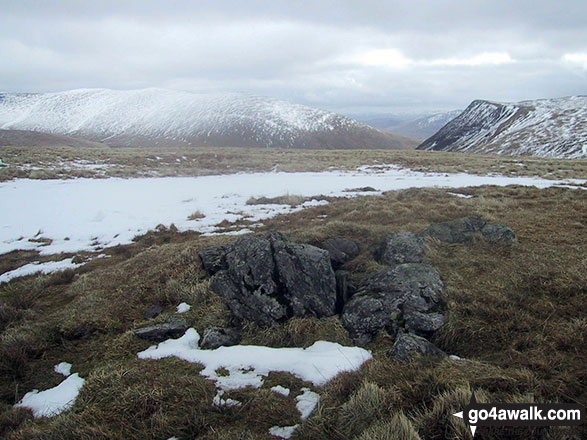
The rocky summit of Sale How (Skiddaw) in the snow with Bowscale Fell (left) and Blencathra or Saddleback with Sharp Edge clearly visible (right) on the horizon

Bowscale Fell (left) and Blencathra or Saddleback with Sharp Edge clearly visible (centre right) in the snow from Sale How (Skiddaw)
Send us your photographs and pictures on, of, or from Sale How (Skiddaw)
If you would like to add your walk photographs and pictures to this page, please send them as email attachments (configured for any computer) along with your name to:
and we shall do our best to publish them.
(Guide Resolution = 300dpi. At least = 660pixels (wide) x 440 pixels (high).)

You can also submit photos via our Facebook Page.
NB. Please indicate where each photo was taken and whether you wish us to credit your photos with a Username or your First Name/Last Name.


