
![]()
Rest Dodd
696m (2284ft)
The Far Eastern Fells, The Lake District, Cumbria, England
You can find Rest Dodd & all the walks that climb it on these unique free-to-access Interactive Walk Planning Maps: (click/TAP to select)
1:25,000 scale OS Explorer Map (the ones with orange/yellow covers):
1:50,000 scale OS Landranger Map (the ones with pink/magenta covers):
See Rest Dodd and the surrounding tops on our free-to-access 'Google Style' Peak Bagging Maps:
See Rest Dodd and the surrounding tops on our downloadable PDF Peak Bagging Maps:
*Walk & bag all 36 Wainwrights in The Far Eastern Fells area of The Lake District in just 8 easy-to-follow circular walks.
*This version is marked with the walk routes you need to follow to Walk all 214 Wainwrights in just 59 walks. Click here for more information.
NB: Whether you print off a copy on to paper or download it to your phone, these PDF Peak Baggers Maps will prove incredibly useful when your are up there on the tops and you cannot get a phone signal!
   |
|---|
Vital Statistics:
| Length: | 12.5ml (20km) |
|---|---|
| Ascent: | 3,769ft (1,149m) |
| Time: | 8½ hrs |
| Grade: |  (Hard) (Hard) |
Route Summary:
Christy Bridge - Martindale - Dale Head Farm - Heck Crag - Angle Tarn - Buck Crag - Brock Crags - Satura Crag - The Nab (Martindale) - Rest Dodd - The Knott - Rampsgill Head - Kidsty Pike - High Raise (Mardale) - Red Crag - Keasgill Head - Christy Bridge
|
|---|
Vital Statistics:
| Length: | 14.5ml (23km) |
|---|---|
| Ascent: | 4,555ft (1,388m) |
| Time: | 9.75hrs |
| Grade: |  (Very Hard) (Very Hard) |
Route Summary:
St Peter's Church (Martindale) - Howtown - Steel Knotts (Pikeawassa) - Keasgill Head - High Raise (Mardale) - Kidsty Pike - Rampsgill Head - The Knott - Rest Dodd - The Nab - Satura Crag - Brock Crags - Angle Tarn (Martindale) - Angletarn Pikes - Bedafel Knott - Beda Head (Beda Fell) - Winter Crag - Christy Bridge - Howegrain Beck - Martindale - St Peter's Church (Martindale) - Howtown
 Fellow go4awalkers who have already walked, climbed, summited & bagged Rest Dodd
Ian Ashton walked up Rest Dodd on November 11th, 2023 [from/via/route] Solo [with] Solo
Simon Boddy climbed Rest Dodd on July 13th, 2022 [from/via/route] Hartsop [with] My girlfriend [weather] Sunny & clear
John Ramsbottom bagged Rest Dodd on June 2nd, 2022 [from/via/route] Howtown, walk c159 Camped under Angletarn Pikes [with] Lola [weather] Sunny weather - solo walk with Lola
Richard Fulcher hiked Rest Dodd on April 25th, 2022 [from/via/route] Parked next to St Martins church in Martindale. Walked to Dale End farm & ascended under Heck Crag up to the path above Angle Tarn. Walked on the main path until veering left up to Rest Dodd. I went on to The Nab whilst Jen waited by the wall. We then walked right around Rest Dodd & up to The Knott. From the Knott we crossed over to Rampsgill Head & on up to High Raise. We followed the ridge towards Low Raise before realising our mistake & correcting. We reached Red Crag & started to descend via Gowk Hill eventually reaching our car after 10h 20m of walking!! [with] Jen [weather] Still & breezy at times on the top with a cold wind. Temp on the tops was about 1 celcius. Some sun but lots of cloud. - Good packed lunch with coffee, fruit cake & chocolate biscuits.
Christine Shepherd summited Rest Dodd on April 15th, 2009 [from/via/route] Walked from Christy Bridge using walk c159 Climbed again from Hartsop 22.6.21 I also added this to a walk on 20.4.22. [with] On my own [weather] Bright & clear - A long quiet walk I climbed this from Hartsop in 2021 On 20.4.22 I decided to add this to a walk as I got to Knott with plenty of time to spare & it looked inviting.
Richard Marchant conquered Rest Dodd on January 28th, 2022 [from/via/route] Parked at Hartsop, walked up Hayeswater Gill to Hayeswater then climbed Easterly up on to The Knott, then North on to Rest Dodd & further on to Then Nab. From The Nab back track to the Rest Dodd but just before reaching the summit traversed to Satura Crag & across to Brock Crag. Slight back track here & followed a path down Calfgate Gill & eventually down to Hayeswater Gill & back to the car. [with] On my own [weather] Dull grey windy day
Nick Dobson scaled Rest Dodd on October 13th, 2021 [from/via/route] Hartsop via Brock Crags & The Nab [with] Margaret & Ralph [weather] Cool dry Autumn day with the Red Deer in abundance - Completed the Far Eastern Fells today. 184 of 214
Paul Ward walked up Rest Dodd on August 13th, 2021 [from/via/route] Started from Howtown Hotel Bonscale Pike, [with] Jamie [weather] Dry, overcast with strong winds on tops.
John Bryers climbed Rest Dodd on May 11th, 2018 [from/via/route] Walked from St. Peter's church up front of Bonscale Pike, Arthur's Pike, Loadpot Hill, Wether Hill, High Raise, Kidsty Pike, Rampsgill Head, Rest Dodd & The Nab dropping back into Bannerdale & road back to church. [with] With Mya my faithful 12 year old Patterdale Terrier. [weather] Weather sunny to start, slight wind on ridges with light rain at times ending with some warm sunshine.
Caroline Winter bagged Rest Dodd on June 3rd, 2021 [from/via/route] Mardale head CP, Riggindale edge, Rough Crag, The Knott, Rest Dodd, Rampsgill Head, High Raise, Riggindale edge [with] Becky [weather] Cloudy & warm, with dense fog in afternoon - To the outlier Rest Dodd & back, before taking a short cut to Rampsgill head from The Knott, but fog rapidly descended & needed to find Rampsgill Head by gps. Eventually, found High Raise with assistance from man familiar with area, but visibility so poor that unable to find route to Kirsty Pike, so needed to back track down Riggindale.
To add (or remove) your name and experiences on this page - Log On and edit your Personal Mountain Bagging Record
. . . [see more walk reports]
More Photographs & Pictures of views from, on or of Rest Dodd
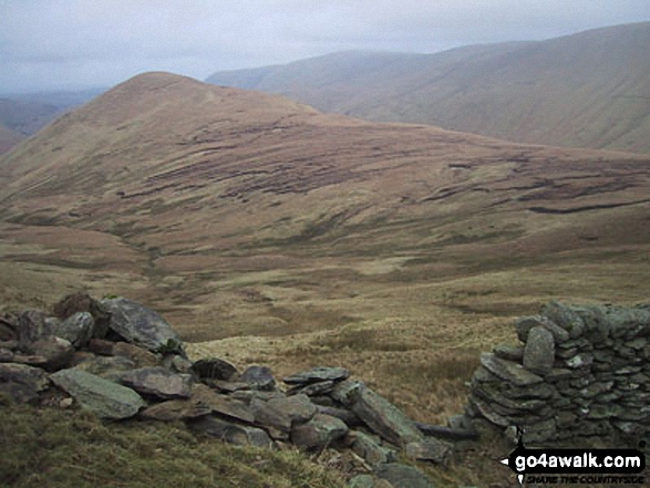
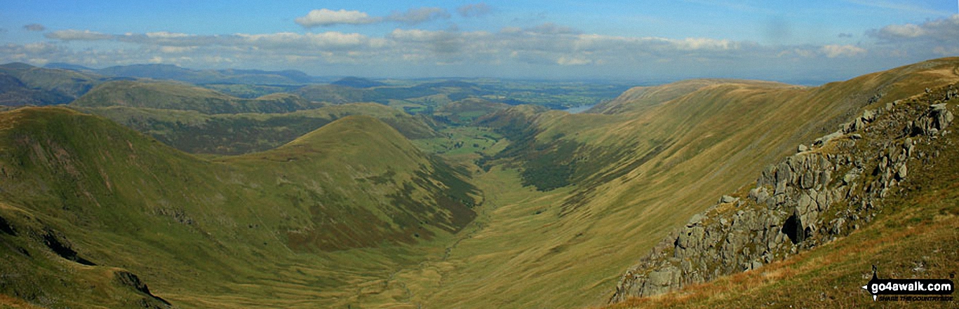
Rest Dodd (far left), The Nab (left), The Ramps Gill Valley, Wether Hill, Wether Hill (South Top) Keasgill Head, Red Crag, Raven Howe and High Raise (Mardale) (right) from Rampsgill Head
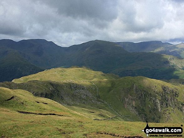
Rest Dodd (centre), The Knott and Rampsgill Head (left) from The Nab (Martindale)
Send us your photographs and pictures on, of, or from Rest Dodd
If you would like to add your walk photographs and pictures featuring views from, on or of Rest Dodd to this page, please send them as email attachments (configured for any computer) along with your name to:
and we shall do our best to publish them.
(Guide Resolution = 300dpi. At least = 660pixels (wide) x 440 pixels (high).)

You can also submit photos via our Facebook Page.
NB. Please indicate where each photo was taken.


