
![]()
Lower Man (Helvellyn)
925m (3036ft)
The Eastern Fells, The Lake District, Cumbria, England
You can find Lower Man (Helvellyn) & all the walks that climb it on these unique free-to-access Interactive Walk Planning Maps: (click/TAP to select)
1:25,000 scale OS Explorer Map (the ones with orange/yellow covers):
1:50,000 scale OS Landranger Map (the ones with pink/magenta covers):
See Lower Man (Helvellyn) and the surrounding tops on our free-to-access 'Google Style' Peak Bagging Maps:
See Lower Man (Helvellyn) and the surrounding tops on our downloadable PDF Peak Bagging Maps:
*Walk & bag all 35 Wainwrights in The Eastern Fells area of The Lake District in just 8 easy-to-follow circular walks.
*This version is marked with the walk routes you need to follow to Walk all 214 Wainwrights in just 59 walks. Click here for more information.
NB: Whether you print off a copy on to paper or download it to your phone, these PDF Peak Baggers Maps will prove incredibly useful when your are up there on the tops and you cannot get a phone signal!
   |
|---|
Vital Statistics:
| Length: | 5ml (8km) |
|---|---|
| Ascent: | 2,649ft (807m) |
| Time: | 4½ hrs |
| Grade: |  (Moderate) (Moderate) |
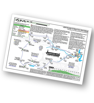
Route Summary:
The Swirls - Helvellyn Gill - Browncove Crags - Lower Man (Helvellyn) - Helvellyn - Lower Man (Helvellyn) - Browncove Crags - Helvellyn Gill - The Swirls
|
|---|
Vital Statistics:
| Length: | 8.75ml (14km) |
|---|---|
| Ascent: | 3,296ft (1,005m) |
| Time: | 6½ hrs |
| Grade: |  (Hard) (Hard) |
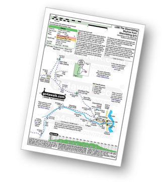
Route Summary:
The Swirls Car Park Thirlmere - Browncove Crags - Lower Man (Helvellyn) - Helvellyn - White Side - Raise (Helvellyn) - Sticks Pass - Sticks Gill - Stanah Gill - Legburthwaite - Thirlmere - Thirlspot - The Swirls Car Park Thirlmere.
|
|---|
Vital Statistics:
| Length: | 10.5ml (17km) |
|---|---|
| Ascent: | 3,575ft (1,090m) |
| Time: | 7½ hrs |
| Grade: | (Hard) |
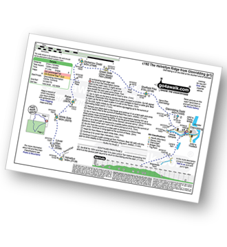
Route Summary:
The Swirls Car Park Thirlmere - Browncove Crags - Lower Man (Helvellyn) - Helvellyn - White Side - Raise (Helvellyn) - Sticks Pass - Stybarrow Dodd - Watson's Dodd - Great Dodd - Legburthwaite - Thirlmere - Thirlspot - The Swirls Car Park Thirlmere.
|
|---|
Vital Statistics:
| Length: | 10.75ml (17km) |
|---|---|
| Ascent: | 3,449ft (1,051m) |
| Time: | 7.25hrs |
| Grade: | (Hard) |
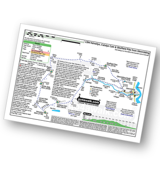
Route Summary:
Glenridding - Birkhouse Moor - Hole-in-the-Wall - Red Tarn (Helvellyn) - Catstye Cam - Swirral Edge - Helvellyn - Lower Man (Helvellyn) - White Side - Raise (Helvellyn) - Sticks Pass - Lucy's Tongue - Glenridding Beck - Glenridding
|
|---|
Vital Statistics:
| Length: | 10ml (16km) |
|---|---|
| Ascent: | 4,020ft (1,225m) |
| Time: | 8 hrs |
| Grade: |  (Hard) (Hard) |
Route Summary:
Glenridding - Glenridding Dodd - Sheffield Pike - Nick Head - Sticks Pass - Raise (Helvellyn) - White Side - Lower Man (Helvellyn) - Helvellyn - Swirral Edge - Catstye Cam - Glenridding Beck - Glenridding Youth Hostel - Glenridding
|
|---|
Vital Statistics:
| Length: | 11.5ml (18.5km) |
|---|---|
| Ascent: | 4,418ft (1,346m) |
| Time: | 8½ hrs |
| Grade: | (Hard) |
Route Summary:
Glenridding - Glenridding Dodd - Sheffield Pike - Nick Head - Glencoyne Head - Hart Side - Green Side (White Stones) - Stybarrow Dodd - Sticks Pass - Raise (Helvellyn) - White Side - Lower Man (Helvellyn) - Helvellyn - Swirral Edge - Catstye Cam - Red Tarn Beck - Glenridding Beck - Glenridding Youth Hostel - Glenridding
|
|---|
Vital Statistics:
| Length: | 13ml (21km) |
|---|---|
| Ascent: | 4,359ft (1,329m) |
| Time: | 9.25hrs |
| Grade: | (Hard) |
Route Summary:
Glenridding - Glenridding Dodd - Sheffield Pike - Green Side - Stybarrow Dodd - Sticks Pass - Raise (Helvellyn) - White Side - Lower Man (Helvellyn) - Helvellyn - Nethermost Pike - High Crag (Helvellyn) - Dollywaggon Pike - Grisdale Tarn - Grisedale Beck - Brownend Plantation - Lanty's Tarn - Keldas - Glenridding
 Fellow go4awalkers who have already walked, climbed, summited & bagged Lower Man (Helvellyn)
Iain Jones walked up Lower Man (Helvellyn) on April 16th, 2011 [from/via/route] Helvellyn [with] Jim Hamilton, Alex Walker & Rob Argent - 05 August 2017 - The Wainwright 60 - Day 3 (Helvellyn); 02 December 2023 - via Swirral Edge with Fell Top Assessor
Chris Hughes climbed Lower Man (Helvellyn) on June 28th, 2023 [from/via/route] Thirlmere car park [weather] mist / drizzle
Melfyn Parry bagged Lower Man (Helvellyn) on May 23rd, 2023 [from/via/route] Started walk from the car park at the Patterdale Hotel, followed route C427 with a couple of changes. Climbed over Striding Edge & then on to Helvellyn but then took a detour to walk out to Lower Man then doubled back to Helvellyn before descending Swirral Edge to then climb too summit of Catstye Cam. From here we descended to Hole in the Wall & then went out to Birkhouse Moor & rather than doubling back to Hole in the Wall to repeat the path back to the carpark we continued beyond the summit along easy to follow paths which led back down to join the return route at NY377158, making a total of 16.4Km [with] With DS [weather] Sunny spells & quite warm at times especially on uphill sections when in lea of the breeze. On the tops the breeze was chilly. - Stunning views in all directions.
Nina Adams hiked Lower Man (Helvellyn) on April 22nd, 2023 [from/via/route] Helvellyn YHA @Glenridding - Glenridding Common - White Side - Lower Man - Helvellyn - Lower Man - Whiteside - YHA [with] Craig [weather] 7.8° Rain Poor visibility
Christine Shepherd summited Lower Man (Helvellyn) on June 11th, 2006 [from/via/route] Walked from Glennridding using walk c394. Repeated this walk solo on 15.4.21 on a glorious day. Climbed again on 7.5.22 [with] My daughter, Rebecca. [weather] Hot & sunny
Martin Woods conquered Lower Man (Helvellyn) on June 6th, 2021 [from/via/route] From Patterdale - Birks to Fairfield round to Hellvelyn & down to Glenridding [with] Ackers and Crush [weather] Sun, 22 deegrees v.little breeze
Angela Haworth scaled Lower Man (Helvellyn) on March 25th, 2002 [from/via/route] From Thirlspot return via Dollywagon Pike, Grisdale Tarn - Dunmail Raise [with] companion [weather] Dry - Broke leg between Grisdale Tarn & Dunmail Raise - walked myself to the road.
Kevin Foster walked up Lower Man (Helvellyn) on June 29th, 2019 [from/via/route] Catstyecam, Swirral Edge & Helvellyn [with] Peter and Henry. [weather] Baking hot. - Report to follow.
Margaret Richards climbed Lower Man (Helvellyn) on September 12th, 2018 [from/via/route] c113 from Thirlmere [with] Don [weather] Sunny & windy - Fantastic views
Lucy Perchard bagged Lower Man (Helvellyn) on September 5th, 2018 [from/via/route] the Helvellyn range ascending from Legburthwaite to Sticks Pass & then along the ridge to Raise, Whiteside, Lower Man, Helvellyn, Nethermost Pike & Dollywagon Pike, then down to Grisedale Tarn, back up to Seat Sandal before descending down to Grasmere. [with] Tony [weather] Mostly sunny
To add (or remove) your name and experiences on this page - Log On and edit your Personal Mountain Bagging Record
. . . [see more walk reports]
More Photographs & Pictures of views from, on or of Lower Man (Helvellyn)
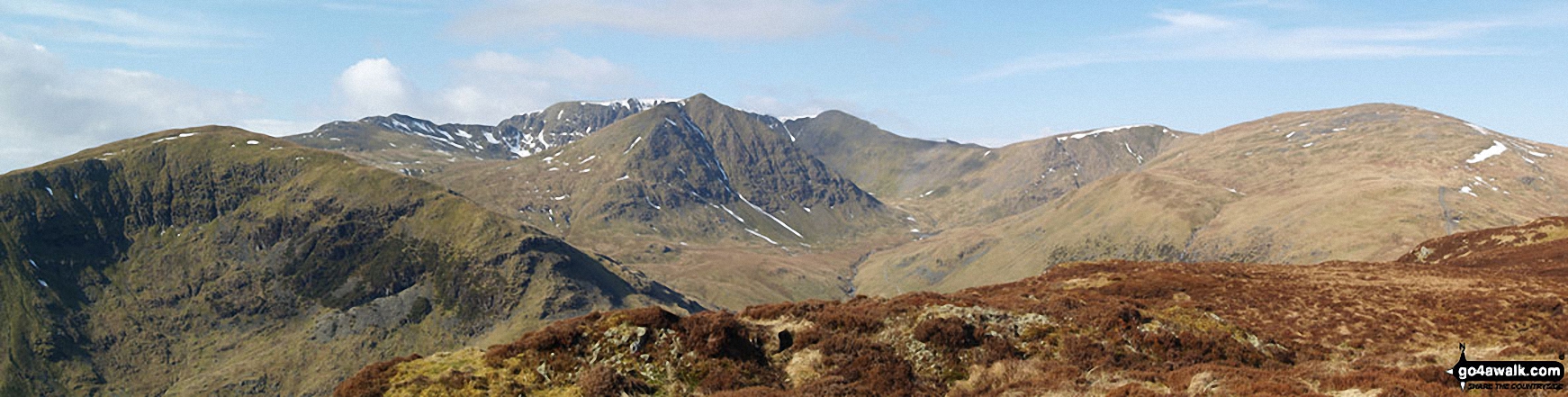
Birkhouse Moor (foreground left), Catstye Cam (foreground centre), White Side (centre right) and Raise (Helvellyn) (right) with Striding Edge, Helvellyn and Lower Man (Helvellyn) in the background from Sheffield Pike
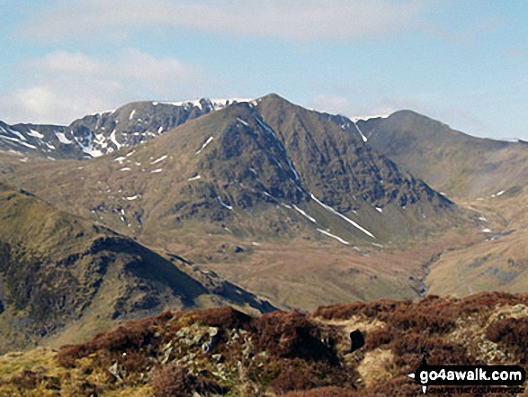
Catstye Cam (centre) with Striding Edge (left), Helvellyn and Lower Man (Helvellyn) (right) in the background from Sheffield Pike

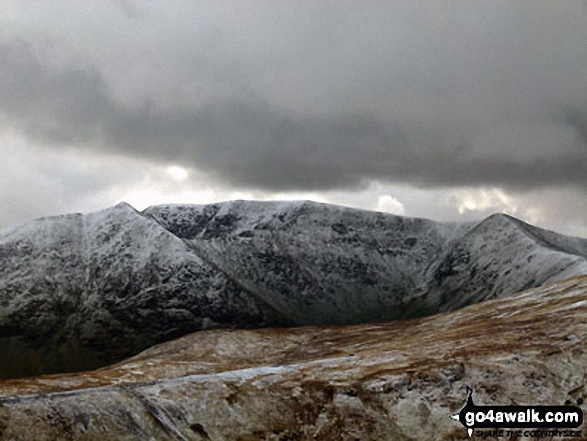
Catstye Cam (left), Helvellyn (centre) and Lower Man (Helvellyn) (right) from near White Side
Send us your photographs and pictures on, of, or from Lower Man (Helvellyn)
If you would like to add your walk photographs and pictures featuring views from, on or of Lower Man (Helvellyn) to this page, please send them as email attachments (configured for any computer) along with your name to:
and we shall do our best to publish them.
(Guide Resolution = 300dpi. At least = 660pixels (wide) x 440 pixels (high).)

You can also submit photos via our Facebook Page.
NB. Please indicate where each photo was taken.


