
![]()
High House Tarn Top
684m (2245ft)
The Southern Fells, The Lake District, Cumbria, England
You can find High House Tarn Top & all the walks that climb it on these unique free-to-access Interactive Walk Planning Maps: (click/TAP to select)
1:25,000 scale OS Explorer Map (the ones with orange/yellow covers):
1:50,000 scale OS Landranger Maps (the ones with pink/magenta covers):
See High House Tarn Top and the surrounding tops on our free-to-access 'Google Style' Peak Bagging Maps:
See High House Tarn Top and the surrounding tops on our downloadable PDF Peak Bagging Maps:
*Walk & bag all 30 Wainwrights in The Southern Fells area of The Lake District in just 11 easy-to-follow circular walks.
*This version is marked with the walk routes you need to follow to Walk all 214 Wainwrights in just 59 walks. Click here for more information.
NB: Whether you print off a copy on to paper or download it to your phone, these PDF Peak Baggers Maps will prove incredibly useful when your are up there on the tops and you cannot get a phone signal!
   |
|---|
Vital Statistics:
| Length: | 9.75ml (15.5km) |
|---|---|
| Ascent: | 3,046ft (928m) |
| Time: | 6½ hrs |
| Grade: |  (Hard) (Hard) |
Route Summary:
Seatoller (Borrowdale) - Strands Bridge - Borrowdale - The Combe - Thornythwaite Fell - Comb Head - Glaramara - Looking Steads (Glaramara) - Red Beck - Red Beck Top - Allen Gill - High House Tarn - High House Tarn Top - Allen Crags - Esk Hause - Ruddy Gill - Sprinkling Tarn - Sty Head - Sty Head Tarn - Sty Head Gill - Stockley Bridge - Grains Gill - Seathwaite - The Allerdale Ramble - Seatoller (Borrowdale)
|
|---|
Vital Statistics:
| Length: | 10.5ml (17km) |
|---|---|
| Ascent: | 3,407ft (1,038m) |
| Time: | 7.25hrs |
| Grade: | (Hard) |
Route Summary:
Seatoller (Borrowdale) - Big Stanger Gill - Hanging Haystack Crag - Alisongrass Crag - Rosthwaite Fell (Bessyboot) - Tarn At Leaves - Rosthwaite Cam (Rosthwaite Fell) - Dovenest Top - Combe Door Top - Combe Head - Glaramara - Looking Steads (Glaramara) - Red Beck Top - High House Tarn Top - Allen Crags - Sprinking Tarn - Seathwaite Fell (South Top) - Seathwaite Fell - Grains Gill - The Allerdale Ramble - Stockley Bridge - Seathwaite - Thornythwaite Farm - Strands Bridge - The River Derwent - Seatoller (Borrowdale)
|
|---|
Vital Statistics:
| Length: | 10.5ml (17km) |
|---|---|
| Ascent: | 3,384ft (1,031m) |
| Time: | 7.25hrs |
| Grade: | (Hard) |
Route Summary:
Stonethwaite - Big Stanger Gill - Hanging Haystack Crag - Alisongrass Crag - Rosthwaite Fell (Bessyboot) - Tarn At Leaves - Rosthwaite Cam (Rosthwaite Fell) - Dovenest Top - Combe Door Top - Combe Head - Glaramara - Looking Steads (Glaramara) - Red Beck Top - High House Tarn Top - Allen Crags - Esk Hause - Allencrags Gill - Langstrath - Stonethwaite
|
|---|
Vital Statistics:
| Length: | 10.5ml (17km) |
|---|---|
| Ascent: | 4,693ft (1,430m) |
| Time: | 8½ hrs |
| Grade: |  (Hard) (Hard) |
Route Summary:
Seatoller (Borrowdale) - Strands Bridge - Borrowdale - The Combe - Thornythwaite Fell - Comb Head - Glaramara - Looking Steads (Glaramara) - Red Beck - Red Beck Top - Allen Gill - High House Tarn - High House Tarn Top - Allen Crags - Esk Hause - Ruddy Gill - Sprinkling Tarn - Sty Head - Great Gable - Westmorland Cairn - Windy Gap - Green Gable - Gillercomb Head - Brandreth - Grey Knotts - Honister Hause - Honister Pass - Wainwright's Coast to Coast Walk - Seatoller (Borrowdale)
 Fellow go4awalkers who have already walked, climbed, summited & bagged High House Tarn Top
John Tippins walked up High House Tarn Top on October 27th, 2022 [from/via/route] From Seatoller [with] Alone [weather] Dry to start with & mild - t-shirt mild for the ascent. Started to rain mid-morning, then rained on & off all day. Very low cloud - in cloud for most of the walk. Wind quite calm. - Not an enjoyable walk, particularly the stretch from Rosthwaite to Glaramara. Confronted with many sheer rock faces that you have to find a way over. And I forgot the warning about the scree at Aaron Crags until I was part way down. It was bad. 'Not for the faint hearted' - you're not kidding.
Christine Shepherd climbed High House Tarn Top on July 15th, 2007 [from/via/route] From Seatoller using walk c301 [with] Solo before leading a group from St Georges Church, Leeds on 15.7.06 [weather] Sunny
Kevin Foster bagged High House Tarn Top on June 1st, 2021 [from/via/route] Seathwaite. [with] By myself. [weather] Sunny & Hot. - There were too many tops visited on this walk to give a full description of each one. The route of the walk roughly followed the Sty Head Tarn path via Stockley Bridge, then as the path levelled off a steep ascent up the flanks of Seathwaite Fell to reach Wainwright's Top, then the true summit (Main Top) followed by a subsidiary top (South Top). The route then went past Sprinkling Tarn & climbed to Esk Hause (not the true one) before turning left & climbing to the summit of Allen Crags. Numerous tops were then visited along the undulating & interesting ridge including Glaramara & Rosthwaite Fell before descending off the ridge by dropping left at Tarn at Leaves into the ravine of Rottenstone Gill (not as bad as it sounds!). On reaching the lane to Thorneythwaite another left turn down a tarmac road & across field paths eventually led me back to the car parked at Seathwaite. Another tiring but superb day in The Lakes. I do feel as though I am saving the best until last with these Western & Southern Fells?
Simon Myerscough hiked High House Tarn Top on April 1st, 2007 [from/via/route] C139 [with] Martin & Bill [weather] Sunny, chilly-ish
Stephen Eddy summited High House Tarn Top on July 1st, 2017 [from/via/route] Wasdale Head via Esk Hause & Allen Crags [with] Mike Woodhouse,Tony Harris, Martin Bayliss [weather] Sunny in morning, rainy upon descent.
Mark Davidson conquered High House Tarn Top on October 16th, 2005 [with] Mike [weather] Typical October Day - a bit grey
Iain Taylor scaled High House Tarn Top on April 4th, 2010 [from/via/route] Seathwaite (NY 23591 12285)
Ray O'hara walked up High House Tarn Top on April 17th, 2011 [weather] Clear skies & sunny.
Patrick Rogozinski, Matthew Thomas, Adrian Roberts and Phyllis Mcgibbon have all walked, climbed & bagged High House Tarn Top.
To add (or remove) your name and experiences on this page - Log On and edit your Personal Mountain Bagging Record
More Photographs & Pictures of views from, on or of High House Tarn Top
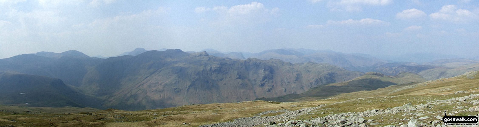
*Scafell Pike (far left back) and The Borrowdale Fells featuring Allen Crags, High House Tarn Top, Red Beck Top, Looking Stead, Glaramara, Comb Head, Comb Door Top, Dovenest Top and Rosthwaite Fell (Bessyboot) from High Raise (Langdale)
Send us your photographs and pictures on, of, or from High House Tarn Top
If you would like to add your walk photographs and pictures featuring views from, on or of High House Tarn Top to this page, please send them as email attachments (configured for any computer) along with your name to:
and we shall do our best to publish them.
(Guide Resolution = 300dpi. At least = 660pixels (wide) x 440 pixels (high).)

You can also submit photos via our Facebook Page.
NB. Please indicate where each photo was taken.


