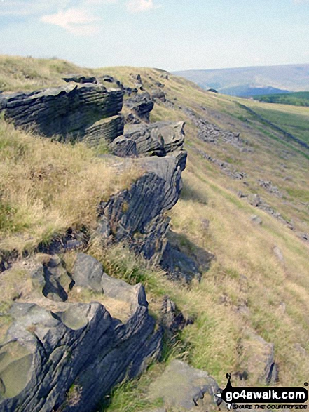
Not Logged On
Bagged

Cown Edge Rocks
410m (1346ft)

Cown Edge Rocks in The Dark Peak Area The Peak District National Park Derbyshire    England
Cown Edge Rocks

Photograph by Richard Hooper

Bridget

Cown Edge Rocks is on interactive maps:
OS Explorer (Orange Covers) sheet: OL1
OS Landranger (Pink Covers) sheet: 109
Find Cown Edge Rocks using Google Maps

Cown Edge Rocks is on Peak Bagging Map and Hill Tick List:
The Dark Peak Area of The Peak District National Park


If you LOG ON and then RELOAD this page it will display when you climbed, bagged and conquered Cown Edge Rocks, what the weather was like, who you went with and any other comments you might like to add to remind you of that fantastic day. And since you can also access your Personal Mountain & Hill Bagging Record via go4awalk Mobile you can quickly & easily record, edit and view your achievements - whether you are at home/work on your desktop computer or in the pub/at the top of a mountain with your iPhone, HTC Android or Blackberry Smart Phone. Furthermore, you can even download your Personal Mountain & Hill Bagging Record as a .csv file for importing into spreadsheet software such as Excel or NeoOffice. For more details see Your Personal Mountain, Top, Peak and Hill Bagging Record.


For walk routes maps up Cown Edge Rocks click here:


See Cown Edge Rocks & walks up it on a Google Map:


Other walkers who hiked, climbed, bagged and summited Cown Edge Rocks Fellow go4awalkers who have walked up, climbed & bagged Cown Edge Rocks

Mark Davidson has walked, climbed & bagged Cown Edge Rocks.

To add (or remove) your name and experiences on this page - Log On and edit your Personal Mountain Bagging Record


More Photographs & Pictures of views from, on or of Cown Edge Rocks

. . . in no particular order

Kinder Scout from Cown Edge Rocks

1. Kinder Scout from Cown Edge Rocks
Photo: Richard Hooper (17)

On Cown Edge Rocks

2. On Cown Edge Rocks
Photo: Richard Hooper (19)

Cown Edge Rocks from near Rowarth

3. Cown Edge Rocks from near Rowarth
Photo: Richard Hooper (13)

Cown Edge Rocks

4. Cown Edge Rocks
Photo: Richard Hooper (20)


Send us your photographs and pictures on, of, or from Cown Edge Rocks

If you would like to add your walk photographs and pictures featuring views from, on or of Cown Edge Rocks to this page, please send them as email attachments (configured for any computer) along with your name to:


and we shall do our best to publish them.

(Guide Resolution = 300dpi. At least = 400pixels (wide) x 300 pixels (high).)

Send us your photographs and pictures on, of, or from Cown Edge Rocks via Facebook

You can also submit photos via our Facebook Page.

NB. Please indicate where each photo was taken.


You can walk or hike Cown Edge Rocks with any of these 2 route maps:

Walk d177 Cown Edge Rocks from Charlesworth

Route Summary: - Charlesworth, The Cown Edge Way, Coombe Edge, Coombe Rocks, Cown Edge Rocks, Coombes Tor, Far Coombes, Charlesworth.

Length: 6km (3.75 miles) | Ascent: 250m (820ft) | Allow at least: 2.25hrs | Grade:Walk Grades Explanation and Help Easy


Walk d171 Lantern Pike and Cown Edge Rocks from Hayfield

Route Summary: - Hayfield, Sett Valley Trail, Birch Vale, The River Sett, The Pennine Bridleway, Lantern Pike, Rowarth, Cown Edge Rocks, Hollingwood Clough, Middle Moor (Hayfield), The Snake Path, Hayfield.

Length: 17km (10.5 miles) | Ascent: 626m (2055ft) | Allow at least: 6hrs | Grade:Walk Grades Explanation and Help Moderate


Bookmark/Share this page with:

Cown Edge Rocks - Walk Photographs and PicturesDelecious | Cown Edge Rocks - Walk Photographs and PicturesDigg | Cown Edge Rocks - Walk Photographs and PicturesFacebook | Cown Edge Rocks - Walk Photographs and Picturesreddit | Cown Edge Rocks - Walk Photographs and PicturesStumbleUpon | Cown Edge Rocks - Walk Photographs and PicturesTwitter

Log On/Off

Follow go4awalk.com on Twitter Follow go4awalk.com on Facebook


Win HJ Socks worth £120 competition


Home


Find new Friends to go walking with
Walk all 214 Wainwrights in just 59 Walks. Download GPS Waypoints - Great Walks you must not miss!
Walk The Yorkshire Three Peaks Challenge Walk - All the Latest Route Information, GPS Waypoints and Split Times to keep you on Schedule
Walk The British Three Peaks Challenge Walk - All the Latest Route Information and GPS Waypoints
See our pick of The Best Walks in The Lake District - Great Walks you must not miss!
Walk our pick of the Best Lake District Ridge Walks - Great Walks you must not miss!
Walk our pick of the Best Lake District Walks to do in the rain - Great Walks you must not miss!
Walk our pick of The Best Walks in Snowdonia - Great Walks you must not miss!
Walk our pick of The Best Ridge Walks in Wales - Walks you must not miss!
Walk our pick of The Best Walks in The Brecon Beacons - Great Walks you must not miss!
Walk our pick of The Best Walks in The Yorkshire Dales - Walks you must not miss!
Walk our pick of The Best Walks in The Peak District - Walks you must not miss!
Walk our pick of The Best Walks in The Forest of Bowland - Walks you must not miss!
Walk our pick of The Best Walks in Shropshire - Walks you must not miss!
Walk our pick of The Best Walks in Cheshire - Walks you must not miss!
Walk our pick of The Best Walks in Lancashire - Walks you must not miss!
Not sure where to walk next? Try Peak Bagging - Great Walks you must not miss!
Not sure where to walk next? Walk part of a National Trail - Great Walks you must not miss!
Walks with Downloadable and Uploadable GPS Waypoint Data
GET 10% OFF Ordnance Survey Maps with FREE postage and packing

Walking Kit Gear Tested by Walkers

Walking Gear Tested by Walkers
Full Site Search