Peak Bagging the 84 Mountains, Tops, Peaks and Hills in The North Pennines, England
![]()
The North Pennines covers parts of Cumbria, County Durham and Northumberland and is the area enclosed by:
- The A689 from Carlisle to Brampton and then the A69 from Brampton to Newcastle-upon-Tyne to the North
- The North Sea from Newcastle-upon-Tyne to Middleborough to the East
- The River Tees from Middlesborough to Barnard Castle, the northern edge of the Yorkshire Dales National Park to the M6 near Shap to the South
- The M6 from Shap to Carlisle to the West
There are 84 'tops' to walk up, bag and conquer, the highest point is Cross Fell and the area includes:
 Downloadable Peak Baggers Map you can Print or Save to your Phone detailing the The North Pennines
| 0 | Wainwrights | |
| 27 | Mountains (aka Hewitts) | |
| 20 | Deweys | |
| 37 | Nuttalls | |
| 0 | Wainwright Outlying Fells | |
| 6 | Marilyns | |
| 26 | Hills (aka Bridgets) and | |
| 50 | Mountains, Tops, Peaks or Hills with a Trig Point on or near the top |
View all 84 Mountains, Peaks, Tops and Hills in The North Pennines:
- On a Downloadable PDF you can Print or Save to your Phone#
- On an Interactive Google Map (loads faster)
- On an Interactive Google Map with a list of tops below it (makes it easier to locate a particular top)
- On a Detailed List in:
Alphabetical Order | Height Order - On one page with 'yet-to-be-bagged' listed 1st & then 'already-bagged' tops listed 2nd in:
Alphabetical Order | Height Order (must be logged on) - On one page with 'already-bagged' tops listed 1st & then 'yet-to-be-bagged' tops listed 2nd in:
Alphabetical Order | Height Order (must be logged on)
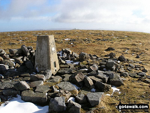 The summit of Cross Fell, the highest point in The North Pennines
Photo: Ryan Pearson
# Whether you print a copy or download it to your phone, this Peak Baggers' Map will prove incredibly useful if you want to know what's what when you are up in the mountains and cannot get a phone signal
To contribute to go4awalk.com or to contact us about anything at all - see Talk To Us. For help see Help.
go4awalk.com and go4awalk.co.uk are registered trademarks of TMDH Limited.
Copyright © 2000-2024 TMDH Limited. All rights reserved.
Copyright | Terms & Conditions | Privacy Statement
A - Z
Walks
Home
Log On/Accounts
Photo Gallery
Walk Ideas and Collections
Fell Facts
Places to Stay
Hill Skills
Walking Questions and Answers
Your Stories
News
Competitions
Product Reviews/Gear Tests
Walking Gear Guides
Peaks and Mountains
Peak Bagging
Find New Walking Friends
Camping
GPS Waypoints for Walking
Walk Search
Talk to us
go4awalk.com Help
Free example walks
Newsletter


