23 easy-to-follow walk route maps of all grades in the Loch Leven to Connel Bridge, Strath of Orchy and Glen Lochy region of Scotland
Twenty-three easy-to-follow walk route maps of all grades in the Loch Leven to Connel Bridge, Strath of Orchy and Glen Lochy region of Scotland in Walk Grade Order
Loch Leven to Connel Bridge, Strath of Orchy and Glen Lochy is the area enclosed by an imaginary line connecting:
- Rubh' a' Bhaid Bheithe to Rannoch Station via Loch Linnhe, South Ballachulish, Glencoe, Loch Leven & Black Water to the North
- Rannoch Station to Tyndrum via the railway lineLoch Tulla & Bridge of Orchy to the East
- Tyndrum to Lynn of Lorn via the A85 through Glen Lochy, Dalmally, Loch Awe, The River Awe, The Pass of Brander, Taynuilt & Loch Etive to the South
- Lynn of Lorn to Rubh' a' Bhaid Bheithe via Loch Linnhe to the West
See this list of walks, routes & maps in:
Grade Order |
Length Order |
Time Order |
Walk Number or Start Location Order
NB. To reverse (toggle) this order, click Grade Order again
   |
Vital Statistics:
| Length: | 11.5 miles (18.5 km) |
| Ascent: | 7,020ft (2,139m) |
| Time: | 11½ hrs |
| Grade: |  |
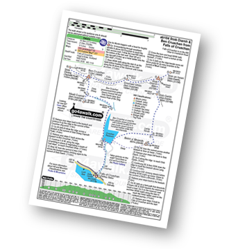
Route Summary:
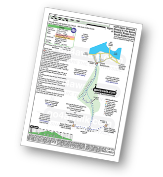
Falls of Cruachan - Loch Awe - Cruachan Reservoir - Coire Dearg - Meall Cuanail - Stob Dearg (Taynuilt Peak) - Ben Cruachan - Coire Caorach - Drochaid Ghlas (Ben Cruachan) - Stob Diamh - Stob Garbh (Stob Diamh) - Lairig Torran - Beinn a' Bhuiridh - Cruachan Reservoir - Falls of Cruachan
|
Vital Statistics:
| Length: | 1.5 miles (2.5 km) |
| Ascent: | 20ft (6m) |
| Time: | 1 hrs |
| Grade: |  |
|
Vital Statistics:
| Length: | 4.5 miles (7 km) |
| Ascent: | 1,241ft (378m) |
| Time: | 3 hrs |
| Grade: |  |
|
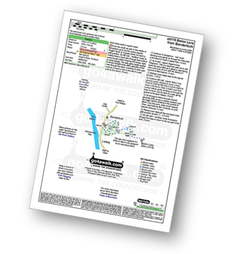
Vital Statistics:
| Length: | 13.75 miles (22 km) |
| Ascent: | 4,523ft (1,378m) |
| Time: | 9½ hrs |
| Grade: | |
Route Summary:
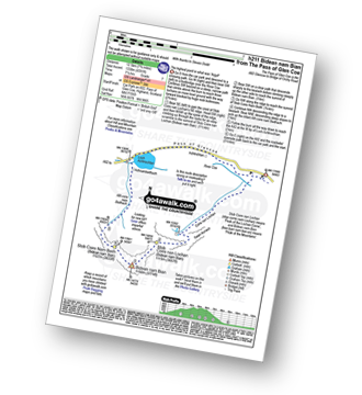
Victoria Bridge - Forest Lodge - Abhainn Shira - Clashgour Estate - Clashgour Hut - Caolain Dubh - Stob a' Choire Odhair (Black Mount) - Aoneach Eagach - Core na Muic - Stob Maol - Stob Ghabhar - Core Chaolain - Core Ghabhar - Sron a';Ghearrain (Stob Ghabhar) - Bealach Core Laoghan - Stob a' Bhruaich Leith (Stob Ghabhar) - Bealach Core Laoghan - Lurg Bhan - Alt Ghabhar - Clashgour - Abhainn Shira - Clashgour Hut - Forest Lodge - Victoria Bridge
|
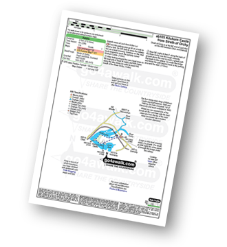
Vital Statistics:
| Length: | 8.5 miles (13.5 km) |
| Ascent: | 4,378ft (1,334m) |
| Time: | 7½ hrs |
| Grade: |  |
Route Summary:
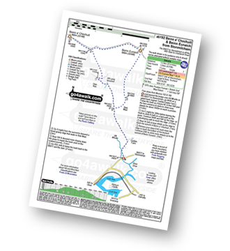
B8077 - Allt Mhoille - Castles Farm - Allt Lairig Lanachan - Glen Noe - Beinn a' Chochuill - Beinn Eunaich - Stob Maol - Castles Farm - B8077
|
Vital Statistics:
| Length: | 9.5 miles (15 km) |
| Ascent: | 6,173ft (1,881m) |
| Time: | 10 hrs |
| Grade: |  |
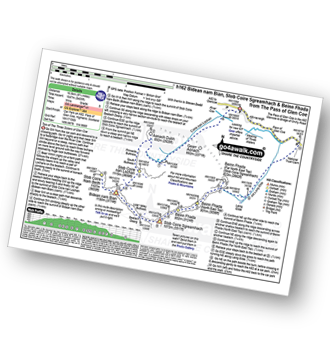
Route Summary:
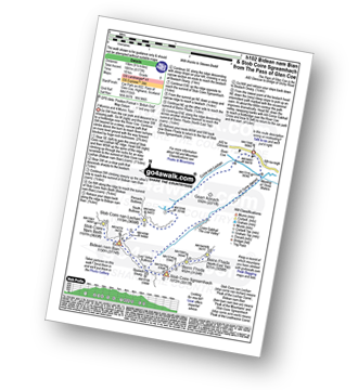
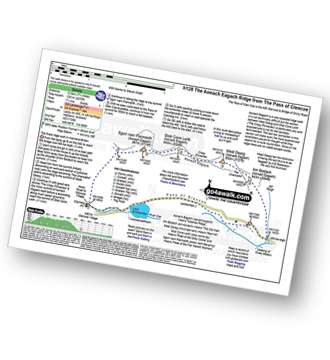
The Pass of Glencoe - The River Coe - Coire Nan Lochan - Stob Coire Nan Lochan (Bidean Nam Bian) - Bidean Nam Bian - Stob Coire Nam Beith (Bidean Nam Bian) - Bidean Nam Bian - Lost Valley Buttress - Bealach Dearg - Stob Coire Sgreamhach - Beinn Fhada (Stob Coire Sgreamhach) - Beinn Fhada (Stob Coire Sgreamhach) (North East Top) - Beinn Fhada (Stob Coire Sgreamhach) - Stob Coire Sgreamhach - Bealach Dearg - Coire Gabhail (The 'Lost Valley') - Allt Corrie Gabhail - The Pass of Glencoe
|
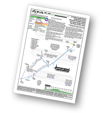
Vital Statistics:
| Length: | 6.5 miles (10.5 km) |
| Ascent: | 3,318ft (1,011m) |
| Time: | 6 hrs |
| Grade: |  |
Route Summary:
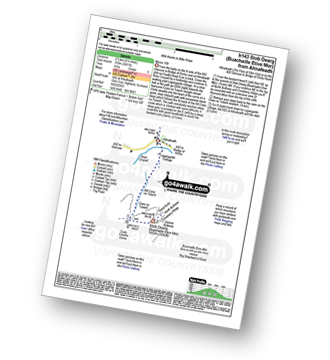
The Pass of Glencoe - Mam Buidhe - Stob Coire Raineach (Buachaille Etive Beag) - Buachaille Etive Beag (Stob Dubh) - Lairig Eilde - The Pass of Glencoe
|
Vital Statistics:
| Length: | 9.25 miles (14.5 km) |
| Ascent: | 2,194ft (669m) |
| Time: | 5½ hrs |
| Grade: | |
|
Vital Statistics:
| Length: | 7.75 miles (12.5 km) |
| Ascent: | 4,270ft (1,301m) |
| Time: | 7.25hrs |
| Grade: | |
Route Summary:
The Pass of Glencoe - Allt-na-Reigh - Am Bodach (Aonach Eagach) - The Chancellor - Meall Dearg (Aonach Eagach) - Aonach Eagach Ridge - Stob Coire Leith (Aonach Eagach) - Sgorr Nam Fiannaidh (Aonach Eagach) - Clachaig Gully - Clachaig Inn - Loch Achtriochtan - The Pass of Glencoe
|
Vital Statistics:
| Length: | 10.25 miles (16.5 km) |
| Ascent: | 3,929ft (1,197m) |
| Time: | 7.75hrs |
| Grade: | |
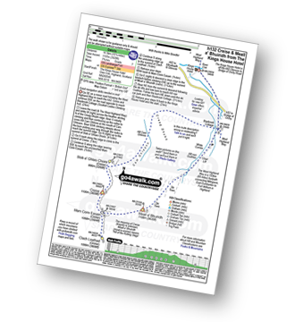
Route Summary:
The Kings House Hotel - Glen Coe - Blackrock Cottage - Cam Ghleann - Stob a' Ghlais Choire (Creise) - Creise - Mam Coire Easain (Creise) - Clach Leathad (Creise) - Meall a' Bhuiridh - Allt Nan Giubhas - White Corries - Blackrock Cottage - The Kings House Hotel - Glen Coe.
|
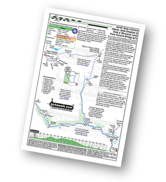
Vital Statistics:
| Length: | 5 miles (8 km) |
| Ascent: | 1,004ft (306m) |
| Time: | 3 hrs |
| Grade: |  |
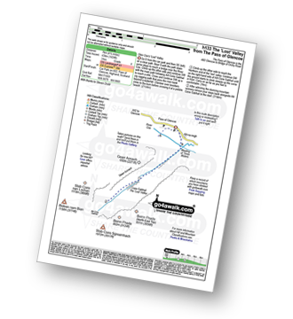
Route Summary:
The Pass of Glencoe - Allt Corrie Gabhail - Coire Gabhail (The 'Lost Valley' of Glen Coe) - The Pass of Glencoe
|
Vital Statistics:
| Length: | 7.5 miles (12 km) |
| Ascent: | 3,016ft (919m) |
| Time: | 6½ hrs |
| Grade: | |
Route Summary:
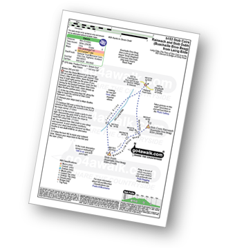
The Pass of Glencoe - Stob Nan Cabar - Stob Coire Raineach (Buachaille Etive Beag) - Buachaille Etive Beag (Stob Dubh) - Lairig Gartain - The Pass of Glencoe
|
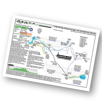
Vital Statistics:
| Length: | 5.5 miles (9 km) |
| Ascent: | 2,501ft (762m) |
| Time: | 5.75hrs |
| Grade: |  |
Route Summary:
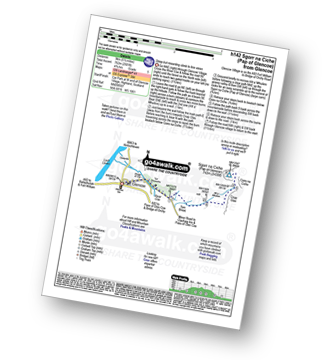
Glencoe Village - The Pass of Glencoe - Sgorr na Ciche (Pap of Glencoe) - Glencoe Village
|
Vital Statistics:
| Length: | 4.25 miles (6.5 km) |
| Ascent: | 2,491ft (759m) |
| Time: | 4 hrs |
| Grade: | |
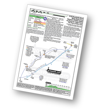
Route Summary:
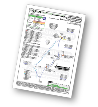
Altnafeadh - The Pass of Glencoe - Lagangarbh Cottage - Allt Coire na Tulaich - Coire na Tulaich - Buachaille Etive Mor (Stob Dearg) - Coire na Tulaich - Allt Coire na Tulaich - Lagangarbh Cottage - The Pass of Glencoe - Altnafeadh.
|
Vital Statistics:
| Length: | 5 miles (8 km) |
| Ascent: | 2,983ft (909m) |
| Time: | 5 hrs |
| Grade: | |
Route Summary:
The Pass of Glencoe - Mam Buidhe - Stob Coire Raineach (Buachaille Etive Beag) - Buachaille Etive Beag (Stob Dubh) - Lairig Eilde - The Pass of Glencoe
|
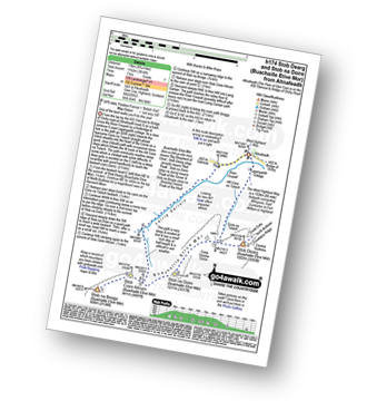
Vital Statistics:
| Length: | 6.5 miles (10.5 km) |
| Ascent: | 2,227ft (679m) |
| Time: | 4½ hrs |
| Grade: | |
Route Summary:
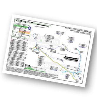
Altnafeadh - A82 The Pass of Glen Coe - Stob Beinn a' Chrulaiste - Beinn a' Chrulaiste - The Kings House Hotel - The Old Military Road - The West Highland Way - A82 The Pass of Glen Coe - (Glencoe).
|
Vital Statistics:
| Length: | 9.75 miles (16.5 km) |
| Ascent: | 5,405ft (1,647m) |
| Time: | 9 hrs |
| Grade: | |
Route Summary:
The Pass of Glencoe - River Coe - Coire Nan Lochan - Aonach Dubh - Stob Coire Nan Lochan (Bidean Nam Bian) - Bidean Nam Bian - Stob Coire Nam Beith (Bidean Nam Bian) - Bidean Nam Bian - Lost Valley Buttress - Bealach Dearg - Stob Coire Sgreamhach - Beinn Fhada (Stob Coire Sgreamhach) - Beinn Fhada (Stob Coire Sgreamhach) (North East Top) - Beinn Fhada (Stob Coire Sgreamhach) (Far North East Top) - Lairig Eilde - Allt Lairig Eilde - The Pass of Glencoe
|
Vital Statistics:
| Length: | 8.75 miles (14 km) |
| Ascent: | 4,040ft (1,231m) |
| Time: | 7.25hrs |
| Grade: | |
Route Summary:
Glencoe Village - Sgorr na Ciche (Pap of Glencoe) - Sgorr Nam Fiannaidh (Aonach Eagach) - Clachaig Inn - Glencoe Village
|
Vital Statistics:
| Length: | 8.25 miles (13 km) |
| Ascent: | 3,814ft (1,162m) |
| Time: | 7 hrs |
| Grade: | |
Route Summary:
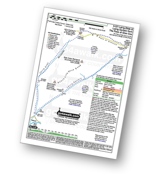
The Pass of Glencoe - A82 - Altnafeadh - Lagangarbh Cottage - Allt Coire na Tulaich - Coire na Tulaich - Buachaille Etive Mor (Stob Dearg) - Feadan Ban (Buachaille Etive Mor) - Stob na Doire (Buachaille Etive Mor) - Stob Coire Altruim (Buachaille Etive Mor) - Stob na Broige (Buachaille Etive Mor) - Lairig Gartain - A82 The Pass of Glencoe.
|
Vital Statistics:
| Length: | 8.25 miles (13 km) |
| Ascent: | 2,993ft (912m) |
| Time: | 6 hrs |
| Grade: | |
Route Summary:
The Pass of Glencoe - Stob Coire Raineach (Buachaille Etive Beag) - Buachaille Etive Beag (Stob Dubh) - Lairig Gartain - The Pass of Glencoe
|
Vital Statistics:
| Length: | 12.25 miles (19.5 km) |
| Ascent: | 4,322ft (1,317m) |
| Time: | 8.75hrs |
| Grade: | |
Route Summary:
A82 - Lochan na Stainge - Ba Cottage - Sron Nam Forsair - Clach Leathad (Creise) - Mam Coire Easain (Creise) - Creise - Stob a' Ghlais Choire (Creise) - Meall a' Bhuiridh - Ba Cottage - Lochan na Stainge - A82
|
Vital Statistics:
| Length: | 7.75 miles (12.5 km) |
| Ascent: | 4,391ft (1,338m) |
| Time: | 7.25hrs |
| Grade: | |
Route Summary:
Pass of Glencoe - Coire Nan Lochan - Stob Coire Nan Lochan (Bidean Nam Bian) - Bidean Nam Bian - Stob Coire Nam Beith (Bidean Nam Bian) - Allt Coire Nam Beithach - A82 - Loch Achtriochtan - The Pass of Glencoe
|
Vital Statistics:
| Length: | 7.75 miles (12.5 km) |
| Ascent: | 4,175ft (1,272m) |
| Time: | 7.25hrs |
| Grade: | |
Route Summary:
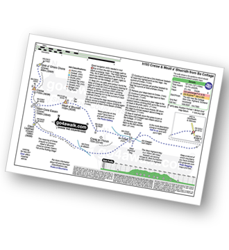
South Ballachulish - Gleann a' Chaolais - Beinn a' Bheithir Ridge - Sgorr Dhearg (Beinn a' Bheithir) - Sgorr Dhonuill (Beinn a' Bheithir) - South Ballachulish - Glencoe.
See this list of walks, routes & maps in:
Grade Order |
Length Order |
Time Order |
Walk Number or Start Location Order
NB. To reverse (toggle) this order, click Grade Order again
To contribute to go4awalk.com or to contact us about anything at all - see Talk To Us. For help see Help.
go4awalk.com and go4awalk.co.uk are registered trademarks of TMDH Limited.
Copyright © 2000-2024 TMDH Limited. All rights reserved.
Copyright | Terms & Conditions | Privacy Statement
A - Z
Walks
Home
Log On/Accounts
Photo Gallery
Walk Ideas and Collections
Fell Facts
Places to Stay
Hill Skills
Walking Questions and Answers
Your Stories
News
Competitions
Product Reviews/Gear Tests
Walking Gear Guides
Peaks and Mountains
Peak Bagging
Find New Walking Friends
Camping
GPS Waypoints for Walking
Walk Search
Talk to us
go4awalk.com Help
Free example walks
Newsletter


